Bethel Township, Lebanon County, Pennsylvania
Bethel Township is a township in Lebanon County, Pennsylvania, United States. It is part of the Lebanon, PA Metropolitan Statistical Area. The population was 5,007 at the 2010 census.[4] Fredericksburg is a census-designated place within the township.
Bethel Township, Lebanon County, Pennsylvania | |
|---|---|
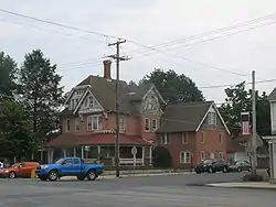 Fredericksburg, the largest community in the township | |
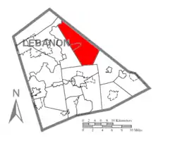 Location in Lebanon County | |
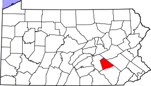 Location of Lebanon County in Pennsylvania | |
| Country | United States |
| State | Pennsylvania |
| County | Lebanon |
| Settled | 1737 |
| Incorporated | 1793 |
| Area | |
| • Total | 34.61 sq mi (89.64 km2) |
| • Land | 34.59 sq mi (89.58 km2) |
| • Water | 0.03 sq mi (0.07 km2) |
| Population (2010) | |
| • Total | 5,007 |
| • Estimate (2016)[2] | 5,186 |
| • Density | 149.95/sq mi (57.90/km2) |
| Time zone | UTC-5 (Eastern (EST)) |
| • Summer (DST) | UTC-4 (EDT) |
| Area code(s) | 717 |
| FIPS code | 42-075-06040 |
| Historical population | |||
|---|---|---|---|
| Census | Pop. | %± | |
| 2000 | 4,526 | — | |
| 2010 | 5,007 | 10.6% | |
| 2016 (est.) | 5,186 | [2] | 3.6% |
| U.S. Decennial Census[3] | |||
Geography
According to the United States Census Bureau, the township has a total area of 34.8 square miles (90 km2), of which, 34.7 square miles (90 km2) of it is land and 0.04 square miles (0.10 km2) of it (0.09%) is water.
Recreation
Portions of the Appalachian National Scenic Trail, Pennsylvania State Game Lands Number 80, and the Swatara State Park are located along the northern portion of the township.[6][7]
Demographics
As of the census[8] of 2000, there were 4,526 people, 1,608 households, and 1,252 families residing in the township. The population density was 130.3 people per square mile (50.3/km2). There were 1,710 housing units at an average density of 49.2/sq mi (19.0/km2). The racial makeup of the township was 98.14% White, 0.27% African American, 0.11% Native American, 0.24% Asian, 0.77% from other races, and 0.46% from two or more races. 1.55% of the population were Hispanic or Latino of any race.
There were 1,608 households, out of which 35.0% had children under the age of 18 living with them, 66.2% were married couples living together, 7.3% had a female householder with no husband present, and 22.1% were non-families. 17.8% of all households were made up of individuals, and 7.1% had someone living alone who was 65 years of age or older. The average household size was 2.81 and the average family size was 3.19.
In the township the population was spread out, with 27.9% under the age of 18, 8.0% from 18 to 24, 29.3% from 25 to 44, 23.8% from 45 to 64, and 11.0% who were 65 years of age or older. The median age was 36 years. For every 100 females, there were 103.5 males. For every 100 females age 18 and over, there were 102.5 males.
The median income for a household in the township was $41,790, and the median income for a family was $47,415. Males had a median income of $31,278 versus $26,411 for females. The per capita income for the township was $17,093. 8.1% of the population and 6.1% of families were below the poverty line. Out of the total population, 12.9% of those under the age of 18 and 13.7% of those 65 and older were living below the poverty line.
References
- "2016 U.S. Gazetteer Files". United States Census Bureau. Retrieved Aug 14, 2017.
- "Population and Housing Unit Estimates". Retrieved June 9, 2017.
- "Census of Population and Housing". Census.gov. Retrieved June 4, 2016.
- "U.S. Census website". United States Census Bureau. Retrieved 2017-03-04.
- "Early history". Reading Eagle. Jun 9, 1896. p. 25. Retrieved 18 October 2015.
- https://viewer.nationalmap.gov/advanced-viewer/ The National Map, retrieved 27 October 2018
- Pennsylvania State Game Lands Number 80, retrieved 27 October 2018
- "U.S. Census website". United States Census Bureau. Retrieved 2008-01-31.
Municipalities and communities of Lebanon County, Pennsylvania, United States | ||
|---|---|---|
| City | | |
| Boroughs | ||
| Townships | ||
| CDPs | ||
| Unincorporated communities | ||
| ||
