Betong District
Betong (Thai: เบตง, pronounced [bēː.tōŋ]; Malay: Betung) is the southernmost district (amphoe) of Yala Province, southern Thailand.
Betong
เบตง | |
|---|---|
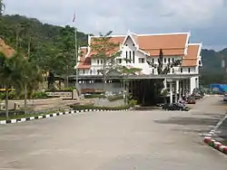 Thai border checkpoint, Betong District. | |
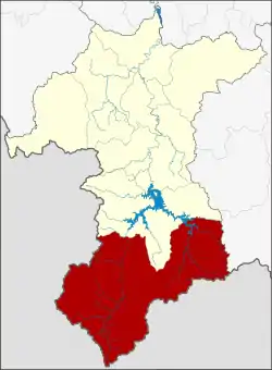 District location in Yala Province | |
| Coordinates: 5°46′25″N 101°3′38″E | |
| Country | Thailand |
| Province | Yala |
| Seat | Betong |
| Tambon | 5 |
| Muban | 32 |
| Area | |
| • Total | 1,328.0 km2 (512.7 sq mi) |
| Population (2017) | |
| • Total | 62,523 |
| • Density | 41.1/km2 (106/sq mi) |
| Time zone | UTC+7 (ICT) |
| Postal code | 95110 |
| Geocode | 9502 |
Geography
Betong is on the Malaysian border. To the north is Than To, to the east is Chanae, (Narathiwat Province). To the south is the Malaysian state of Perak and to the west is Kedah.
The highest point of the Sankalakhiri Range (Northern Titiwangsa Mountains), 1,533 m (5,030 ft) high Ulu Titi Basah (เขาหลวง), is on the Thai–Malaysian border between Betong District and Hulu Perak District of Perak.[1]
History
In the past, this area was under Mueang Raman, Monthon Pattani. It was upgraded to a district in 1868 with the name Yarom. In 1930 the district name was changed to Betong.
The name Betong is the Thai corruption of Betung, its original Malay name means 'bamboo'.[2]
Population
In Betong, ethnic Thai Chinese and Thai Malay Muslims both outnumber native Buddhist Thais. At present there are five Chinese organizations.[3]
Economy
As of 2018 Thailand's transport ministry is constructing the 1.9 billion baht Betong Airport. It is scheduled to be opened in June 2020.[4][5] Designed to handle 300 arrivals per hour, it is projected to serve one million passengers per year, generating three billion baht for the district. Nok Air, Bangkok Airways, and Malaysia's Firefly Airlines have plans to fly to Betong.[6]
Administration
Central administration
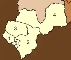
Betong is divided into five sub-districts (tambons), which are further subdivided into 32 administrative villages (mubans).
| No. | Name | Thai | Villages | Pop.[7] |
|---|---|---|---|---|
| 1. | Betong | เบตง | - | 26,663 |
| 2. | Yarom | ยะรม | 8 | 10,266 |
| 3. | Tano Maero | ตาเนาะแมเราะ | 9 | 9,436 |
| 4. | Aiyoeweng | อัยเยอร์เวง | 11 | 11,703 |
| 5. | Than Nam Thip | ธารน้ำทิพย์ | 4 | 4,455 |
Local administration
There is one town (thesaban mueang) in the district:
- Betong (Thai: เทศบาลเมืองเบตง) consisting of sub-district Betong.
There is one sub-district municipality (thesaban tambon) in the district:
- Than Nam Thip (Thai: เทศบาลตำบลธารน้ำทิพย์) consisting of sub-district Than Nam Thip.
There are three sub-district administrative organizations (SAO) in the district:
- Yarom (Thai: องค์การบริหารส่วนตำบลยะรม) consisting of sub-district Yarom.
- Tano Maero (Thai: องค์การบริหารส่วนตำบลตาเนาะแมเราะ) consisting of sub-district Tano Maero.
- Aiyoeweng (Thai: องค์การบริหารส่วนตำบลอัยเยอร์เวง) consisting of sub-district Aiyoeweng.
Gallery
 Entrance to the Piyamit Tunnels in Tana Maero subdistrict.
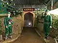 Entrance 3 of the Piyamit Tunnels.
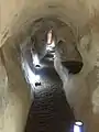 Piyamit Tunnels which were used by Malayan Communist insurgents.
 One of the props at the Piyamit Tunnels.
 Sea of Mist lookout point at Iyerweng
 Sea of Mist lookout point at Iyerweng
 Bonamron Hot Spring, Tano Maero subdistrict.
 Hot spring water swimming pool at Bonamron Hot Spring, Tano Maero subdistrict.
- Thai immigration checkpoint at the Betong-Bukit Berapit border crossing.
 Thai immigration checkpoint at the Betong-Bukit Berapit border crossing.
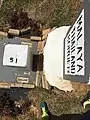 Malaysia-Thailand boundary stone at the Betong-Bukit Berapit border crossing.
 Entry and exit stamps from Betong checkpoint.
References
- "Gunong Ulu Titi Basah: Thailand". Geographical Names. Retrieved 4 May 2018.
- "Betong Town". Tourism Authority of Thailand (TAT). Retrieved 20 March 2019.
- Yenbamrung, Natthida. "เมืองเบตง: คนไทยเชื้อสายจีนที่เข้มแข็ง" [Betong: Thai-Chinese Strong]. Future Urban Development, Rangsit University (in Thai).
- "Govt plans DMK-Betong flight roster". Bangkok Post. 19 May 2019. Retrieved 19 May 2019.
- Sritama, Suchat (27 August 2018). "Better days around the bend". Bangkok Post. Retrieved 27 August 2018.
- Nanuam, Wassana (5 July 2019). "Betong airport runway will be extended, says army chief". Bangkok Post. Retrieved 5 July 2019.
- "Population statistics 2017" (in Thai). Department of Provincial Administration. Retrieved 2018-06-19.
