Betul, Madhya Pradesh
Betul is located at an elevation of over 2,000 feet above sea level, this region is rich in forests and biodiversity, making its climate pleasant throughout the year. Unlike the other parts of the state, Betul, which lies in the plains of the Satpura range, is a pleasant, peaceful getaway from dusty city life.The capital city Bhopal is 180 km and its nearer cities are chindwara, Nagpur, khandwa, Hoshangabad, Harda etc.
Betul
Baitool | |
|---|---|
City | |
 Betul | |
| Coordinates: 21.905°N 77.902°E | |
| Country | India |
| State | Madhya Pradesh |
| District | Betul |
| Area | |
| • Total | 193 km2 (75 sq mi) |
| Elevation | 658 m (2,159 ft) |
| Population (2011) | |
| • Total | 153,330 |
| • Rank | 19 |
| • Density | 790/km2 (2,100/sq mi) |
| Languages | |
| • Official | Hindi |
| Time zone | UTC+5:30 (IST) |
| ISO 3166 code | IN-MP |
| Vehicle registration | MP 48 |
| Website | www |
Although little is known or documented about the ancient history of Betul, it is well known that the region’s most influential rulers were the Marathas in the 19th century, who left their indelible marks in the forms of temples and places of worship. A number of Hindu and Jain temples are scattered around the area, many of which date back to centuries ago, appealing to both the religious and those interested in history and archaeology. If you’re looking for an aesthetically pleasing getaway in the heart of the country, Betul is the place to go.
Built on a hilltop, Muktagiri is known for the Jain temple it houses and its scenic views. It is a sacred place of worship for Jains who come here from across the country to seek blessings.
Perhaps the best-known temple in Betul is the Balajipuram Temple located about eight kilometers from the city center. Sprawling across 15 acres, the temple is a tall structure and modern in architecture, having been built in 2001. It hosts a fair every year during the festival of Basant Panchami.
Kukrukhamla, Sona Ghati, Multai and the Shapna Water Reservoir are other nearby tourist places.
Betul is also known for the fairs and festivals it hosts through the year, the largest and most notable one being Kavi Diwas, founded in the city in 2012.
Name
During the early 20th century, Betul was known as Badnur.[1] It derives its present name from its surrounding district, which was named for its former headquarters at Betul Bazar, a small town about 5 km (3 mi) to its south. Betul—literally "without" (be) "cotton" (tool)—was named for its position outside the area's cottonfields.
History
Betul is one of the marginally located southern districts of Madhya Pradesh, lying almost wholly on the Satpura. It occupies nearly the whole width of the satpura range between the valley of the narmada on the north and the bearer plains on the south. It forms the southernmost part of the Bhopal Division. The District extends between 21-22 and 22-24 degrees North Latitude and between 77-10 and 78-33 degrees East Longitude and forms a compact shape, almost a square with slight projection on the East and the West. Two small enclaves of the district, viz., Batla blocks of the Govt. forests lie to the West between the districts of Nimar (East) and Amaraoti. These enclaves lie on the Northern bank of the Tapti. They extent from West to East between the Meridians 77-59 and 77-02.
Boundaries
The District is bounded on the NORTH by Hoshangabad, on the SOUTH by Amarawati of Maharastra, on the EAST by Chhindwara District and on the WEST by the District of Hoshangabad, East Nimar and Amarawati. The Southern boundary of the district runs almost along the southern foothills of the melghat range, but excludes hattighat and Chikalda hills in Amaroti district. The Western boundary is associated for some distance with the Ganjal river (Southern), a tributary of Tapti, and then with the watershed line between the Morand and the Ganjal (Northern), the tributaries of the Narmada. The Northern boundary is marked by the course of the Morand river, and by the TAWA river beyond Dhodra Mohar Railway station. The Eastern Boundary runs through small streams and hills among which Khurpura and Rotia Nalas are of some significance.
Name
The district derives its name from the small town of Betul Bazar about 5 km south of Badnur, the Headquarters of the district. During the Maratha regime also, in the beginning of the British rule, Betul or Betul Bazar was the district Headquarters. In 1822 the District Headquarters was shifted to the present place, then only the village came to be known as Badnur Dhana, meaning Badnur village in the local dialect. Now, even after such a long time, not only the district retains the old name, but the name of the new Headquarters town, Badnur, as also been superimposed by “BETUL”.
NAMES OF THE DYNASTIES RUINED
Vakataka dynasty, RASTRAKUTAS, KHERALA, SULTANS OF MALWA, MUGHALS, GONDS, BHONSLE, BRITISH
MAJOR RELIGIONS,CASTES AND LANGUAGES
RELIGION : HINDU, MUSLIM, SIKH, JAIN, CHRISTIAN, BUDDHIST.
CASTES : GONDS, KORKUS, KURMIS, KUNBIS, BHOYARS, MEHARAS, CHAMARS, BANIAS, RAJPUTHS.
LANGUAGES : HINDI, GONDI, MARATHI, KORKU.
Geography
Betul is located at 21.92°N 77.9°E,[2] near the geographical center point of modern India. It has an average elevation of 658 m (2,159 ft).
Climate
| Climate data for Betul, Madhya Pradesh (1981–2010, extremes 1948–2012) | |||||||||||||
|---|---|---|---|---|---|---|---|---|---|---|---|---|---|
| Month | Jan | Feb | Mar | Apr | May | Jun | Jul | Aug | Sep | Oct | Nov | Dec | Year |
| Record high °C (°F) | 34.9 (94.8) |
37.8 (100.0) |
42.3 (108.1) |
43.7 (110.7) |
48.0 (118.4) |
44.5 (112.1) |
38.6 (101.5) |
33.6 (92.5) |
35.5 (95.9) |
36.8 (98.2) |
35.0 (95.0) |
32.7 (90.9) |
48.0 (118.4) |
| Average high °C (°F) | 27.4 (81.3) |
30.1 (86.2) |
34.6 (94.3) |
38.7 (101.7) |
40.3 (104.5) |
35.7 (96.3) |
29.2 (84.6) |
27.6 (81.7) |
29.8 (85.6) |
31.1 (88.0) |
29.1 (84.4) |
27.8 (82.0) |
31.8 (89.2) |
| Average low °C (°F) | 10.5 (50.9) |
11.9 (53.4) |
16.1 (61.0) |
20.6 (69.1) |
24.7 (76.5) |
24.4 (75.9) |
22.5 (72.5) |
21.8 (71.2) |
21.1 (70.0) |
17.3 (63.1) |
13.4 (56.1) |
10.2 (50.4) |
17.9 (64.2) |
| Record low °C (°F) | −0.2 (31.6) |
1.1 (34.0) |
2.3 (36.1) |
10.6 (51.1) |
16.6 (61.9) |
14.9 (58.8) |
14.5 (58.1) |
13.1 (55.6) |
10.5 (50.9) |
5.0 (41.0) |
2.6 (36.7) |
1.3 (34.3) |
−0.2 (31.6) |
| Average rainfall mm (inches) | 13.8 (0.54) |
14.2 (0.56) |
19.7 (0.78) |
6.9 (0.27) |
13.3 (0.52) |
144.5 (5.69) |
330.1 (13.00) |
371.7 (14.63) |
189.8 (7.47) |
57.8 (2.28) |
20.6 (0.81) |
8.6 (0.34) |
1,191 (46.89) |
| Average rainy days | 1.1 | 1.5 | 1.4 | 0.7 | 0.9 | 8.0 | 15.2 | 15.5 | 8.8 | 3.2 | 1.7 | 0.8 | 58.7 |
| Average relative humidity (%) (at 17:30 IST) | 44 | 34 | 25 | 20 | 24 | 53 | 77 | 84 | 74 | 60 | 52 | 47 | 50 |
| Source: India Meteorological Department[3][4] | |||||||||||||
Demographics
During the 2011 Indian census, Betul had a population of 103,330. Males constitute 51.12% of the population, females 48.88%. Betul has an average literacy rate of 89.28%, higher than the national average of 74.04%. 10.82% of the population is under 6 years of age.[5]
Economy
Betul District's economy is predominantly an agrarian one. Its dense woods also permit forestry. Its road and rail connections and good telecom services have led some to predict that Betul will become an advanced industrial district.
Betul District supports a number of cottage industries employing 667 people, 5 medium- or large-scale industries with a workforce of 999 people. Of the 33 SSI's, 8 are agricultural, 13 are mineral-based, and 1 is forest-based. The five larger industrial plants are:
- M/s. Betul Oils & Flours Ltd., Kosmi Industrial Area
- M/s. Madhyavarta Ex-oil Ltd., Kosmi Industrial Area
- M/s. Adhishwar Oil & Fats Ltd. Chouthia, Multai
- M/s. Betul Tyre & Tube Industry Pvt. Ltd., Sohagpur
- M/s. Wearwell Tyre & Tube Industries, Panka, Amla
Transport
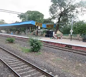
Betul is connected to the broad-gauge Delhi–Chennai (Grand Trunk) line of the Indian rail network, which also communicates with Bhopal and Nagpur. Two new railway lines are also proposed - Betul - Chandur Bazar[6] and Betul -Harda -Indore. Betul Railway station has 94 trains, to various parts of country like Delhi, Chennai, Hyderabad, Bangalore, Jaipur, Lucknow, Kanpur, Bhopal, Indore, Harda, Jabalpur, Nagpur etc.
Betul is serviced by National Highway 46 and National Highway 47, also connecting it with Bhopal and Nagpur. National Highway 47 connects it to Harda Indore as well. There are daily buses to Bhopal, Nagpur, Harda and Indore, as well as Jabalpur, Hoshangabad, and other cities. Betul's RTO code is MP48.
The nearest airports are at Nagpur and Bhopal, about 180 km (112 mi) away. The tyre industry also uses the area's waterways for export to the United States, the UK, the Middle East, and Africa.
Education
In Betul, there are total 72 number of colleges. Some main colleges are as follows[7]
- Govt Jaywanti Haksar P G College Betul
- Government polytechnic college sonaghati betul
- Bhimrao Ramrao Ambedkar College Of Education, Run By Shri Ram Shiksha Parishad, Chakkar Road Ambedk
- Late Shri Nandkishore Singh Patel Memorial College, Near Link Road, Sadar, Betul
- Netaji Subhas Chandra Bose College
- Shri Ram Pharmacy College Jamthi Betul
- Shri Balaji Institute of Technology & Management, Betul
- Vivekanand Vigyan Mahavidyalay (VVM), Betul
- Law College, Betul
Tourism
.jpg.webp)
- Umari Jagir - Hazrat Ghazi Dulhe Rehman Shah Dargah
- Muktagiri is Jain temple approximately 120 km (75 mi) from Betul.
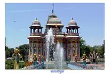
- Balaji Puram is home to the Lord Balaji temple. This place comes under Betul Bazar Nagar Panchayat. The District Headquarters is located on National Highway 69, only 7 kilometers from Betul. Apart from this, there is a temple of Vaishnava Devi. To go there you have to go through the cave centers.
- Kukrukhamla is a scenic spot.
- Multai is the origin of the Tapti River and a place of religious importance. It is situated on the Bhopal-Nagpur Highway about 50 km (31 mi) from Betul.
- Sarniis the power hub of madhya Pradesh and also a tourist attraction. There is a Mathardev temple which is surrounded by hills of satpura mountains and there is satpura reservoir which is situated near satpura dam.
Other tourist spots include Sona Ghati, Kerpani, the Shapna Water Reservoir, rachana water fall, betul fort, churna Wildlife reserve, hanuman temple.
Notes
- EB (1911).
- Falling Rain Genomics, Inc - Betul
- "Station: Betul Climatological Table 1981–2010" (PDF). Climatological Normals 1981–2010. India Meteorological Department. January 2015. pp. 123–124. Archived from the original (PDF) on 5 February 2020. Retrieved 28 December 2020.
- "Extremes of Temperature & Rainfall for Indian Stations (Up to 2012)" (PDF). India Meteorological Department. December 2016. p. M115. Archived from the original (PDF) on 5 February 2020. Retrieved 28 December 2020.
- "Census of India 2011: Data from the 2001 Census, including cities, villages and towns (Provisional)". Census Commission of India. Archived from the original on 16 June 2004. Retrieved 1 November 2008.
- "Archived copy" (PDF). Archived from the original (PDF) on 1 December 2017. Retrieved 23 November 2017.CS1 maint: archived copy as title (link)
- "District Administration Betul" (PDF). District Administration Betul.
References
- Baynes, T. S., ed. (1878), , Encyclopædia Britannica, 3 (9th ed.), New York: Charles Scribner's Sons, pp. 228–229
- Chisholm, Hugh, ed. (1911), , Encyclopædia Britannica, 3 (11th ed.), Cambridge University Press, p. 190