Bezirk Halle
The Bezirk Halle was a district (Bezirk) of East Germany. The administrative seat and the main town was Halle.
Bezirk Halle | |
|---|---|
District | |
.svg.png.webp) Coat of arms | |
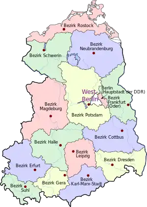
 Location of Bezirk Halle within the German Democratic Republic | |
| Coordinates: 51°30′N 12°0′E | |
| Country | German Democratic Republic |
| Subdivisions | 20 Kreise and 3 Stadtkreise |
| Formed | 1952 |
| Dissolved | 1990 |
| Seat | Halle |
| Area | |
| • Total | 8,771 km2 (3,387 sq mi) |
| Population (1989)[1] | |
| • Total | 1,776,500 |
| • Density | 200/km2 (520/sq mi) |
| Vehicle registration | K, V |
History
The district was established, with the other 13, on 25 July 1952, substituting the old German states. After 3 October 1990 it was disestablished as a consequence of the German reunification, becoming again part of the state of Saxony-Anhalt except Artern kreis, which became part of Thuringia.
Geography
Position
The Bezirk Halle bordered with the Bezirke of Magdeburg, Potsdam, Cottbus, Leipzig, Gera and Erfurt.
Subdivision
The Bezirk was divided into 23 Kreise: 3 urban districts (Stadtkreise) and 20 rural districts (Landkreise):
- Urban districts : Dessau; Halle; Halle-Neustadt.[2]
- Rural districts : Artern; Aschersleben; Bernburg; Bitterfeld; Eisleben; Gräfenhainichen; Hettstedt; Hohenmölsen; Köthen; Merseburg; Naumburg; Nebra; Quedlinburg; Querfurt; Roßlau; Saalkreis; Sangerhausen; Weißenfels; Wittenberg; Zeitz.
References
- "40 Jahre DDR", National central administration for statistics, May 1989
- Former city, now a quarter part of Halle
External links
![]() Media related to Halle District (GDR) at Wikimedia Commons
Media related to Halle District (GDR) at Wikimedia Commons
| Authority control |
|---|
This article is issued from Wikipedia. The text is licensed under Creative Commons - Attribution - Sharealike. Additional terms may apply for the media files.
