Bickerstaffe
Bickerstaffe is a village and civil parish in the West Lancashire district of Lancashire, England. According to the 2001 Census the population of the civil parish was 1,196,[1] reducing to 1,180 at the 2011 census,[3] although the population of the electoral ward, which includes Lathom South, was slightly greater at 2,013,[2] reducing to 1,988 at the 2011 census.[4] The village is near junction 3 of the M58 motorway, and is about four miles west of Skelmersdale. Until October 1936 Bickerstaffe Colliery was located just south of junction 3.[5][6]
| Bickerstaffe | |
|---|---|
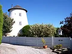 The old windmill | |
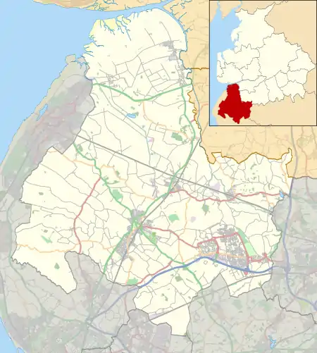 Bickerstaffe Location in West Lancashire  Bickerstaffe Location within Lancashire | |
| Population | 1,196 (Parish)[1] 2,013 (Ward)[2] (2001 Census) |
| OS grid reference | SD445045 |
| Civil parish |
|
| District | |
| Shire county | |
| Region | |
| Country | England |
| Sovereign state | United Kingdom |
| Post town | ORMSKIRK |
| Postcode district | L39 |
| Dialling code | 01695 |
| Police | Lancashire |
| Fire | Lancashire |
| Ambulance | North West |
| UK Parliament | |
Its name may come from Anglo-Saxon bïcera stæþ = "the beekeepers' landing-place".
In the seventeenth century, Bickerstaffe was an important local centre of the Quakers in West Lancashire.
The parish church is dedicated to the Holy Trinity. Being built in 1843, and then extended in 1860, with a bell tower and spire to the west. It was designed by architect Sydney Smirke, with multiple examples of fine masonry. Such as the carved angles above the doorway, as well as royal heads carved into the accent stones either side of each of the northern and western windows.
Public houses and restaurants in the area include The Stanley Gate, The Sandpipers and Quattros.
The grounds of Bickerstaffe AFC are at Hall Lane next to Bickerstaffe C.E school.
An annual music festival, Bickerstock, takes place in the summer season, featuring local and international artists, and drawing in increasingly large crowds.
Bickerstaffe Stocks are one of the listed structures of historical importance in the village.[7]
Bickerstaffe's Little Chef closed in 2012. It is now a Starbucks.
2012 saw the start of United Utilities £63m scheme at Bickerstaffe Water Treatment works to reduce the reliance of the local water supply on the River Dee. That initiative comes in two parts: drilling new boreholes to find new water sources, and extending Bickerstaffe Water Treatment Works to cope with the rising demand for water.
See also
References
- 2001 Census: Bickerstaffe (Parish), Office for National Statistics, retrieved 25 January 2009
- 2001 Census: Bickerstaffe (Ward), Office for National Statistics, retrieved 25 January 2009
- "Civil Parish 2011". Retrieved 16 January 2016.
- "Ward population 29011". Retrieved 16 January 2016.
- "Side by side georeferenced maps viewer - Map images - National Library of Scotland". Maps.nls.uk. Retrieved 19 January 2017.
- "Bickerstaffe Coal Colliery information and photos". Aditnow.co.uk. 24 October 1936. Retrieved 19 January 2017.
- Bickerstaffe stocks at britishlistedbuildings.co.uk