Big Bay, Michigan
Big Bay is an unincorporated community in Marquette County of the U.S. state of Michigan. It is a census-designated place (CDP) for statistical purposes and does not have any legal status as an incorporated municipality. As of the 2010 census, the CDP had a population of 319. The community is located within Powell Township near the shore of "Big Bay" on Lake Superior.
Big Bay, Michigan | |
|---|---|
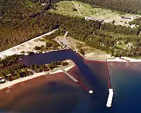 Aerial view of the harbor at Big Bay | |
%252C_MI_location.png.webp) Location within Marquette County | |
 Big Bay Location within the state of Michigan  Big Bay Big Bay (the United States) | |
| Coordinates: 46°48′57″N 87°43′42″W | |
| Country | United States |
| State | Michigan |
| County | Marquette |
| Township | Powell |
| Founded | 1875 |
| Area | |
| • Total | 5.94 sq mi (15.4 km2) |
| • Land | 3.78 sq mi (9.8 km2) |
| • Water | 2.16 sq mi (5.6 km2) |
| Elevation | 682 ft (208 m) |
| Population (2010) | |
| • Total | 319 |
| • Density | 84.4/sq mi (32.6/km2) |
| Time zone | UTC−5 (Eastern (EST)) |
| • Summer (DST) | UTC−4 (EDT) |
| ZIP code(s) | 49808 |
| Area code(s) | 906 |
| FIPS code | 26-08180[1] |
| GNIS feature ID | 621285[2] |
Although the Big Bay community is served by the Marquette ZIP code 49855,[3] the Big Bay post office with ZIP code 49808, serves a much larger area to the west and south of the community and CDP, including portions of Powell Township as well as Ishpeming, Champion, Michigamme, and Ely townships.[4]
History
Big Bay was established in 1875 by people involved in the lumber industry.[5]
Geography
According to the United States Census Bureau, the CDP has a total area of 5.94 square miles (15.38 km2), of which 3.78 square miles (9.79 km2) is land and 2.16 square miles (5.59 km2) (36.36%) is water.[6]
Demographics
As of the census[1] of 2000, there were 265 people, 129 households, and 86 families residing in the CDP. The population density was 69.2 per square mile (26.7/km2). There were 300 housing units at an average density of 78.3 per square mile (30.2/km2). The racial makeup of the CDP was 96.23% White, 2.26% Native American, and 1.51% from two or more races.
There were 129 households, out of which 15.5% had children under the age of 18 living with them, 59.7% were married couples living together, 3.9% had a female householder with no husband present, and 32.6% were non-families. 28.7% of all households were made up of individuals, and 13.2% had someone living alone who was 65 years of age or older. The average household size was 2.05 and the average family size was 2.47.
In the CDP, the population was spread out, with 15.1% under the age of 18, 3.4% from 18 to 24, 20.4% from 25 to 44, 37.7% from 45 to 64, and 23.4% who were 65 years of age or older. The median age was 51 years. For every 100 females, there were 105.4 males. For every 100 females age 18 and over, there were 114.3 males.
The median income for a household in the CDP was $34,750, and the median income for a family was $42,708. Males had a median income of $35,417 versus $24,375 for females. The per capita income for the CDP was $18,620. About 7.9% of families and 11.4% of the population were below the poverty line, including 8.7% of those under the age of eighteen and 4.6% of those 65 or over.
Culture
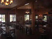
Big Bay's "claim to fame" is the filming of Anatomy of a Murder in 1959. Filming took place at the Thunder Bay Inn, the Big Bay Lighthouse Bed and Breakfast, the Lumberjack Tavern (scene of the real 1952 crime on which the film is based), Perkins Park Campground, and various other locales.[7]
Bay Cliff Health Camp is located in Big Bay. It is a year-round, non-profit wellness camp for children and adults with physical disabilities.[8]
Climate
This climatic region is typified by large seasonal temperature differences, with warm to hot (and often humid) summers and cold (sometimes severely cold) winters. According to the Köppen Climate Classification system, Big Bay has a humid continental climate, abbreviated "Dfb" on climate maps.[9]
| Climate data for Big Bay, Michigan (1981–2010 normals, extremes 1945–present) | |||||||||||||
|---|---|---|---|---|---|---|---|---|---|---|---|---|---|
| Month | Jan | Feb | Mar | Apr | May | Jun | Jul | Aug | Sep | Oct | Nov | Dec | Year |
| Record high °F (°C) | 53 (12) |
60 (16) |
83 (28) |
92 (33) |
95 (35) |
97 (36) |
103 (39) |
102 (39) |
95 (35) |
86 (30) |
78 (26) |
63 (17) |
103 (39) |
| Average high °F (°C) | 25.4 (−3.7) |
27.9 (−2.3) |
37.4 (3.0) |
50.4 (10.2) |
63.4 (17.4) |
72.0 (22.2) |
77.4 (25.2) |
76.2 (24.6) |
68.7 (20.4) |
55.3 (12.9) |
41.8 (5.4) |
28.8 (−1.8) |
52.1 (11.2) |
| Daily mean °F (°C) | 17.9 (−7.8) |
19.4 (−7.0) |
27.6 (−2.4) |
39.8 (4.3) |
51.2 (10.7) |
60.6 (15.9) |
66.2 (19.0) |
65.4 (18.6) |
58.0 (14.4) |
45.9 (7.7) |
34.6 (1.4) |
22.2 (−5.4) |
42.4 (5.8) |
| Average low °F (°C) | 10.5 (−11.9) |
10.9 (−11.7) |
17.8 (−7.9) |
29.1 (−1.6) |
38.9 (3.8) |
49.3 (9.6) |
54.9 (12.7) |
54.5 (12.5) |
47.3 (8.5) |
36.5 (2.5) |
27.4 (−2.6) |
15.6 (−9.1) |
32.7 (0.4) |
| Record low °F (°C) | −20 (−29) |
−32 (−36) |
−18 (−28) |
3 (−16) |
18 (−8) |
28 (−2) |
33 (1) |
34 (1) |
24 (−4) |
15 (−9) |
−2 (−19) |
−15 (−26) |
−32 (−36) |
| Average precipitation inches (mm) | 2.07 (53) |
1.47 (37) |
1.92 (49) |
2.24 (57) |
2.80 (71) |
3.37 (86) |
3.27 (83) |
3.38 (86) |
3.53 (90) |
3.46 (88) |
2.53 (64) |
2.08 (53) |
32.12 (816) |
| Source: NOAA[10][11] | |||||||||||||
References
Notes
- "U.S. Census website". United States Census Bureau. Retrieved 2008-01-31.
- U.S. Geological Survey Geographic Names Information System: Big Bay, Michigan
- 49855 5-Digit ZCTA, 498 3-Digit ZCTA - Reference Map - American FactFinder, U.S. Census Bureau, 2000 census
- 49808 5-Digit ZCTA, 498 3-Digit ZCTA - Reference Map - American FactFinder, U.S. Census Bureau, 2000 census
- Romig 1986, p. 60.
- "Michigan: 2010 Population and Housing Unit Counts 2010 Census of Population and Housing" (PDF). 2010 United States Census. United States Census Bureau. September 2012. p. 32 Michigan. Retrieved August 28, 2020.
- "John D. Voelker". 50th Anniversary Anatomy of a Murder. Northern Michigan University. Retrieved 22 November 2018.
- "About Us". Bay Cliff Health Camp. 2014. Retrieved 22 November 2018.
- Climate Summary for Big Bay, Michigan
- "NowData - NOAA Online Weather Data". National Oceanic and Atmospheric Administration. Retrieved July 29, 2016.
- "MI Big Bay 1NW". National Oceanic and Atmospheric Administration. Retrieved July 29, 2016.
Sources
- Romig, Walter (October 1, 1986) [1973]. Michigan Place Names: The History of the Founding and the Naming of More Than Five Thousand Past and Present Michigan Communities. Great Lakes Books Series (Paperback). Detroit, Michigan: Wayne State University Press. ISBN 0-8143-1838-X. ISBN 978-0814318386.
Municipalities and communities of Marquette County, Michigan, United States | ||
|---|---|---|
| Cities | 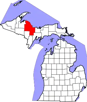 Map of Michigan highlighting Marquette County.svg | |
| Charter townships | ||
| Civil townships | ||
| CDPs | ||
| Other unincorporated communities | ||
| Indian reservations | ||
| Footnotes | ‡This populated place also has portions in an adjacent county or counties | |
| ||