Republic, Michigan
Republic is an unincorporated community in Marquette County in the U.S. state of Michigan. It is also a census-designated place (CDP) for statistical purposes and no legal status as an incorporated municipality. The CDP had a population of 570 at the 2010 census. The community is located mostly within Republic Township with a small portion extending north into Humboldt Township.
Republic, Michigan | |
|---|---|
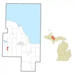 Location within Marquette County | |
 Republic Location within the state of Michigan  Republic Republic (the United States) | |
| Coordinates: 46°24′24″N 87°58′32″W | |
| Country | United States |
| State | Michigan |
| County | Marquette |
| Townships | Humboldt and Republic |
| Area | |
| • Total | 3.93 sq mi (10.2 km2) |
| • Land | 3.62 sq mi (9.4 km2) |
| • Water | 0.31 sq mi (0.8 km2) |
| Elevation | 1,522 ft (464 m) |
| Population (2010) | |
| • Total | 570 |
| • Density | 157.46/sq mi (60.80/km2) |
| Time zone | UTC-5 (Eastern (EST)) |
| • Summer (DST) | UTC-4 (EDT) |
| ZIP code(s) | 49879 |
| Area code(s) | 906 |
| FIPS code | 26-67980[2] |
| GNIS feature ID | 634306[1] |
The Republic 49879 ZIP Code covers a much larger area than the CDP, including most of Republic Township and a small portion of Mansfield Township in Iron County.[3]
History
A post office called Republic has been in operation since 1873.[4] The community was named after the Republic Iron Company.[5]
From 1980 to 2004, the US Navy operated an extremely low frequency (76 Hz) submarine communication site near Republic under Project ELF.[6][7][8]
Geography
According to the United States Census Bureau, the community has a total area of 3.93 square miles (10.18 km2), of which 3.62 square miles (9.38 km2) is land and 0.31 square miles (0.80 km2) (7.89%) is water.
The community occupies areas of two townships. The majority of the boundaries are within Republic Township, which contains 3.65 square miles (9.45 km2) (92.87%) of total area and 567 residence. Only three residents live within the smaller Humboldt Township portion of the CDP.[9]
The Michigamme River forms most of the eastern boundary of the CDP, while M-95 forms the entire western boundary.
Demographics

As of the census[2] of 2000, there were 614 people, 276 households, and 187 families residing in the community. The population density was 170.1 per square mile (65.7/km2). There were 356 housing units at an average density of 98.6 per square mile (38.1/km2). The racial makeup of the community was 98.05% White, 1.63% Native American, and 0.33% from two or more races.
There were 276 households, out of which 26.4% had children under the age of 18 living with them, 52.5% were married couples living together, 10.1% had a female householder with no husband present, and 31.9% were non-families. 30.1% of all households were made up of individuals, and 17.4% had someone living alone who was 65 years of age or older. The average household size was 2.22 and the average family size was 2.67.
In the community, the population was spread out, with 21.2% under the age of 18, 4.9% from 18 to 24, 23.8% from 25 to 44, 25.6% from 45 to 64, and 24.6% who were 65 years of age or older. The median age was 45 years. For every 100 females, there were 90.7 males. For every 100 females age 18 and over, there were 87.6 males.
The median income for a household in the community was $24,545, and the median income for a family was $29,659. Males had a median income of $24,875 versus $18,472 for females. The per capita income for the community was $14,793. About 10.7% of families and 15.1% of the population were below the poverty line, including 19.1% of those under age 18 and 16.2% of those age 65 or over.
Education
Republic is served by the Republic-Michigamme School District, which operates the Republic-Michigamme High School.
References
- U.S. Geological Survey Geographic Names Information System: Republic, Michigan
- "U.S. Census website". United States Census Bureau. Retrieved 2008-01-31.
- 49879 5-Digit ZCTA, 498 3-Digit ZCTA - Reference Map - American FactFinder, U.S. Census Bureau, 2000 census.
- "Marquette County". Jim Forte Postal History. Retrieved 26 March 2015.
- Chicago and North Western Railway Company (1908). A History of the Origin of the Place Names Connected with the Chicago & North Western and Chicago, St. Paul, Minneapolis & Omaha Railways. p. 117.
- "Info" (PDF). www.hep.wisc.eduf.
- "Archived copy". Archived from the original on 2016-04-13. Retrieved 2016-02-12.CS1 maint: archived copy as title (link)
- "SEAFARER Extremely Low Frequency (ELF) Submarine Command and Control Communications". www.nmu.edu.
- "Michigan: 2010 Population and Housing Unit Counts 2010 Census of Population and Housing" (PDF). 2010 United States Census. United States Census Bureau. September 2012. p. 32 Michigan. Retrieved August 28, 2020.
Municipalities and communities of Marquette County, Michigan, United States | ||
|---|---|---|
| Cities | 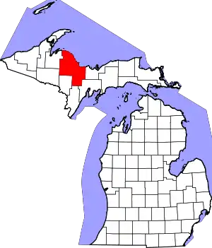 Map of Michigan highlighting Marquette County.svg | |
| Charter townships | ||
| Civil townships | ||
| CDPs | ||
| Other unincorporated communities | ||
| Indian reservations | ||
| Footnotes | ‡This populated place also has portions in an adjacent county or counties | |
| ||