Birobidzhansky District
Birobidzhansky District (Russian: Биробиджа́нский райо́н) is an administrative[1] and municipal[5] district (raion), one of the five in the Jewish Autonomous Oblast, Russia. It is located in the center of the autonomous oblast. The area of the district is 4,442.56 square kilometers (1,715.28 sq mi).[2] Its administrative center is the town of Birobidzhan (which is not administratively a part of the district).[1] Population: 11,907 (2010 Census);[3] 13,018 (2002 Census);[8] 15,437 (1989 Census).[9]
Birobidzhansky District
Биробиджанский район | |
|---|---|
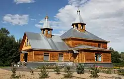 Convent of St. Innocent, village of Razdolnoye, Birobidzhansky District | |
 Coat of arms | |
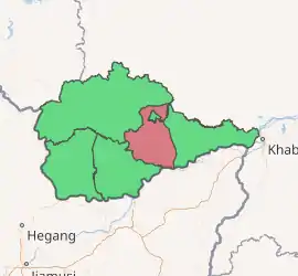
Location of Birobidzhansky District in the Jewish Autonomous Oblast | |
| Coordinates: 48°47′N 132°56′E | |
| Country | Russia |
| Federal subject | Jewish Autonomous Oblast[1] |
| Established | 1934 |
| Administrative center | Birobidzhan[1] |
| Area | |
| • Total | 4,442.56 km2 (1,715.28 sq mi) |
| Population | |
| • Total | 11,907 |
| • Estimate (2018)[4] | 11,224 (−5.7%) |
| • Density | 2.7/km2 (6.9/sq mi) |
| • Urban | 0% |
| • Rural | 100% |
| Administrative structure | |
| • Inhabited localities[1] | 20 Rural localities |
| Municipal structure | |
| • Municipally incorporated as | Birobidzhansky Municipal District[5] |
| • Municipal divisions[6] | 0 Urban settlements, 6 Rural settlements |
| Time zone | UTC+10 (MSK+7 |
| OKTMO ID | 99605000 |
| Website | http://br.eao.ru/ |
Geography
Birobidzhansky District is located in the central of the Jewish Autonomous Oblast. The main river in the district is the Bira River, which runs north-to-south through the district. About 20 km of the Amur River runs along the southern border of Birobidzhansky. The district is about 125 km west of the city of Khabarovsk, and the area measures 90 km (north-south) by 70 km (west-east). The administrative center, Birobidzhan, straddles the Bira River in the north but is not administratively part of the district.[2] Bira River valley of the district is surrounded by foothills of the Lesser Khingan mountains. the area has deposits of brown coal and peat.[2]
The district is bordered on the north and west by Obluchensky District, on the east by Smidovichsky District, on the south by Leninsky District, Jewish Autonomous Oblast and a short border with China.
History
Officially, the area had come under control of Russia in 1858 after the Treaty of Aigun with China. The treaty set the Amur River as border between the two countries. Settlers began drifting in, mostly from the Trans-Baikal area, over the following years. The village of Golovino reaching a population of 400 by the year 1891, with a school, a post office, and a chapel.[10] Another wave of population growth came in 1890–1910 with the construction of the Trans-Siberian Railway and the Amur Cart Road; these migrants were mostly from Central Russia and Volga regions. New villages spread north from the Amur along the Bira River.[10]
The first large migration of Jews began in the 1920s, who founded at least half a dozen villages in the district. They established an Experimental Farm (later the Research Institute of Agriculture) to develop farming practices more appropriate to the area, as the heavy summer rains interfered with harvests and the soils and climate were different from European Russia.[10] Until the 1930s, there were few roads and transportation centered on a 60-horsepower steamer that worked up and down the Bira from the Amur to the town of Birobidzhan. Good roads did not begin to appear until the 1950s-1960s.
The current district administration was formed in 1942 as the area was growing in importance and was supplying food to the war effort. At the time, there were 5,883 people in the district, on 1683 farms and 12 collectives. Late in 1942, the village of Valdgame contributed 250,000 rubles to support the squadron "Jewish Farmer". Agriculture improved in the post-war years with the introduction of fertilizers, pesticides, and crop rotation.[10]
Administrative and municipal status
Within the framework of administrative divisions, Birobidzhansky District is one of the five in the autonomous oblast.[1] The town of Birobidzhan serves as its administrative center, despite being incorporated separately as a town of oblast significance—an administrative unit with the status equal to that of the districts.[1]
As a municipal division, the district is incorporated as Birobidzhansky Municipal District.[5] The town of oblast significance of Birobidzhan is incorporated separately from the district as Birobidzhan Urban Okrug.[11]
References
Notes
- Law #982-OZ
- "General Information" (in Russian). Birobidzhansky District. Retrieved August 31, 2016.
- Russian Federal State Statistics Service (2011). "Всероссийская перепись населения 2010 года. Том 1" [2010 All-Russian Population Census, vol. 1]. Всероссийская перепись населения 2010 года [2010 All-Russia Population Census] (in Russian). Federal State Statistics Service.
- "26. Численность постоянного населения Российской Федерации по муниципальным образованиям на 1 января 2018 года". Federal State Statistics Service. Retrieved 23 January 2019.
- Law #227-OZ
- Law #339-OZ
- "Об исчислении времени". Официальный интернет-портал правовой информации (in Russian). 3 June 2011. Retrieved 19 January 2019.
- Russian Federal State Statistics Service (21 May 2004). "Численность населения России, субъектов Российской Федерации в составе федеральных округов, районов, городских поселений, сельских населённых пунктов – районных центров и сельских населённых пунктов с населением 3 тысячи и более человек" [Population of Russia, Its Federal Districts, Federal Subjects, Districts, Urban Localities, Rural Localities—Administrative Centers, and Rural Localities with Population of Over 3,000] (XLS). Всероссийская перепись населения 2002 года [All-Russia Population Census of 2002] (in Russian).
- "Всесоюзная перепись населения 1989 г. Численность наличного населения союзных и автономных республик, автономных областей и округов, краёв, областей, районов, городских поселений и сёл-райцентров" [All Union Population Census of 1989: Present Population of Union and Autonomous Republics, Autonomous Oblasts and Okrugs, Krais, Oblasts, Districts, Urban Settlements, and Villages Serving as District Administrative Centers]. Всесоюзная перепись населения 1989 года [All-Union Population Census of 1989] (in Russian). Институт демографии Национального исследовательского университета: Высшая школа экономики [Institute of Demography at the National Research University: Higher School of Economics]. 1989 – via Demoscope Weekly.
- "History of the District". Birobizhansky District. Retrieved October 30, 2016.
- Law #226-OZ
Sources
- Законодательное Собрание Еврейской автономной области. Закон №982-ОЗ от 20 июля 2011 г. «Об административно-территориальном устройстве Еврейской автономной области». Вступил в силу через 10 дней после дня официального опубликования. Опубликован: "Биробиджанская звезда", №54, 29 июля 2011 г. (Legislative Assembly of the Jewish Autonomous Oblast. Law #982-OZ of July 20, 2011 On the Administrative-Territorial Structure of the Jewish Autonomous Oblast. Effective as of the day which is 10 days after the day of the official publication.).
- Законодательное Собрание Еврейской автономной области. Закон №227-ОЗ от 26 ноября 2003 г. «О статусе и границе Биробиджанского муниципального района», в ред. Закона №760-ОЗ от 26 мая 2010 г. «О внесении изменений в некоторые Законы Еврейской автономной области». Вступил в силу через 10 дней после официального опубликования. Опубликован: "Биробиджанская звезда", №93, 23 декабря 2003 г. (Legislative Assembly of the Jewish Autonomous Oblast. Law #227-OZ of November 26, 2003 On the Status and Borders of Birobidzhansky Municipal District, as amended by the Law #760-OZ of May 26, 2010 On Amending Various Laws of the Jewish Autonomous Oblast. Effective as of the day which is 10 days after the official publication.).
- Законодательное Собрание Еврейской автономной области. Закон №339-ОЗ от 2 ноября 2004 г. «О границах и статусе сельских поселений в составе Биробиджанского муниципального района». Вступил в силу через 10 дней после дня официального опубликования. Опубликован: "Биробиджанер штерн", №89, 9 декабря 2004 г. (Legislative Assembly of the Jewish Autonomous Oblast. Law #339-OZ of November 2, 2004 On the Borders and Status of the Rural Settlements Within Birobidzhansky Municipal District. Effective as of the day which is 10 days after the day of the official publication.).
- Законодательное Собрание Еврейской автономной области. Закон №226-ОЗ от 26 ноября 2003 г. «О статусе и границе городского округа "город Биробиджан"», в ред. Закона №340-ОЗ от 2 ноября 2004 г «О внесении изменений в некоторые законы Еврейской автономной области о статусе и границе муниципальных районов, городского округа». Вступил в силу через 10 дней после официального опубликования. Опубликован: "Биробиджанская звезда", №93, 23 декабря 2003 г. (Legislative Assembly of the Jewish Autonomous Oblast. Law #226-OZ of November 26, 2003 On the Status and the Border of the Urban Okrug of the "City of Birobidzhan", as amended by the Law #340-OZ of November 2, 2004 On Amending Several Laws of the Jewish Autonomous Oblast on the Status and the Borders of the Municipal Districts, an Urban Okrug. Effective as of the day which is 10 days after the official publication.).
External links
| Districts | |||
|---|---|---|---|
| Towns | |||
| Urban-type settlements | |||