Bogolyubovo, Vladimir Oblast
Bogolyubovo (Russian: Боголю́бово) is a rural locality (a settlement) in Suzdalsky District of Vladimir Oblast, Russia, located some 10 kilometers (6.2 mi) northeast of Vladimir, the administrative center of the oblast. Population: 4,494 (2010 Census);[1] 4,218 (2002 Census);[4] 4,143 (1989 Census);[5] 3,900 (1969).
Bogolyubovo
Боголюбово | |
|---|---|
Settlement[1] | |
 Aerial view of Bogolyubovo | |
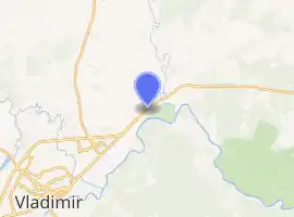
Location of Bogolyubovo 
| |
 Bogolyubovo Location of Bogolyubovo  Bogolyubovo Bogolyubovo (Vladimir Oblast) | |
| Coordinates: 56°11′N 40°32′E | |
| Country | Russia |
| Federal subject | Vladimir Oblast[1] |
| Administrative district | Suzdalsky District[1] |
| Founded | 1158 |
| Rural locality status since | 2006 |
| Elevation | 131 m (430 ft) |
| Population | |
| • Total | 4,494 |
| Time zone | UTC+3 (MSK |
| Postal code(s)[3] | 601270 |
| Dialing code(s) | +7 4922 |
| OKTMO ID | 17654403101 |
History
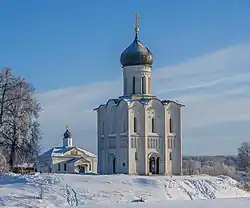
It was built between 1158 and 1165 by the order of Andrey Bogolyubsky at the mouth of the Nerl River (where it flows into the Klyazma River). Russian Orthodox Christians believe that Bogolyubovo was founded on the spot where Bogolyubsky saw a miraculous vision of the Theotokos, who commanded him to build a church and a monastery on this spot. Consequently, the Church of the Intercession on the Nerl was built here. The church has been on UNESCO World Heritage List since 1992.[6]

Bogolyubsky also commissioned the icon of the apparition of the Theotokos. This icon has been known as the Bogolubskaya Icon of the Theotokos.
After Bogolyubsky's death, Bogolyubovo was ravaged and ransacked by Gleb of Ryazan in 1177. In the 1230s, the Mongols destroyed its fortifications.
In 1960–2006, Bogolyubovo had urban-type settlement status.
References
- Russian Federal State Statistics Service (2011). "Всероссийская перепись населения 2010 года. Том 1" [2010 All-Russian Population Census, vol. 1]. Всероссийская перепись населения 2010 года [2010 All-Russia Population Census] (in Russian). Federal State Statistics Service.
- "Об исчислении времени". Официальный интернет-портал правовой информации (in Russian). June 3, 2011. Retrieved January 19, 2019.
- Почта России. Информационно-вычислительный центр ОАСУ РПО. (Russian Post). Поиск объектов почтовой связи (Postal Objects Search) (in Russian)
- Russian Federal State Statistics Service (May 21, 2004). "Численность населения России, субъектов Российской Федерации в составе федеральных округов, районов, городских поселений, сельских населённых пунктов – районных центров и сельских населённых пунктов с населением 3 тысячи и более человек" [Population of Russia, Its Federal Districts, Federal Subjects, Districts, Urban Localities, Rural Localities—Administrative Centers, and Rural Localities with Population of Over 3,000] (XLS). Всероссийская перепись населения 2002 года [All-Russia Population Census of 2002] (in Russian).
- "Всесоюзная перепись населения 1989 г. Численность наличного населения союзных и автономных республик, автономных областей и округов, краёв, областей, районов, городских поселений и сёл-райцентров" [All Union Population Census of 1989: Present Population of Union and Autonomous Republics, Autonomous Oblasts and Okrugs, Krais, Oblasts, Districts, Urban Settlements, and Villages Serving as District Administrative Centers]. Всесоюзная перепись населения 1989 года [All-Union Population Census of 1989] (in Russian). Институт демографии Национального исследовательского университета: Высшая школа экономики [Institute of Demography at the National Research University: Higher School of Economics]. 1989 – via Demoscope Weekly.
- UNESCO. World Heritage. White Monuments of Vladimir and Suzdal
External links
 Bogolyubovo travel guide from Wikivoyage
- Main sights in Bogolyubovo
- Information about the Bogolyubovo Monastery