Bolshesosnovsky District
Bolshesosnovsky District (Russian: Большесосно́вский райо́н) is an administrative district (raion) of Perm Krai, Russia; one of the thirty-three in the krai.[1] Municipally, it is incorporated as Bolshesosnovsky Municipal District.[5] It is located in the southwest of the krai. The area of the district is 2,220 square kilometers (860 sq mi).[2] Its administrative center is the rural locality (a selo) of Bolshaya Sosnova.[1] Population: 13,215 (2010 Census);[3] 15,295 (2002 Census);[7] 16,955 (1989 Census).[8] The population of Bolshaya Sosnova accounts for 33.5% of the district's total population.[3]
Bolshesosnovsky District
Большесосновский район | |
|---|---|
.png.webp) Flag _-_2.png.webp) Coat of arms | |
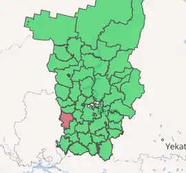
Location of Bolshesosnovsky District in Perm Krai | |
| Coordinates: 57.542°N 53.898°E | |
| Country | Russia |
| Federal subject | Perm Krai[1] |
| Established | March 18, 1924[2] |
| Administrative center | Bolshaya Sosnova[1] |
| Area | |
| • Total | 2,220 km2 (860 sq mi) |
| Population | |
| • Total | 13,215 |
| • Estimate (2018)[4] | 12,497 (−5.4%) |
| • Density | 6.0/km2 (15/sq mi) |
| • Urban | 0% |
| • Rural | 100% |
| Administrative structure | |
| • Inhabited localities[1] | 62 Rural localities |
| Municipal structure | |
| • Municipally incorporated as | Bolshesosnovsky Municipal District[5] |
| • Municipal divisions[5] | 0 Urban settlements, 7 Rural settlements |
| Time zone | UTC+5 (MSK+2 |
| OKTMO ID | 57608000 |
| Website | http://bsosnovsky.ru/ |
Geography
The main rivers of the district are the Siva with its tributaries the Sosnovka and the Chyornaya. About 32% of the district's territory is covered by forests—one of the lowest rates in the krai.
History
The district was established on March 18, 1924.[2] In 1963, the district was abolished[2] and split between Chastinsky and Ochyorsky Districts. In December 1968, the district was restored.[2]
Economy
The economy of the district is based on agriculture, which accounts for about 81% of the total district's GDP.
Demographics
The most numerous ethnic groups, according to the 2002 Census, include Russians at 92.9%, Udmurts at 2.4%, and Tatars at 1.3%.[2]
See also
References
Notes
- Law #416-67
- Encyclopedia of Perm Krai. Entry on Bolshesosnovsky District Archived March 31, 2012, at the Wayback Machine (in Russian)
- Russian Federal State Statistics Service (2011). "Всероссийская перепись населения 2010 года. Том 1" [2010 All-Russian Population Census, vol. 1]. Всероссийская перепись населения 2010 года [2010 All-Russia Population Census] (in Russian). Federal State Statistics Service.
- "26. Численность постоянного населения Российской Федерации по муниципальным образованиям на 1 января 2018 года". Federal State Statistics Service. Retrieved January 23, 2019.
- Law #1880-408
- "Об исчислении времени". Официальный интернет-портал правовой информации (in Russian). June 3, 2011. Retrieved January 19, 2019.
- Russian Federal State Statistics Service (May 21, 2004). "Численность населения России, субъектов Российской Федерации в составе федеральных округов, районов, городских поселений, сельских населённых пунктов – районных центров и сельских населённых пунктов с населением 3 тысячи и более человек" [Population of Russia, Its Federal Districts, Federal Subjects, Districts, Urban Localities, Rural Localities—Administrative Centers, and Rural Localities with Population of Over 3,000] (XLS). Всероссийская перепись населения 2002 года [All-Russia Population Census of 2002] (in Russian).
- "Всесоюзная перепись населения 1989 г. Численность наличного населения союзных и автономных республик, автономных областей и округов, краёв, областей, районов, городских поселений и сёл-райцентров" [All Union Population Census of 1989: Present Population of Union and Autonomous Republics, Autonomous Oblasts and Okrugs, Krais, Oblasts, Districts, Urban Settlements, and Villages Serving as District Administrative Centers]. Всесоюзная перепись населения 1989 года [All-Union Population Census of 1989] (in Russian). Институт демографии Национального исследовательского университета: Высшая школа экономики [Institute of Demography at the National Research University: Higher School of Economics]. 1989 – via Demoscope Weekly.
Sources
- Законодательное собрание Пермской области. Закон №416-67 от 28 февраля 1996 г. «Об административно-территориальном устройстве Пермского края», в ред. Закона №504-ПК от 9 июля 2015 г. «О внесении изменений в Закон Пермской области "Об административно-территориальном устройстве Пермского края"». Вступил в силу с момента опубликования. Опубликован: "Звезда", №38, 12 марта 1996 г. (Legislative Assembly of Perm Oblast. Law #416-67 of February 28, 1996 On the Administrative-Territorial Structure of Perm Krai, as amended by the Law #504-PK of July 9, 2015 On Amending the Law of Perm Oblast "On the Administrative-Territorial Structure of Perm Krai". Effective as of the moment of publication.).
- Законодательное собрание Пермской области. Закон №1880-408 от 9 декабря 2004 г. «Об утверждении границ и о наделении статусом муниципальных образований Большесосновского района Пермского края», в ред. Закона №328-ПК от 7 июня 2014 г. «О внесении изменений в отдельные Законы Пермской области и Коми-Пермяцкого автономного округа». Вступил в силу через десять дней со дня официального опубликования. Опубликован: "Бюллетень Законодательного Собрания и администрации Пермской области", №1, II часть, 27 января 2005 г. (Legislative Assembly of Perm Oblast. Law #1880-408 of December 9, 2004 On Establishing the Borders and on Granting the Status to the Municipal Formations of Bolshesosnovsky District of Perm Krai, as amended by the Law #328-PK of June 7, 2014 On Amending Various Laws of Perm Oblast and Komi-Permyak Autonomous Okrug. Effective as of the day which is ten days following the day of the official publication.).
| Administrative districts |
| ||
|---|---|---|---|
| Administrative districts of Komi-Permyak Okrug | |||
| Closed administrative-territorial formations | |||
| Cities and towns (all levels) | |||
| Urban-type settlements | |||