Bournillon cave
The Bournillon cave (French: grotte de Bournillon) is located in the commune of Châtelus in the Isère Department of France, in the Vercors Massif. It has the highest cave opening in Europe (418 meters).[1] It is one of the main karst springs of Vercors, with a maximum flow rate of 80 cubic meters per second.
| Bournillon Cave | |
|---|---|
| Grotte de Bournillon | |
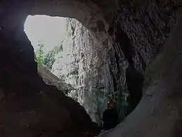 Opening of the Bournillon cave, the highest in Europe. | |
 | |
| Location | Isère, France |
| Coordinates | 45°03′16″N 5°25′57″E |
| Length | 7886m |
| Elevation | 418m |
| Geology | Limestone |
Exploration history
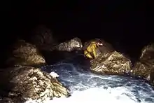
In 1897 a team led by French spelunker Oscar Decombaz (1866 - 1914) explored the grotto as far as the Metro Needle where the galley becomes a siphon. In 1942 André Bourgin and Roger Pénelon found the upper gallery and the lateral gallery. Attempts to dive at the Metro Needle siphon did not achieve significant upstream penetration.[2] An exceptional drought in 1985 allowed Maurice and Franck Chiron to discover 1600 meters of new galleries, coming to a point of 95 m higher than the cave entrance, for the highest point of the two siphons Alpha and Beta.[3] David Bianzani and other speleonauts probed the siphons, but further upstream exploration remains for future speleonauts.[4]
Description
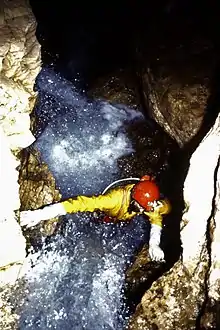
Above the lake at the entrance the middle galley articulates with the main gallery after a ledge. Progress along the gallery stops under a pond of siphoned water called the Metro Needle.[5]
In some years, given four or five dry months, the right branch of the Metro Needle may permit access upstream, after the siphon is defused. The labyrinth is the key passage, and life threatening in case a thunderstorm occurs. The gallery of centaurs, 30 × 10 meters, gives way to a crawl space leading up to another gallery: Minos Center. The gallery of the Elysian Fields, some ten meters in size, splits into Siphon Alpha and Siphon Beta. These siphons continue towards the south-by-southwest (500 mètres for -36 m for Siphon Beta, and 543 meters by -85 m for Siphon Alpha).[6]
Hydrology
Lower in the Bournillon Gorge is the Sources de Arbois, which is the normal resurgence for the catchment area, which constitutes much of southern Vercors: the high plateau of Vercors and the Vassieux High Plateaux. When the Sources de Arbois flow in excess of 3.5 cubic meters/second, the overflow goes into the Bournillon system. When the flow rate in the cave exceeds 40 cubic meters/sec, then another overflow starts at the Luire cave.[7] The stream from the Bournillon flows into the Bourne, which is a tributary of the Isère river, and from thence to the Rhône.
Geology
The cave developed at the bottom of an Urgonian limestone formation. Dating one of the stalagmites indicated that the speleothem had been formed more than 350,000 years ago. The formation of the cavity, 200 meters above the gorges of the Bourne, goes back 3–4 million years before the present, to the Pliocene Epoch.[2]
References
- Liz Wheeler, ed. (2003). Earth. p. 256. ISBN 1-4053-0018-3.
- Caillault, Serge; Haffner, Dominique; Krattinger, Thierry; Delannoy, Jean-Jacques (1999). Spéléo sportive dans le Vercors-Tome 2 [Speleological adventures in the Vercours: Volume Two] (in French). Aix-en-Provence: Edisud. pp. 162–165. ISSN 0764-2520.
- Chiron, Maurice; Lismonde, Baudouin; Fédération française de spéléologie (1985). "Bournillon: histoire de la progression vers le sud" [Bournillon: History of progress towards the south] (PDF). Scialet: bulletin du CDS de l'Isère (in French). Comité départemental de spéléologie de l'Isère. 14: 46–54. ISSN 0336-0326.
- Bianzani, David; Garnier, Marlène (2017). "Vercors: grotte de Bournillon - Les plongées des siphons terminaux" [Vercors: Bournillon Cave - Diving into the last siphons]. Spéléo (in French). Vol. 100. Corenc: Spéléo magazine. pp. 18–23. ISSN 1629-1573.
- Chiron, Maurice (2002). "Bournillon et son labyrinthe, Bournillon et sa rivière, Hydrogéologie du système Luire-Arbois-Bournillon, Bibliographie de Bournillon" (PDF). Scialet: bulletin du CDS de l'Isère (in French). Comité départemental de spéléologie de l'Isère. 31: 55–75. ISSN 0336-0326.
- Bianzani, David (2018). "Vercors: grotte de Bournillon - Campagne de plongées pour Alpha et Bêta". Spéléo (in French). Vol. 103. Corenc: Spéléo magazine. pp. 6–7. ISSN 1629-1573.
- Delannoy, Jean-Jacques; Maire, Richard (1984). "Les grandes cavités alpines. Répartition et contexte hydrogéologique" [Large alpine cavities. Distribution and hydrogeological context]. karstologia (in French). Fédération française de spéléologie and Association française de karstologie..