Vassieux-en-Vercors
Vassieux-en-Vercors is a commune in the department of Drôme in southeastern France.
Vassieux-en-Vercors | |
|---|---|
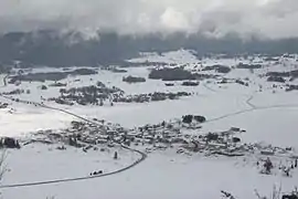 Vassieux-en-Vercors seen from the slopes of the col de la Chau, near the Mémorial de la Résistance | |
.svg.png.webp) Coat of arms | |
Location of Vassieux-en-Vercors 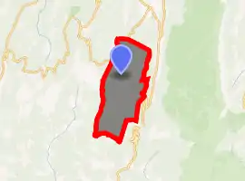
| |
 Vassieux-en-Vercors  Vassieux-en-Vercors | |
| Coordinates: 44°53′46″N 5°22′15″E | |
| Country | France |
| Region | Auvergne-Rhône-Alpes |
| Department | Drôme |
| Arrondissement | Die |
| Canton | Vercors-Monts du Matin |
| Government | |
| • Mayor (2008–2014) | Michel Repellin |
| Area 1 | 48.25 km2 (18.63 sq mi) |
| Population (2017-01-01)[1] | 313 |
| • Density | 6.5/km2 (17/sq mi) |
| Time zone | UTC+01:00 (CET) |
| • Summer (DST) | UTC+02:00 (CEST) |
| INSEE/Postal code | 26364 /26420 |
| Elevation | 1,028–1,654 m (3,373–5,427 ft) (avg. 1,048 m or 3,438 ft) |
| 1 French Land Register data, which excludes lakes, ponds, glaciers > 1 km2 (0.386 sq mi or 247 acres) and river estuaries. | |
The town is known for its assistance to the French Resistance during World War II, for which it was awarded the Ordre de la Libération.
Geography
The village is built on a polje of limestone and dominated by a vast Karst landscape.[2] This polje lies on a syncline generally known as the "Plateau de Vassieux".
The Plateau de Vassieux is the site of numerous other karst phenomena, such as limestone pavements and caves, which are studied and explored by local speleology groups.
History
Vassieux-en-Vercors is home to several prehistoric archaeological sites, and has a Museum of Prehistory which was created in May 1970 after the discovery of a flintknapping workshop.[3]
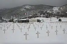
In June and July 1944, during the Second World War, the French Resistance, known as the Maquis du Vercors, staged a major uprising against the German occupation in Vercors and proclaimed the Free Republic of Vercors. It was the first democratic territory in France since the beginning of the German occupation in 1940 - the revolt was brutally suppressed. For its great acts of resistance the town was awarded the Ordre de la Libération. A memorial was built at the Col de la Chau 44.90760°N 5.36124°E to remember the grim events of the Second World War, and includes a cemetery where the victims of a July 1944 German massacre are buried.
Population
| Year | Pop. | ±% |
|---|---|---|
| 1793 | 866 | — |
| 1800 | 921 | +6.4% |
| 1806 | 1,302 | +41.4% |
| 1821 | 930 | −28.6% |
| 1831 | 1,003 | +7.8% |
| 1836 | 1,022 | +1.9% |
| 1841 | 978 | −4.3% |
| 1846 | 899 | −8.1% |
| 1851 | 981 | +9.1% |
| 1856 | 941 | −4.1% |
| 1861 | 930 | −1.2% |
| 1866 | 850 | −8.6% |
| 1872 | 800 | −5.9% |
| 1876 | 773 | −3.4% |
| 1881 | 758 | −1.9% |
| 1886 | 741 | −2.2% |
| 1891 | 701 | −5.4% |
| 1896 | 660 | −5.8% |
| 1901 | 641 | −2.9% |
| 1906 | 622 | −3.0% |
| 1911 | 540 | −13.2% |
| 1921 | 486 | −10.0% |
| 1926 | 474 | −2.5% |
| 1931 | 448 | −5.5% |
| 1936 | 430 | −4.0% |
| 1946 | 309 | −28.1% |
| 1954 | 373 | +20.7% |
| 1962 | 194 | −48.0% |
| 1968 | 257 | +32.5% |
| 1975 | 257 | +0.0% |
| 1982 | 310 | +20.6% |
| 1990 | 283 | −8.7% |
| 1999 | 290 | +2.5% |
| 2008 | 351 | +21.0% |
Economy
The main human and economic activities are based on agriculture (livestock, timber etc.) and tourism.
See also
References
- "Populations légales 2017". INSEE. Retrieved 6 January 2020.
- Centre Historique de la Résistance en Drôme. "Cartographie de Vassieux-en-Vercors" (in French). Retrieved 2008-01-01.
- prehistoire-vercors.fr. "Le Musée de la Préhistoire de Vassieux en Vercors" (in French). Archived from the original on 2007-12-15. Retrieved 2008-01-01.
| Wikimedia Commons has media related to Vassieux-en-Vercors. |
| Authority control |
|
|---|