Bowling Green, Ohio
Bowling Green is a city and the county seat of Wood County, Ohio, United States,[11] located 20 miles southwest of Toledo. The population was 30,028 at the 2010 census. It is part of the Toledo Metropolitan Area and a member of the Toledo Metropolitan Area Council of Governments.[12] Bowling Green is the home of Bowling Green State University.
Bowling Green, Ohio | |
|---|---|
 Downtown Bowling Green, Ohio as seen from the intersection of Main St. and Wooster St. | |
 Seal | |
| Nicknames: BG, Pull Town, USA | |
 Location in Ohio | |
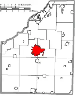 Location of Bowling Green in Wood County | |
| Coordinates: 41°22′26″N 83°39′3″W | |
| Country | United States |
| State | Ohio |
| County | Wood |
| Incorporated | 1901[1] |
| Government | |
| • Type | "Mayor-Administrator"[2] |
| • Mayor | Mike Aspacher[3] |
| • Municipal Administrator | Lori Tretter[4] |
| Area | |
| • City | 12.84 sq mi (33.25 km2) |
| • Land | 12.79 sq mi (33.13 km2) |
| • Water | 0.05 sq mi (0.12 km2) 0.40% |
| Elevation | 696 ft (212 m) |
| Population | |
| • City | 30,028 |
| • Estimate (2019)[7] | 31,504 |
| • Density | 2,463.17/sq mi (951.03/km2) |
| • Metro | 651,429[8] |
| census | |
| Time zone | UTC-5 (EST) |
| • Summer (DST) | UTC-4 (EDT) |
| Zip code | 43402,43403 |
| Area code(s) | 419, 567 |
| FIPS code | 39-07972[9] |
| GNIS feature ID | 1048538[10] |
| Website | https://www.bgohio.org |
History
Settlement
Bowling Green was first settled in 1832, was incorporated as a town in 1855, and became a city in 1901. The village was named after Bowling Green, Kentucky, by a retired postal worker who had once delivered mail there.[13][14]
Oil boom
With the discovery of oil in the late 19th and early 20th century, Bowling Green experienced a boom to its economy. The wealth can still be seen in the downtown storefronts, and along Wooster Street, where many of the oldest and largest homes were built.[15] A new county courthouse was also constructed in the 1890s, and a Neoclassical post office was erected in 1913.[16]
Industrialization
This period was followed by an expansion of the automobile industry. In late 1922 or early 1923, Coats Steam Car moved to the area, but eventually went out of business. Bank Robbers Pretty Boy Floyd and Billy the Killer encountered police in Bowling Green in April 1931, resulting in the death of Billy the Killer.[17] In World War II Italian and German prisoners of war were used to staff the Heinz Tomato Ketchup factory in town.[18] The ketchup factory closed in 1975.[19] The CSX 8888 incident passed through Bowling Green in 2001.[20]
Geography
According to the United States Census Bureau, the city has a total area of 12.61 square miles (32.66 km2), of which 12.56 square miles (32.53 km2) is land and 0.05 square miles (0.13 km2) is water.[21] Bowling Green is within an area of land that was once the Great Black Swamp which was drained and settled in the 19th century. The nutrient-rich soil makes for highly productive farm land. Bowling Green, Ohio is in the North Western hemisphere at approximately 41.376132°N, -83.623897°W.
Demographics
| Historical population | |||
|---|---|---|---|
| Census | Pop. | %± | |
| 1870 | 906 | — | |
| 1880 | 1,539 | 69.9% | |
| 1890 | 3,467 | 125.3% | |
| 1900 | 5,067 | 46.1% | |
| 1910 | 5,222 | 3.1% | |
| 1920 | 5,788 | 10.8% | |
| 1930 | 6,688 | 15.5% | |
| 1940 | 7,190 | 7.5% | |
| 1950 | 12,005 | 67.0% | |
| 1960 | 13,574 | 13.1% | |
| 1970 | 21,760 | 60.3% | |
| 1980 | 25,745 | 18.3% | |
| 1990 | 28,176 | 9.4% | |
| 2000 | 29,636 | 5.2% | |
| 2010 | 30,028 | 1.3% | |
| 2019 (est.) | 31,504 | [7] | 4.9% |
| U.S. Decennial Census[22] | |||
2010 census
As of the census[6] of 2010, there were 30,028 people, 11,288 households, and 4,675 families living in the city. The population density was 2,390.8 inhabitants per square mile (923.1/km2). There were 12,301 housing units at an average density of 979.4 per square mile (378.1/km2). The racial makeup of the city was 87.6% White, 6.4% African American, 0.2% Native American, 2.1% Asian, 1.4% from other races, and 2.2% from two or more races. Hispanic or Latino of any race were 4.8% of the population.[23]
There were 11,288 households, of which 18.9% had children under the age of 18 living with them, 30.7% were married couples living together, 7.5% had a female householder with no husband present, 3.2% had a male householder with no wife present, and 58.6% were non-families. 35.8% of all households were made up of individuals, and 7.2% had someone living alone who was 65 years of age or older. The average household size was 2.16 and the average family size was 2.82.[24]
The median age in the city was 23.2 years. 12.8% of residents were under the age of 18; 43.2% were between the ages of 18 and 24; 19.5% were from 25 to 44; 15.7% were from 45 to 64; and 8.9% were 65 years of age or older. The gender makeup of the city was 48.0% male and 52.0% female.
2000 census
As of the census[9] of 2000, there were 29,636 people, 10,266 households, and 4,434 families living in the city. The population density was 2,919.0 people per square mile (1,127.3/km2). There were 10,667 housing units at an average density of 1,050.6 per square mile (405.8/km2). The racial makeup of the city was 91.84% White, 2.82% African American, 0.21% Native American, 1.83% Asian, 0.02% Pacific Islander, 1.81% from other races, and 1.46% from two or more races. Hispanic or Latino of any race were 3.48% of the population.
There were 10,266 households, out of which 20.2% had children under the age of 18 living with them, 33.2% were married couples living together, 7.5% had a female householder with no husband present, and 56.8% were non-families. 34.3% of all households were people living alone, including 7.0% who were 65 years of age or older. The average household size was 2.21, and the average family size was 2.84.
In the city, the population was spread out, with 13.1% under the age of 18, 46.6% from 18 to 24, 19.5% from 25 to 44, 13.2% from 45 to 64, and 7.6% who were 65 years of age or older. The median age was 22 years. For every 100 females, there were 87.9 males. For every 100 females age 18 and over, there were 85.4 males.
The median income for a household in the city was $30,599, and the median income for a family was $51,804. Males had a median income of $33,619 versus $25,364 for females. The per capita income for the city was $15,032. About 8.0% of families and 25.3% of the population were below the poverty line, including 12.8% of those under age 18 and 4.8% of those age 65 or over.
Arts and culture
Black Swamp Arts Festival

Every September, the Black Swamp Arts Festival takes place in Bowling Green. Started in 1993,[25] the festival has grown in size and prestige.
The name Black Swamp was chosen for the festival because it is a common term for this area of the state. The Great Black Swamp, which was drained near the end of the 1800s to make farming possible, extended from Lake Erie to Indiana. It was the last area of Ohio to be settled. Bowling Green is the largest city now in the remnants of this vast wetland.
Main Street is closed to traffic for the festival, and artists from around the country display and sell a variety of artwork. There are also musical performances, children's activities, and food. The festival has grown to include over 100 juried artists, 50 local/invitational artists, four live music stages, youth arts, acts of art, and concessions. Numerous types of music, including blues, jazz, and rock, are heard from the main stage. The Festival has a reputation for booking a diverse and entertaining musical line up. The Main Stage features national and international touring bands of all genres. The Black Swamp Arts Festival attracts 40,000 art and music fans to Bowling Green.
National Tractor Pulling championships

Bowling Green has hosted the National Tractor Pulling Championships since 1967. This annual event, one of the largest in the nation, is held at the Wood County Fairgrounds and draws an estimated 60,000 people. The Fairgrounds is located along Poe Road between Haskins Road (State Route 64) and Brim Road.
Wood County Fair
Every year Bowling Green hosts the Wood County Fair, a week-long festival that begins shortly before or after the end of July. The fairgrounds are located off Poe Road between Haskins and Brim roads. Main Events include: Tractor Pull, Altered Farm stock Tractor Pull, Antique Tractor Pull, Mule Pull, Semi-Truck Pull, Youth Parade, Demolition/Combine Derby, Catch-a-pig, Cheerleading Competition, Harness Racing, and the annual Country Music Concert. Another special event is quilt day. Special Days like Senior Citizen day or DARE day allow discounted tickets.
Country singers who have performed at the Wood County Fair:
- Boxcar Willie (1982)[26]
- Phil Vassar and Miranda Lambert (2006)
- Tracy Lawrence and Josh Turner (2007)
- Jason Michael Carroll and Billy Currington (2008)
- Little Big Town (2009)
- Kenny Rogers (2010)
- Gretchen Wilson (2012)
- Oak Ridge Boys and Night Ranger (2015)
Winterfest
Similar to other winter cities, Bowling Green hosts an annual event for three days in February to celebrate winter, snow, and cold weather activities. Winterfest in Bowling Green centers around the rich ice skating and ice hockey traditions of the town.[27] Winterfest events are held all over Bowling Green, and on and off campus of Bowling Green State University. Notable events include curling, carriage rides, ice sculptures, and live entertainment, plus BGSU Athletic events such as hockey and basketball games and figure skating exhibition with local stars such as Scott Hamilton.[28]
Education
Primary education
Public elementary schools of the Bowling Green City School District include Kenwood Elementary, Conneaut Elementary and Crim Elementary.[29] Ridge Elementary was closed in 2013[30][31] and Milton Elementary was closed in 2011.[31] Two private primary schools, Bowling Green Christian Academy and the Montessori School of Bowling Green, and one parochial, St. Aloysius, also call Bowling Green home. The Bowling Green Early Childhood Learning Center (Montessori) offers kindergarten and Plan, Do and Talk goes up to grade three.
Secondary education
- Bowling Green Middle School
- Bowling Green Senior High School
Post-secondary education
- Bowling Green State University is located on the northeast side of the city, along and north of Wooster Street (Ohio State Route 64, Ohio State Route 105). As of September 2014 it has 18,856 students.[32]
Public library

- Bowling Green has the main branch of the Wood County District Public Library.[33]
Media
Newspapers
Radio stations
- WBGU 88.1 FM
- WFAL Falcon Radio
- WRQN
- WJYM 730 AM
- WWOC-LP 97.7 FM
Television station
Transportation

- A public demand response bus service is operated by the city through B.G. Transit.[34]
- Bowling Green State University offers shuttle services via its own buses with routes throughout campus and the downtown area.[35]
- Bowling Green is linked to North Baltimore via a 13-mile rail trail called the Slippery Elm Trail,[36] with East Broadway Street in North Baltimore on the south end and Sand Ridge Road in Bowling Green on the north end.[37]
- A CSX line runs through town.
Energy policy
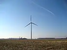
Ohio's first utility-sized wind farm is located along U.S. Route 6 just west of the city limits.[38] There are four turbines that are each 257 feet (78 m) tall. These turbines generate up to 7.2 megawatts of power, which is enough to supply electricity for some 3,000 residents. Located about six miles (10 km) from the city, the turbines can be seen for miles and have become a local attraction.[39] At the site of the turbines, a solar-powered kiosk provides information for visitors, including current information on wind speeds and the amount of energy being produced by the turbines.
Through the city's Municipal Utilities office, residents can request that their power come from green energy. As of March 1, 2014, the current power cost premium is $.007 per KWH.[40]
However, Bowling Green's green credentials were damaged in 2008, when the city signed a power contract with AMP-Ohio to help build a 960-megawatt coal-fired power plant in Meigs County, Ohio. Several large environmental groups, including Sierra Club, the Natural Resources Defense Council, and the Ohio Environmental Council, opposed the building of a coal-fired power plant due to the pollution it would cause. In late 2009, AMP canceled the project, citing an estimated 37% increase in cost to more than $3 billion.[41]
In January 2017 a new 165 acre, 20 megawatt solar plant began operation on the edge of the city.[42] The plant experienced a slight disruption from the Solar eclipse of August 21, 2017[43]
Economy
.jpg.webp)
LifeFormations, a mechatronics company, is based in Bowling Green.[44] They have made animatronics based on licensed properties such as Shrek for theme parks such as Universal Studios Florida.[45]
Lubrizol maintains a soap and surfactant production plant in Bowling Green.[46][47] The Bowling Green plant opened in 1994 and was expanded in 2013.[48]
Aliquantum International maintains a sales office in Bowling Green.[49] The company licences characters from the Japanese company San-X for local markets, such as Rilakkuma.[50]
Poggemeyer Design Group, an architecture and engineering firm, maintains its headquarters in Bowling Green.[51]
Notable people
- John Barnes, science-fiction writer[52]
- Theresa Gavarone, Ohio Senator
- Alissa Czisny, figure skater, 2009 and 2011 U.S. champion
- William Easterly, economist / professor at NYU
- Randy Gardner, Chancellor, Ohio Department of Higher Education
- Scott Hamilton, figure skater, 1984 Olympic champion; television commentator
- Chris Hoiles, retired Major League Baseball player
- Doug Mallory, NFL assistant coach
- Mike Mallory, NFL assistant coach
- Paul Pope, alternative comic book writer/artist
- Andy Tracy, first baseman for the Philadelphia Phillies, alumnus of Bowling Green High School and Bowling Green State University
- Dave Wottle, runner, 1972 Olympic gold medalist
- Cara Zavaleta, reality TV personality and model
- Andrew Ogg, mathematician
- Miranda May, actress on Disney Channel's Bunk'd
- Gary Wright, pilot
References
- "Archived copy". Archived from the original on 2005-12-20. Retrieved 2006-12-31.CS1 maint: archived copy as title (link) Retrieved December 31, 2006.
- "The City of Bowling Green, Ohio". Archived from the original on December 20, 2005. Retrieved December 31, 2006.
- https://www.bgohio.org/departments/elected-officials/mayor-2/ Retrieved January 3, 2020.
- http://www.bgohio.org/departments/municipal-administrator/ Retrieved April 3, 2016.
- "2019 U.S. Gazetteer Files". United States Census Bureau. Retrieved July 27, 2020.
- "American FactFinder - Results". United States Census Bureau. Archived from the original on 2020-02-12. Retrieved 2013-01-06.
- "Population and Housing Unit Estimates". Retrieved May 21, 2020.
- "CPH-T-5. Annual Estimates of the Population of Combined Statistical Areas: April 1, 2010 to July 1, 2012". census.gov. Archived from the original on 17 May 2013. Retrieved 14 February 2014.
- "U.S. Census website". United States Census Bureau. Retrieved 2008-01-31.
- "US Board on Geographic Names". United States Geological Survey. 2007-10-25. Retrieved 2008-01-31.
- "Find a County". National Association of Counties. Archived from the original on 2011-05-31. Retrieved 2011-06-07.
- "TOLEDO METROPOLITAN AREA COUNCIL OF GOVERNMENTS MEMBERSHIP" (PDF). Archived from the original (PDF) on 22 February 2014. Retrieved 14 February 2014.
- Overman, William Daniel (1958). Ohio Town Names. Akron, OH: Atlantic Press. p. 17.
- The History of Bowling Green State University. p. 16. Retrieved 27 August 2020.
- Early History of Bowling Green, Ohio Archived 2011-12-14 at the Wayback Machine
- "National Register Information System". National Register of Historic Places. National Park Service. July 9, 2010.
- McLaughlin, Jan Larson. "Wood County had its share of murders & robberies in 'wild west' past – BG Independent News". Retrieved 11 November 2019.
- "Bee Gee News June 15, 1944". BG News (Student Newspaper). 15 June 1944. Retrieved 24 November 2019.
- "The BG News April 2, 1975". BG News (Student Newspaper). 2 April 1975. Retrieved 25 November 2019.
- Claiborne, William; Phillips, Don (16 May 2001). "Railroad Worker Jumps Into, Stops Runaway Train". Washington Post. Retrieved 12 November 2019.
- "US Gazetteer files 2010". United States Census Bureau. Archived from the original on 2012-01-25. Retrieved 2013-01-06.
- "Census of Population and Housing". Census.gov. Retrieved June 4, 2015.
- U.S. Census, United States Census Bureau. "Quick Facts". United States Census Bureau. United States. Retrieved 28 November 2016.
- "Profile of General Population and Housing Characteristics: 2010". American FactFinder. United States Census Bureau. Archived from the original on 12 February 2020. Retrieved 7 February 2017.
- "Archived copy". Archived from the original on 2016-05-01. Retrieved 2016-05-03.CS1 maint: archived copy as title (link) Retrieved April 3, 2016
- "Wood County Fair Beginning Sunday". Toledo Blade. July 30, 1982.
- Montessori preps for celebration - Sentinel-Tribune | Sentinel-Tribune | Sentinel-Tribune | Montessori, School, Comments, Staff
- "Medalist's return warms fans' hearts - and Hamilton's". Toledo Blade. Archived from the original on 2013-02-04.
- "Bowling Green City Schools :: Schools". Retrieved 25 February 2014.
- Alusheff, Alex (7 October 2013). "Bowling Green City Council buys Ridge Elementary to convert to park". The BG News. Retrieved 25 February 2014.
- Rice, Laura (17 May 2011). "BG City Schools to close two schools, cut no teachers". North West Ohio. Archived from the original on 5 March 2014. Retrieved 25 February 2014.
- NOLAN ROSENKRANS (10 September 2014). "Local college enrollment declines". Toledo Blade.
- "Hours & Locations". Wood County District Public Library. Archived from the original on 3 March 2018. Retrieved 3 March 2018.
- "Public Transportation".
- "Shuttle Routes". Bowling Green State University. Archived from the original on 2017-09-07. Retrieved 2018-12-08.
- Wood County Park District: Slippery Elm Trail Archived 2014-03-01 at the Wayback Machine
- "Wood County Park District". Archived from the original on 1 March 2014. Retrieved 25 February 2014.
- "Ohio's First Commercial Wind Farm". Green Energy Ohio. Archived from the original on 2007-11-10. Retrieved 2008-12-15.
- "Ohio gov blows hard with wind-powered energy". Environment Ohio. 2008-01-12. Archived from the original on 2011-07-26. Retrieved 2008-12-15.
- http://www.bgohio.org/wp-content/uploads/2014/06/BGMU-Electric-Rate-Schedules-Effective-3-1-14.pdf Retrieved April 3, 2016
- "AMP-Ohio abandons plans for coal plant". American City Business Journals. 2009-11-25. Retrieved 2011-01-05.
- McLaughlin, Jan Larson. "BG plugs into power from new solar field – BG Independent News". Retrieved 11 November 2019.
- McLaughlin, Jan Larson. "BG solar field energy output dropped during eclipse – BG Independent News". Retrieved 11 November 2019.
- "LifeFormations aims to get your attention with life-sized figures". Toledo Blade. Retrieved 25 November 2019.
- Brigante, Ricky (20 November 2013). "Best of IAAPA Expo 2013: Unique rides, games, and flavors fill Orlando attractions convention with new amusements". Inside the Magic. Retrieved 6 December 2019.
- "Lubrizol to expand its B.G. plant". Toledo Blade. Retrieved 25 November 2019.
- "Tensions Surface". HAPPI. Retrieved 6 December 2019.
- "Lubrizol to expand its B.G. plant". Toledo Blade. Retrieved 6 December 2019.
- "Contact". Aliquantum International. 19 December 2018. Retrieved 6 December 2019.
- "Japanese retailer known for its 'stress-free' bear will open first U.S. store in suburban Tampa". www.bizjournals.com. Retrieved 6 December 2019.
- McLaughlin, Jan. "Poggemeyer has been building up region for 50 years – BG Independent News". Retrieved 6 December 2019.
- "Foreword," in Barnes, John. Apostrophes and Apocalypses. NYC:Tor 1998 p. 9
External links
| Wikimedia Commons has media related to Bowling Green, Ohio. |
| Wikivoyage has a travel guide for Bowling Green, Ohio. |
| Wikisource has the text of the 1911 Encyclopædia Britannica article Bowling Green (Ohio). |
- Official website
- Bowling Green Convention & Visitors Bureau Website
- Bowling Green Chamber of Commerce
Municipalities and communities of Wood County, Ohio, United States | ||
|---|---|---|
| Cities | 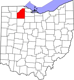 Map of Ohio highlighting Wood County | |
| Villages | ||
| Townships | ||
| CDPs | ||
| Other unincorporated communities | ||
| Footnotes | ‡This populated place also has portions in an adjacent county or counties | |
| ||
| Authority control |
|---|