Brahin District
Brahin District or Brahinski Rajon (Belarusian: Брагінскі раён, Russian: Брагинский район, Bragin District), is a district of Gomel Region, in Belarus. Its administrative seat is the small town of Brahin.
Brahin District
| |
|---|---|
 Flag | |
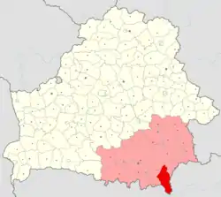 Location of Brahin Raion within Gomel Region | |
| Coordinates: 51°47′N 30°16′E | |
| Country | |
| Region | |
| Seat | Brahin |
| Government | |
| • Ispolkom | ? |
| Area | |
| • Total | 1,960.46 km2 (756.94 sq mi) |
| Population (2016)[1] | |
| • Total | 12,128 |
| Website | Official website |
Geography
The district includes the towns of Brahin and Kamaryn, 14 rural councils (Selsovets), and several villages. Following the 1986 Chernobyl disaster, it is partially included in the Polesie State Radioecological Reserve.[2][3] To the south of Kamaryn is situated the southernmost point of Belarus.[4]
References
- (in Russian) Source: BelStat 2016 Archived 2017-07-30 at the Wayback Machine
- Polesie Radio-ecological Zapovednik Archived 2016-07-31 at the Wayback Machine (APB BirdLife Belarus)
- 253459229 Polesie State Radioecological Reserve on OpenStreetMap
- "Coordinates of the extreme points of the state frontier. Main Geographic Characteristics of the Republic of Belarus". Land of Ancestors. 2011. Archived from the original on 21 September 2013. Retrieved 9 September 2013.
This article is issued from Wikipedia. The text is licensed under Creative Commons - Attribution - Sharealike. Additional terms may apply for the media files.