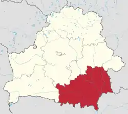
Gomel Region
Gomel Region or Gomel Oblast or Homyel Voblasts (Belarusian: Го́мельская во́бласць, Homielskaja vobłasć, Russian: Гомельская область, Gomelskaya oblast) is one of the regions of Belarus. Its administrative center is Gomel.
Gomel Region
Gomel Oblast, Homyel Voblasts | |
|---|---|
 Flag  Coat of arms | |
 | |
| Administrative center | Gomel |
| Largest cities | Gomel – 481,200 Mazyr – 111,800 Zhlobin – 72,800 |
| Districts | 21 Cities – 17 Urban localities – 278 Villages – 2,608 |
| City raions | 4 |
| Area | |
| • Total | 40,361.66 km2 (15,583.72 sq mi) |
| Population (2013) | |
| • Total | 1,426,674 |
| • Density | 35/km2 (92/sq mi) |
| ISO 3166 code | BY-HO |
| HDI (2017) | 0.803[1] very high · 4th |
| Website | www.gomel-region.by |
The total area of the region is 40,400 square kilometres (15,600 sq mi), the population in 2011 stood at 1,435,000 with the number of inhabitants per km2 at 36.[2]
Important cities within the region include: Gomel, Mazyr, Zhlobin, Svietlahorsk, Rechytsa, Kalinkavichy, Rahachow, Dobrush.
Both the Gomel Region and the Mogilev Region suffered severely after the Chernobyl nuclear reactor catastrophe.[3] The Gomel Province borders the Chernobyl Exclusion Zone in places, and parts of it is designated as mandatory or voluntary resettlement areas as a result of the radioactive contamination.[4]
Administrative territorial entities
Gomel Region comprises 21 districts and 2 city municipalities. The districts have 278 selsovets, and 17 cities and towns.
Districts of Gomel Region
|
Cities and towns
| English | Belarusian | Pop. |
|---|---|---|
| Gomel | Belarusian: Го́мель | 481,200 |
| Mazyr | Belarusian: Мазы́р | 111,800 |
| Zhlobin | Belarusian: Жло́бін | 72,800 |
| Svietlahorsk | Belarusian: Светлаго́рск | 71,700 |
| Rechytsa | Belarusian: Рэчыца | 66,200 |
| Kalinkavichy | Belarusian: Калінкавічы | 37,900 |
| Rahachow | Belarusian: Рагачоў | 34,700 |
| Dobrush | Belarusian: Добруш | 19,300 |
| Zhytkavichy | Belarusian: Жыткавічы | 16,900 |
| Khoyniki | Belarusian: Хойнікі | 14,200 |
| Pietrykaw | Belarusian: Петрыкаў | 10,600 |
| Yel’sk | Belarusian: Ельск | 10,000 |
| Buda-Kashalyova | Belarusian: Буда-Кашалёва | 9,500 |
| Naroulia | Belarusian: Нароўля | 8.200 |
| Vietka | Belarusian: Ветка | 7,800 |
| Chachersk | Belarusian: Чачэрск | 7,700 |
| Vasilievichy | Belarusian: Васілевічы | 4,500 |
| Brahin | Belarusian: Брагін | 3,700 |
| Turov | Belarusian: Ту́раў | 3,200 |
City municipalities: Gomel, Mazyr.
Geography
Pripyatsky National Park covers 2% of the territory of the region. Eleven wildlife preserves of national importance cover 2.1% of the region.[5]
The extreme southern point of Belarus is located in Gomel Region, on the Dnieper River to the south of the urban-type settlement of Kamaryn, Brahin District.[6]
The 3rd largest lake in Belarus, Lake Chervonoye, is located in Gomel Region, Zhytkavichy District.[7]
Gomel Region borders Mogilev Region on the north, Brest Region on the west, Russia (Bryansk Oblast) on the east and Ukraine (Chernihiv Oblast, Kyiv Oblast and Zhytomyr Oblast) on the south and southeast.
Demography
.png.webp) Belarusians in the region>95%90–95%85—90%<85%
Belarusians in the region>95%90–95%85—90%<85%.png.webp) Russians in the region>10%8–10%5–8%2–5%<2%
Russians in the region>10%8–10%5–8%2–5%<2%.png.webp) Ukrainians in the region>3%2–3%1–2%<1%
Ukrainians in the region>3%2–3%1–2%<1%
Economy
The processing industry is represented by alcohol, alcoholic beverage, wine, beer and soft drinks, vegetable-drying and canning industries. Mazyr is home to one of Belarus' major oil refineries.
Transport
Gomel Region is a major transport hub. Major railway junctions include Gomel, Zhlobin, and Kalinkavichy. Gomel is located at the intersection of the highways 95E Odessa – Kyiv – St. Petersburg, Bakhmach – Vilnius, and M10 Bryansk – Brest. River transport is also common in the region with regular navigation on the Pripyat, Dnieper and Berezina rivers.
Tourism
The number of travel agencies in Gomel Region has grown from 21 in 2000 to 54 in 2010.[8][9] Main tourist destinations of the region are Pripyatsky National Park and Gomel.
References
- "Sub-national HDI - Area Database - Global Data Lab". hdi.globaldatalab.org. Retrieved 2018-09-13.
- "Main Geographic Characteristics of the Republic of Belarus. Territory and population density of Belarus by region as of January 1, 2011". Land of Ancestors. The Scientific and Production State Republican Unitary Enterprise “National Cadastre Agency” of the State Property Committee of the Republic of Belarus. 2011. Retrieved 24 September 2013.
- http://commons.wikimedia.org/wiki/File:Chernobyl_radiation_map_1996.svg
- Mould, Richard Francis (2000-05-01). Chernobyl Record: The Definitive History of the Chernobyl Catastrophe. CRC Press. ISBN 9780750306706.
- "Nature reserves and national parks, wildlife preserves and nature sanctuaries". Land of Ancestors. Data of the Ministry of Natural Resources and Environmental Protection of the Republic of Belarus. 2011. Retrieved 29 November 2013.
- "Main Geographic Characteristics of the Republic of Belarus. Coordinates of the extreme points of the state frontier". Land of Ancestors. The Scientific and Production State Republican Unitary Enterprise “National Cadastre Agency” of the State Property Committee of the Republic of Belarus. 2011. Retrieved 20 September 2013.
- "Main characteristics of the largest lakes of Belarus". Land of Ancestors. Data of the Research Laboratory for Lake Study of the Belarus State University. 2011. Retrieved 29 September 2013.
- Ministry of Sports and Tourism of the Republic of Belarus. (2011). "Number of organizations engaged in tourist activities in 2010 in Belarus". Land of Ancestors. National Statistical Committee of the Republic of Belarus. Retrieved 9 October 2013.
- Ministry of Sports and Tourism of the Republic of Belarus. (2011). "Number of organisations engaged in tourist activities in Belarus by region". Land of Ancestors. National Statistical Committee of the Republic of Belarus. Retrieved 9 October 2013.
External links
- Gomel Oblast Executive Committee
- Gomel Regional Executive Committee (Archive) (2004)
- Homel Region: Epicentre Of Troubles That Bore Celebrities
| Districts (raions) | | |
|---|---|---|
| Cities | ||
| Authority control |
|---|