Brandon, Colorado
Brandon is an unincorporated community and a census-designated place (CDP) located in Kiowa County, Colorado, United States. The population of the Brandon CDP was 21 at the United States Census 2010.[6] Kiowa County governs the unincorporated community. The Sheridan Lake post office (Zip Code 81071) serves Brandon postal addresses.[5]
Brandon, Colorado | |
|---|---|
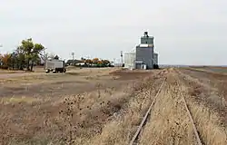 Brandon in 2015. | |
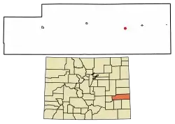 Location of the Brandon CDP in Kiowa County, Colorado. | |
 Brandon Location of the Brandon CDP in the United States. | |
| Coordinates: 38°26′47″N 102°26′28″W[1] | |
| Country | |
| State | |
| County | Kiowa County |
| Established | late 1887[2][3] |
| Government | |
| • Type | unincorporated community |
| Area | |
| • Total | 0.117 sq mi (0.304 km2) |
| • Land | 0.117 sq mi (0.304 km2) |
| • Water | 0.000 sq mi (0.000 km2) |
| Elevation | 3,924 ft (1,196 m) |
| Population (2010) | |
| • Total | 21 |
| • Density | 179/sq mi (69/km2) |
| Time zone | UTC-7 (MST) |
| • Summer (DST) | UTC-6 (MDT) |
| ZIP Code[5] | 81071 |
| Area code(s) | 719 |
| GNIS feature[4] | Brandon CDP |
History
The town of Brandon was established in late 1887.[2][3] The Brandon post office opened on May 19, 1888, and closed on February 28, 1963.[7]
Geography
Brandon is located in eastern Kiowa County. Colorado State Highway 96 passes along the north side of the community, leading west 20 miles (32 km) to Eads, the county seat, and east 8 miles (13 km) to Sheridan Lake.
The Brandon CDP has an area of 75 acres (0.304 km2), all land.[1]
Demographics
The United States Census Bureau initially defined the Brandon CDP for the United States Census 2010.
| Year | Pop. | ±% |
|---|---|---|
| 2010 | 21 | — |
| 2020 | — | |
| Source: United States Census Bureau | ||
See also
- Outline of Colorado
- State of Colorado
- Colorado cities and towns
- Colorado counties
- Sand Creek Massacre National Historic Site
References
- "State of Colorado Census Designated Places - BAS20 - Data as of January 1, 2020". United States Census Bureau. Retrieved December 22, 2020.
- Eichler, Geo. R. (1977). Colorado Place Names. 77-089726: Johnson Publishing Company.CS1 maint: location (link)
- "KIOWA COUNTY: THE HIGH PLAINS OF SOUTHEAST COLORADO". Archived from the original (MS Word) on 2006-10-23. Retrieved 2007-09-30.
- "U.S. Board on Geographic Names: Domestic Names". United States Geological Survey. Retrieved December 22, 2020.
- "Look Up a ZIP Code". United States Postal Service. Retrieved December 22, 2020.
- "2010: DEC Summary File 1". United States Census Bureau. Retrieved December 22, 2020.
- Bauer, William H.; James L. Ozment; John H. Willard (1990). Colorado Post Offices 1859-1989. 90-34759: The Colorado Railroad Museum. ISBN 0-918654-42-4.CS1 maint: location (link)
External links
Municipalities and communities of Kiowa County, Colorado, United States | ||
|---|---|---|
| Towns | 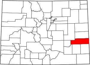 Map of Colorado highlighting Kiowa County | |
| CDPs | ||
| Unincorporated communities | ||
| ||
