Branston, Leicestershire
Branston is a village in the civil parish of Croxton Kerrial and Branston, in Leicestershire, England. It lies 1 mile (1.6 km) north of the A607 road, 7 miles (11 km) south-west of Grantham and 7 miles north-east of Melton Mowbray. Branston is at the southern edge of the Vale of Belvoir, 3 miles (5 km) south-west of Belvoir Castle. Knipton Reservoir is 700 yards (640 m) to the north. The population is included in the civil parish of Croxton Kerrial.
| Branston | |
|---|---|
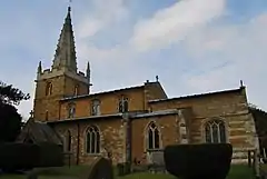 St Guthlac's Church, Branston | |
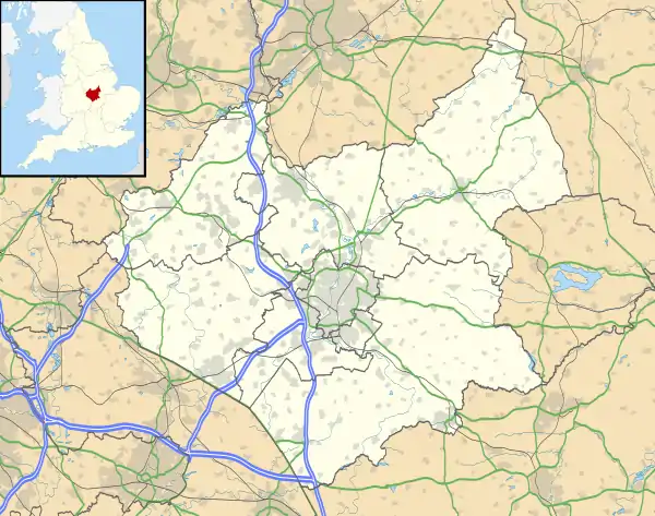 Branston Location within Leicestershire | |
| OS grid reference | SK810293 |
| • London | 95 mi (153 km) S |
| District | |
| Shire county | |
| Region | |
| Country | England |
| Sovereign state | United Kingdom |
| Post town | GRANTHAM |
| Postcode district | NG32 |
| Dialling code | 01476 |
| Police | Leicestershire |
| Fire | Leicestershire |
| Ambulance | East Midlands |
| UK Parliament | |
History
According to A Dictionary of British Place Names, Branston could be "a farmstead or a village of a man called Brant" – 'Brant' from an Old English person name and 'ton' for "enclosure, farmstead, village, manor, [or] estate".[1]
In the 1086 Domesday account Branston is referred to as "Brantestone"[2] in the Framland Hundred of north-east Leicestershire. It had 21 households, 10 villagers, 1 smallholder 6 freemen and 4 slaves, with a meadow of 16 acres (0.1 km2) and 2 mills. In 1066 Leofnoth of Branston was Lord of the Manor; after 1086 this transferred to Ralph of Kimcote, with the Bishop of Lincoln becoming Tenant-in-chief.[3]
The Grade II* listed Anglican parish church is dedicated to St Guthlac, originating in the 13th century with alterations up the 15th. New chancel and nave roofs were added in 1895-96 by George Frederick Bodley and Thomas Garner, Gothic Revival architects.[4] Further Grade II listed buildings are three 18th-century farmhouses,[5][6][7] the early 19th-century Old Rectory,[8] and the Village Hall dating from 1843.[9]
Quarrying
Iron ore was quarried in two areas near Branston. The first quarry was north of the village on the east side of the Barkestone Road. Ore was first obtained in 1915 and the quarrying worked its way southwards and then back northwards again a little to the east back to a point close to where it started. The quarries closed in 1949. The ore was taken by narrow-gauge tramway to the tipping dock at the terminus of the Great Northern Railway's Eaton Branch Railway from where it was taken away by railway. The quarries were worked by hand with the aid of explosives at first. A steam digger was introduced in 1923 and diesel diggers in 1936. The tramway was worked by steam locomotives.[10]
The second set of quarries were to the west of the village on either side of the Eaton Road. Quarrying began on the south side of the road close to Eaton Grange in 1922 and finished close to the road leading to Lings Hill in 1951. In 1952, new quarries were opened on the north side of the road, working towards the village. The last ore was obtained in 1957. A tramway bridge had been constructed on the road to Lings Hill ready for a new quarry east of the road to be started but this quarry was never started. Quarrying was first done with the aid of steam diggers but diesel machines were introduced in 1936. The ore was taken away by a second narrow-gauge tramway via Eastwell and transhipped onto the main railway near Harby.[11]
References
- Mills, Anthony David (2003); A Dictionary of British Place Names, pp.73, 525, Oxford University Press, revised edition (2011). ISBN 019960908X
- "Documents Online: Branston, Leicestershire", Great Domesday Book, Folio: 231r; The National Archives. Retrieved 4 July 2012
- "Branston", Domesdaymap.co.uk. Retrieved 4 July 2012
- Historic England. "Church of St Guthlac (1188319)". National Heritage List for England. Retrieved 4 July 2012.
- Historic England. "Hall Farmhouse (1294822)". National Heritage List for England. Retrieved 4 July 2012.
- Historic England. "Lings Farmhouse and Attached Stable Range (1075056)". National Heritage List for England. Retrieved 4 July 2012.
- Historic England. "Wilds Farmhouse (1075055)". National Heritage List for England. Retrieved 4 July 2012.
- Historic England. "The Old Rectory (1360919)". National Heritage List for England. Retrieved 4 July 2012.
- Historic England. "Village Hall (1075054)". National Heritage List for England. Retrieved 4 July 2012.
- Tonks, Eric (1992). The Ironstone Quarries of the Midlands Part 9: Leicestershire. Cheltenham: Runpast Publishing. p. 93 -110. ISBN 1-870-754-085.
- Tonks, Eric (1992). The Ironstone Quarries of the Midlands Part 9: Leicestershire. Cheltenham: Runpast Publishing. p. 131-145. ISBN 1-870-754-085.
External links
 Media related to Branston, Leicestershire at Wikimedia Commons
- "Branston (Branston by Belvoir or Branstone)", Genuki.org.uk. Retrieved 4 July 2012
- "Branston Leicestershire", A Vision of Britain through Time. Retrieved 4 July 2012
- Croxton Kerrial and Branston Parish Council
- "Croxton Kerrial CP (Parish)"; United Kingdom Census 2001, Statistics.gov.uk. Retrieved 4 July 2012
England Portal | |
| Unitary authorities | |
| Boroughs or districts | |
| Major settlements | |
| Topics | |