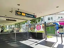
Bras Basah MRT station
Bras Basah MRT station is an underground Mass Rapid Transit (MRT) station on the Circle line (CCL) located in the Museum planning area, Singapore. It is underneath Bras Basah Road, bordering Waterloo Street and Queen Street. Located next to the Singapore Management University (SMU), this station is in close proximity to Bencoolen station on the Downtown line (DTL), even though they are not directly connected as an interchange. The station is also within walking distance to the National Museum of Singapore, the Singapore Art Museum, Peranakan Museum and the School of the Arts.
CC2
Bras Basah 百胜 பிராஸ் பாசா Bras Basah | |||||||||||
|---|---|---|---|---|---|---|---|---|---|---|---|
| Mass Rapid Transit (MRT) station | |||||||||||
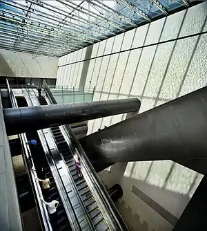 Escalators in Bras Basah station underneath the reflective pool, which is a key feature of the station. | |||||||||||
| Location | 65 Bras Basah Road Singapore 189561[1][2] | ||||||||||
| Coordinates | 1°17′49″N 103°51′02″E | ||||||||||
| Operated by | SMRT Trains Ltd (SMRT Corporation) | ||||||||||
| Line(s) | |||||||||||
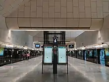
| Platforms | 2 (1 island platform) | ||||||||||
| Tracks | 2 | ||||||||||
| Connections | Bus Taxi | ||||||||||
| Construction | |||||||||||
| Structure type | Underground | ||||||||||
| Depth | 35 metres | ||||||||||
| Platform levels | 1 | ||||||||||
| Parking | Yes (Singapore Management University) | ||||||||||
| Disabled access | Yes | ||||||||||
| History | |||||||||||
| Opened | 17 April 2010 | ||||||||||
| Electrified | Yes | ||||||||||
| Previous names | Museum[3] | ||||||||||
| Services | |||||||||||
| |||||||||||
| Location | |||||||||||
_map.svg.png.webp) Bras Basah Bras Basah station in Singapore | |||||||||||
Initially announced as part of the Marina MRT line, it was later incorporated into the CCL Stage 1. Along with the other stations on Stages 1 and 2 of the CCL, the station started operations on 17 April 2010. The design of the station by WOHA was commissioned through the Marina line Architectural Design Competition and was awarded the "Best Transport Building" in 2009 at the World Architecture Festival.
History
Contract 825 for the design and construction of Bras Basah station and associated tunnels was awarded to Shanghai Tunnel Engineering Co. (Singapore) Pte Ltd and a joint venture with Woh Hup and NCC at a sum of S$343.94 million (US$191.93 million) on 19 December 2001. The contract also included the construction of the Dhoby Ghaut, Esplanade and Promenade stations.[4][5]
To facilitate the construction, on 10 June 2002, part of Bras Basah Road had to be temporarily realigned.[6] On 15 March 2003, the junctions of Queen Street/Bras Basah Road and Waterloo Street/Bras Basah Road were temporarily closed and the service road adjacent to Oxford Hotel was converted into one-way road in the direction from Queen Street to Waterloo Street.[7] In 2007, the diverted roads have been reinstated as the station undergoes architectural, electrical and mechanical works.[8] On 17 April 2010, the station opened as part of Stages 1 and 2 of the CCL.[9][10]
Station details
Etymology
The name Bras Basah (Modern Spelling: Beras Basah) means "wet rice" in Malay – beras means harvested rice with husk removed, and basah means wet.[11] Before the station was built, it was named Museum. Later on in 2005, it was renamed to Bras Basah, as the name is well-known and reflects the area's heritage.[3]
Services
Track layout | ||||||||||||||||||||||||||||||||||||||||||||||||||||||||||||||||||||||
|---|---|---|---|---|---|---|---|---|---|---|---|---|---|---|---|---|---|---|---|---|---|---|---|---|---|---|---|---|---|---|---|---|---|---|---|---|---|---|---|---|---|---|---|---|---|---|---|---|---|---|---|---|---|---|---|---|---|---|---|---|---|---|---|---|---|---|---|---|---|---|
| ||||||||||||||||||||||||||||||||||||||||||||||||||||||||||||||||||||||
The station serves the Circle line, situated between the Dhoby Ghaut and Esplanade stations. The station code is CC2 on official maps.[12] The station operates daily between 5:39 am (6:06 am on Sundays and Public Holidays) and 12:03 am.[13] Train frequencies varies from 5 to 7 minutes depending on peak hours.[14]
Architecture
The station is 35 metres (115 ft) below ground and was the deepest station when it first opened[15] until the completion of the DTL platforms at Promenade station, which has a depth of 42 metres (138 ft).[16] The station was constructed deep underground as the line has to cross underneath the East West Line beneath Victoria Street to reach the station. It is also the station with the longest escalator in the MRT network at 41 metres (135 ft), stretching from the ticket concourse to the transfer level and takes approximately one minute to travel.[15]
The station design by WOHA resolves two conditions needed for the station: allowing a visual connection to the exterior to enhance the travel experience for the commuters, and enabling the station to blend into the landscape in the historic district and park location. A reflection pool, which also acts as the station roof, allows skylight to enter the station, and functions as a landscape element on the surface. With skylight entering the station, minimal artificial light is required for the station during the day. The natural light improves way-finding and safety for the commuters.[17] The ventilation shafts of the station blends into the landscape, avoiding obstruction of the view across the site to the surrounding civic buildings.[15][18]
The station design was commissioned through the Marina line Architectural Design Competition jointly organised by the Land Transport Authority (LTA) and the Singapore Institute of Architects (SIA). At the 2001 SIA Awards, the SIA awarded LTA the prize for ‘Excellence in Architectural Design Competitions’.[15] In 2009, the station was awarded the "Best Transport Building" at the World Architecture Festival, on the basis that the design gives "precedence to the surrounding, historically important, colonial structures, creating a piazza-like urban space to the station underneath" and noted the design's functionality to allow natural light into the station.[15][19] The station later won the Award for International Architecture at the AIA's (American Institute of Architects) 2010 National Architecture Awards.[17] In addition, it won the Chicago Athenaeum and the European Centre for Architecture Art Design and Urban Studies and International Architecture Awards in 2011.[20]
Public artwork
A video work The Amazing Neverending Underwater Adventures! by Tan Kai Syng is displayed at the station, commissioned as part of the MRT network's Art-in-Transit programme. In the video, the protagonist, Desyphus, a “Perpetual Commuter”, goes on a quest on board the Circle Line, in which she battles "Life’s Big Quirks, Ecstasies and Agonies" along the way. The video also "explores" sites familiar to commuters, creating smaller tales "which adds to the (hi-)stories (in addition to the museums surrounding the station) of the Bras Basah area." The video is projected on the wall below the station’s roof takes commuters through themes of travel, time, memory and the train line.[21][22]
References
- "Location View of 65 Bras Basah Road, 189561". SG & Singapore Map! Powered by Streetdirectory.com. 21 August 2020. Retrieved 21 August 2020.
- "Map of Bras Basah MRT Station, 65 Bras Basah Road Singapore 189561". yoursingaporemap.com (in Indonesian). Retrieved 21 August 2020.
- "Annex A Finalised Names For Circle Line (CCL) Stages 1–3 Stations". www.lta.gov.sg. Archived from the original on 18 December 2006.
- "Project LTA C825 | STECS". stecs2. Retrieved 27 April 2020.
- "LTA Annual Safety Award Convention 2005". www.lta.gov.sg. Archived from the original on 30 November 2009.
- "Temporary Traffic Diversion And Road Realignment For Construction Of Circle Line Stage 1". www.lta.gov.sg. Archived from the original on 23 April 2010.
- "Changes To Traffic Scheme For Circle Line (Stage One) Construction". www.lta.gov.sg. 13 March 2003. Archived from the original on 23 April 2010.
- "Circle Line On Track For Completion". 14 September 2007. Archived from the original on 19 June 2012.
- "Welcome Remarks By Mr Raymond Lim At The Opening Of The Circle Line From Dhoby Ghaut To Bartley on 16 April 2010". www.mot.gov.sg. Archived from the original on 1 May 2020. Retrieved 1 May 2020.
- "Circle Line from Bartley to Dhoby Ghaut to Open 17 April". www.lta.gov.sg. Archived from the original on 21 June 2011. Retrieved 26 January 2010.
- "Your views on names for Circle Line Stages 1 to 3 Stations". www.lta.gov.sg. 26 March 2004. Archived from the original on 7 April 2012.
- "MRT System Map" (PDF). Land Transport Authority (LTA). Retrieved 23 August 2020.
- "SMRT > Journey with Us > Trains > NetworkMap > BrasBasah". SMRT Corporation Ltd. 4 February 2015. Retrieved 22 August 2020.
- "Transport Tools - MRT/LRT". LTA. 6 May 2020. Archived from the original on 1 November 2019. Retrieved 19 June 2020.
- "Factsheet Bras Basah Station" (PDF). www.lta.gov.sg. 16 April 2010. Archived from the original (PDF) on 19 February 2013. Retrieved 30 March 2016.
- "Downtown Line | Press Room | Land Transport Authority". www.lta.gov.sg. Archived from the original on 12 August 2014.
- "Bras Basah Mass Rapid Transit Station, Singapore". ArchitectureAU. Archived from the original on 10 January 2018. Retrieved 17 July 2020.
- "Bras Basah Mass Rapid Transit (MRT) Station WOHA". World-Architects. Archived from the original on 7 June 2020. Retrieved 17 July 2020.
- "Bras Basah Mass Rapid Transit Station". World Buildings Director. Archived from the original on 20 February 2012. Retrieved 11 October 2013.
- "The International Architectural Awards – 2011 Archive" (PDF). The Chicago Athenaeum. Archived (PDF) from the original on 17 July 2020.
- "LTA | Getting Around | Public Transport | A Better Public Transport Experience | Art in Transit". www.lta.gov.sg. Archived from the original on 21 April 2020. Retrieved 17 July 2020.
- "Circle Line Art" (PDF). www.lta.gov.sg. Archived from the original (PDF) on 11 February 2017.
External links
- Official website
 Media related to Bras Basah MRT Station at Wikimedia Commons