Bridgewater, Vermont
Bridgewater is a town in Windsor County, Vermont, United States. The population was 936 at the 2010 census.[3] Bridgewater contains the hamlets of Bridgewater Village, Bridgewater Corners, West Bridgewater, and Bridgewater Center (formerly called Briggs).
Bridgewater, Vermont | |
|---|---|
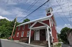 The Bridgewater Historical Society building | |
 Location in Windsor County and the state of Vermont. | |
 Bridgewater, Vermont Location in the United States | |
| Coordinates: 43°37′10″N 72°40′19″W | |
| Country | United States |
| State | Vermont |
| County | Windsor |
| Chartered | 1761 |
| Settled | 1779 |
| Organized | 1785 |
| Area | |
| • Total | 49.5 sq mi (128.3 km2) |
| • Land | 49.4 sq mi (128.0 km2) |
| • Water | 0.2 sq mi (0.4 km2) |
| Elevation | 1,040 ft (317 m) |
| Population (2010) | |
| • Total | 936 |
| • Density | 19/sq mi (7.3/km2) |
| Time zone | UTC-5 (Eastern (EST)) |
| • Summer (DST) | UTC-4 (EDT) |
| ZIP code | 05034 |
| Area code(s) | 802 |
| FIPS code | 50-08275[1] |
| GNIS feature ID | 1462050[2] |
Geography
According to the United States Census Bureau, the town has a total area of 49.5 square miles (128.3 km2), of which 49.4 square miles (128.0 km2) is land and 0.15 square miles (0.4 km2), or 0.27%, is water.[4] The Ottauquechee River flows west to east through the town.[5] U.S. Route 4 follows the river, connecting Woodstock and White River Junction to the east with Rutland to the west.
Demographics
| Historical population | |||
|---|---|---|---|
| Census | Pop. | %± | |
| 1790 | 293 | — | |
| 1800 | 781 | 166.6% | |
| 1810 | 1,125 | 44.0% | |
| 1820 | 1,125 | 0.0% | |
| 1830 | 1,311 | 16.5% | |
| 1840 | 1,363 | 4.0% | |
| 1850 | 1,311 | −3.8% | |
| 1860 | 1,292 | −1.4% | |
| 1870 | 1,141 | −11.7% | |
| 1880 | 1,084 | −5.0% | |
| 1890 | 1,124 | 3.7% | |
| 1900 | 972 | −13.5% | |
| 1910 | 874 | −10.1% | |
| 1920 | 808 | −7.6% | |
| 1930 | 741 | −8.3% | |
| 1940 | 895 | 20.8% | |
| 1950 | 903 | 0.9% | |
| 1960 | 776 | −14.1% | |
| 1970 | 783 | 0.9% | |
| 1980 | 867 | 10.7% | |
| 1990 | 895 | 3.2% | |
| 2000 | 980 | 9.5% | |
| 2010 | 936 | −4.5% | |
| 2014 (est.) | 930 | [6] | −0.6% |
| U.S. Decennial Census[7] | |||
As of the census[1] of 2000, there were 980 people, 395 households, and 250 families residing in the town. The population density was 19.8 people per square mile (7.6/km2). There were 582 housing units at an average density of 11.7 per square mile (4.5/km2). The racial makeup of the town was 98.47% White, 0.31% Native American, 0.51% Asian, and 0.71% from two or more races. Hispanic or Latino of any race were 0.10% of the population.
There were 395 households, out of which 27.8% had children under the age of 18 living with them, 57.5% were married couples living together, 4.6% had a female householder with no husband present, and 36.5% were non-families. 27.6% of all households were made up of individuals, and 10.9% had someone living alone who was 65 years of age or older. The average household size was 2.48 and the average family size was 3.08.
In the town, the population was spread out, with 23.1% under the age of 18, 5.6% from 18 to 24, 29.4% from 25 to 44, 28.7% from 45 to 64, and 13.3% who were 65 years of age or older. The median age was 41 years. For every 100 females, there were 102.9 males. For every 100 females age 18 and over, there were 102.7 males.
The median income for a household in the town was $39,107, and the median income for a family was $47,500. Males had a median income of $27,727 versus $22,857 for females. The per capita income for the town was $19,811. About 4.9% of families and 7.9% of the population were below the poverty line, including 9.0% of those under age 18 and 11.9% of those age 65 or over.
See also
References
- "U.S. Census website". United States Census Bureau. Retrieved 2008-01-31.
- "US Board on Geographic Names". United States Geological Survey. 2007-10-25. Retrieved 2008-01-31.
- "Profile of General Population and Housing Characteristics: 2010 Demographic Profile Data (DP-1): Bridgewater town, Windsor County, Vermont". United States Census Bureau. Retrieved July 30, 2012.
- "Geographic Identifiers: 2010 Demographic Profile Data (G001): Bridgewater town, Windsor County, Vermont". United States Census Bureau. Retrieved July 30, 2012.
- DeLorme (1996). Vermont Atlas & Gazetteer. Yarmouth, Maine: DeLorme. ISBN 0-89933-016-9
- "Annual Estimates of the Resident Population for Incorporated Places: April 1, 2010 to July 1, 2014". Archived from the original on 2015-05-23. Retrieved June 4, 2015.
- "U.S. Decennial Census". United States Census Bureau. Retrieved May 16, 2015.
Municipalities and communities of Windsor County, Vermont, United States | ||
|---|---|---|
| Towns | 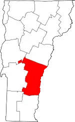 Map of Vermont highlighting Windsor County | |
| Villages | ||
| CDPs | ||
| Other communities | ||
| ||
| Authority control |
|---|