Burnsville Township, Anson County, North Carolina
Burnsville Township, population 1,942, is one of eight townships in Anson County, North Carolina. Burnsville Township is 48.93 square miles (126.7 km2)[1] in size and is located in northwestern Anson County. This township does not have any cities or towns within it.
Burnsville Township, Anson County, North Carolina | |
|---|---|
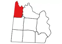 Location of Burnsville Township in Anson County | |
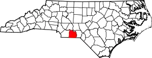 Location of Anson County in North Carolina | |
| Country | United States |
| State | North Carolina |
| County | Anson |
| Area | |
| • Total | 48.93 sq mi (126.72 km2) |
| Highest elevation [2] (high point at center of township) | 618 ft (188 m) |
| Lowest elevation [2] (Lanes Creek at the northeastern end of the township) | 214 ft (65 m) |
| Population (2010) | |
| • Total | 1,942[3] |
| • Density | 39.69/sq mi (15.32/km2) |
| Time zone | UTC-4 (EST) |
| • Summer (DST) | UTC-5 (EDT) |
| Area code(s) | 704 |
Geography
Burnsville Township is bounded by the Rocky River on the north and Lanes Creek on the east. Two tributaries to the Rocky River are in Burnsville Township and include Cribs Creek and Richardson Creek.[4]
References
- "NC OneMap". www.nconemap.gov. State of North Carolina. Retrieved 14 October 2020.
- "The National Map - Service Endpoints". viewer.nationalmap.gov. US Geological Survey. Retrieved 16 October 2020.
- "US Census Bureau Populations". data.census.gov. US Census Bureau. Retrieved 16 October 2020.
- "North Carolina Flood Hazard Area Effective". www.nconemap.gov. State of North Carolina. Retrieved 16 October 2020.
Municipalities and communities of Anson County, North Carolina, United States | ||
|---|---|---|
| Towns | 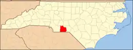 | |
| Unincorporated community | ||
| Ghost town | ||
| ||
This article is issued from Wikipedia. The text is licensed under Creative Commons - Attribution - Sharealike. Additional terms may apply for the media files.