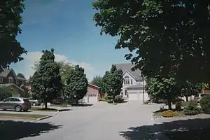
Buttonville, Ontario
Buttonville is a suburban planned neighbourhood from a former Police village in the city of Markham, Ontario, Canada, west of the larger Unionville neighbourhood. It is a former hamlet and Police village, named after its founder, John Button. About 30,000 residents live in the area. It is located along the Woodbine Avenue corridor from approximately Highway 7 in the south to Sixteenth Avenue in the north. The Rouge River is in the northeast and Buttonville Airport and Highway 404 are in the west, with three interchanges. The residential area is located in the eastern, northeastern and the northern section while the industrial area is situated to the west and south down to Highway 7. The area is home to many technology companies near the airport (which incidentally is the location of where weather reports are taken for the Weather Network). There is talk about renaming the community, the John Button Community after its founder since there has been confusion between Unionville and Buttonville, which is popularly considered to be part of Unionville.
Buttonville | |
|---|---|
Planned neighbourhood | |
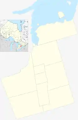 Location within York | |
| Coordinates: 43°51′52″N 79°21′45″W | |
| Country | Canada |
| Province | Ontario |
| Regional Municipality | York |
| City | Markham |
| Government | |
| • Founder | William Berczy |
| Elevation | 636 ft (194 m) |
| Time zone | UTC-5 (Eastern Standard Time (EST)) |
| • Summer (DST) | UTC-4 (Eastern Daylight Time (EDT)) |
| Forward sortation area | L3R |
| Area code(s) | 905 and 289 |
| NTS Map | 030M14 |
| GNBC Code | FANMF |
History
The area was first settled by William Berczy who got an original crown grant of land. The police village in Markham Township was named after John Button (b. 1772) who bought property here in 1808. By 1860, John Button's descendants owned a number of lots in what is today Buttonville. By 1878 the village had a post office, a grist mill, a wagon maker, a school, a Lutheran church and a Methodist church.[1] Buttonville Community Hall was relocated from L'Amoureaux in Scarborough from what was a Methodist chapel c. 1840s and closed in 1938.
Unionville housing developments did not began until the 1960s near Cachet Woods at Woodbine Ave. and Major Mackenzie Drive, and the industrial area began to appear further south. In the 1980s housing developments came to the western part of Markham along with the industries which later flowed with technological and financial companies including Allstate. Buttonville was first accessed when Highway 404 opened several interchanges in the 1970s. Between 1994 and 1996, more houses continued northeast of Buttonville and a few years later, north of the airport and more housing continued until 2004.
Geography
- Population:
- 1990: about 10,000
- 2002: about 30,000
Farmlands formerly surrounded Buttonville and forests were around Buttonville especially to its south. Between 1980 and 2000, the farmlands were developed.
Transportation
- Toronto/Buttonville Municipal Airport is located at 16th Avenue and Highway 404
Public transit in Buttonville is served by:
- York Region Transit/Viva routes Viva Purple, 1 Highway 7 (both serving Highway 7), 85 Rutherford-16th (Sixteenth), and 24 Woodbine (Woodbine) operates regular bus service.
The neighbourhood is served by one major highways and several arterial roads:
- Highway 404 runs north–south on the west side of and connected to east-south streets
- Highway 7 runs east–west on the south side.
- Sixteenth Avenue runs east–west on the north side.
- Woodbine Avenue runs north–south through its centre. The historic settlement is located along it south of Sixteenth Avenue.
Nearest communities
- Richmond Hill, west
- Unionville, east
- Milliken, south
- Stouffville, north
Education
- Buttonville PS
- YRDSB Museum and Archives housed in 1850 Buttonville Schoolhouse
References
- For a fuller history, cf. Isabel Champion, ed., Markham: 1793-1900 (Markham, ON: Markham Historical Society, 1979), pp. 228-231; 138; 158. See also the detailed 1878 map, "Township of Markham," Illustrated historical atlas of the county of York and the township of West Gwillimbury & town of Bradford in the county of Simcoe, Ont. (Toronto: Miles & Co., 1878).
Largest city: Toronto | ||
| Regions |  | |
| Cities | ||
| Towns | ||
| Townships | ||
| Municipalities | ||