Buxa Fort
Buxa Fort is located at an altitude of 867 metres (2,844 ft) in the Buxa Tiger Reserve, in the Kalchini CD block in the Alipurduar subdivision of the Alipurduar district, in West Bengal, India. It is located 30 kilometres (19 mi) from Alipurduar, the nearest town. The Bhutan King used the fort to protect the portion of famous Silk Route connecting Tibet with India, via Bhutan. Still later during the unrest in the occupation of Tibet, hundreds of refugees arrived at the place and used the then abandoned fort as a place of refuge.
| Buxa Fort | |
|---|---|
| Alipurduar district, West Bengal | |
 Buxa Fort | |
 Buxa Fort  Buxa Fort | |
| Coordinates | 26°45′17.86″N 89°34′49.04″E |
| Type | Hill Fort / Prison |
| Height | 867 metres (2,844 ft) |
| Site information | |
| Controlled by | (formerly) British Raj |
| Open to the public | Yes |
| Condition | Ruins |
| Site history | |
| Built by | British Empire |
| In use | Abandoned in 1951 |
| Materials | Bamboo (original), Stone |
| Battles/wars | Bhutan War |
History
Its origin is uncertain. Before the occupation of the fort by the British, it was a point of contention between the King of Bhutan and the Cooch Kings.
British occupation
The British on invitation of the Cooch King intervened and captured the fort which was formally handed over to the British on November 11, 1865 as part of Treaty of Sinchula.[1] The British reconstructed the fort from its bamboo wood structure to stone structure. The fort was to later be used as a high security prison and detention camp in the 1930s;[2] it was the most notorious and unreachable prison in India after the Cellular Jail in Andaman. Nationalist revolutionaries belonging to the Anushilan Samiti and Yugantar group such as Krishnapada Chakraborty were imprisoned there in the 1930s. Forward Bloc leader and ex-Law Minister of West Bengal, Amar Prasad Chakraborty, was also imprisoned at Buxa Fort in 1943. Besides, some communist revolutionaries and intellectuals like the poet Subhash Mukhopadhyay were imprisoned here in the 1950s.
Tibetan refugee crisis
Drepung was one of the most celebrated monasteries in Tibet, and with over 10,000 monks before the Chinese invasion. But in March 1959, Chinese troops tasked with quelling the Tibetan uprising moved aggressively against the monastery; Only a few hundred monks escaped to India. These expatriate monks, representing all the diverse Tibetan orders, first set up a monastic study center and refugee camp in Buxa Fort, on the grounds of the jungle-bound former prison camp.[3]
In 1966, the Indian Ministry of External Affairs was alerted to the conditions of the Buxa refugee camps, and it became apparent that the Tibetan refugees would have to be relocated to a more hospitable place. Initially reluctant, a message from the Dalai Lama, urging them to think of the future and to strive for sufficiency, and the option of settling near other Tibetan refugees convinced the monks to move, and in 1971 the monks moved to their new locations at Bylakuppe and Mundgod in the state of Karnataka.[4]
Geography
| Places and tea estates in the eastern portion of Alipurdar subdivision (including Kalchini, Kumargram and Alipuduar II CD blocks) in Alipurduar district CT: census town, R: rural/ urban centre, N: neighbourhood, A: Air Force Station, NP: national park/ wildlife sanctuary, TE: tea estate, H: historical site Abbreviations used in names – TG for Tea Garden (town/village), TE for Tea Estate Owing to space constraints in the small map, the actual locations in a larger map may vary slightly |
Location
Buxa Fort is located at 26°45′17.86″N 89°34′49.04″E.
Area overview
Alipurduar district is covered by two maps. It is an extensive area in the eastern end of the Dooars in West Bengal. It is undulating country, largely forested, with numerous rivers flowing down from the outer ranges of the Himalayas in Bhutan. It is a predominantly rural area with 79.38% of the population living in the rural areas. The district has 1 municipal town and 20 census towns and that means that 20.62% of the population lives in the urban areas. The scheduled castes and scheduled tribes, taken together, form more than half the population in all the six community development blocks in the district. There is a high concentration of tribal people (scheduled tribes) in the three northern blocks of the district.[5][6][7]
Note: The map alongside presents some of the notable locations in the subdivision. All places marked in the map are linked in the larger full screen map.
Trekking
The following routes are popular among tourists and nature lovers –
- Santalabari to Buxa Fort 5 kilometres (3.1 mi)
- Buxa Fort to Rovers point 3 kilometres (1.9 mi)
- Santalabari to Roopang valley 14 kilometres (8.7 mi)
- Buxa Fort to Lepchakha 5 kilometres (3.1 mi)
- Buxa Fort to Chunabhati 4 kilometres (2.5 mi)
Buxa Fort picture gallery
 Buxa Fort
 Buxa Fort
 Buxa Fort Memorial
 View of Buxa Fort used as Bengal Native Infantry Barrack and later as prison camp by the British Government. India used it as camp for Tibetan refugees.
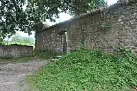 Inside Buxa Fort
 Buxa Fort stone tablet
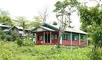 Grace Assembly of God Church Santalabari
References
- Singh, Nagendra (1978). "Appendix VII – The Treaty of Sinchula". Bhutan: a Kingdom in the Himalayas : a study of the land, its people, and their government (2 ed.). Thomson Press Publication Division. p. 243. Retrieved 2011-08-25.
- "West Bengal Forest Development Corporation". Archived from the original on 22 April 2012. Retrieved 9 May 2012.
- "About The Re-establishment of Drepung Gomang Monastic University in India". Drepung Gomang Monastery. Retrieved 2014-04-29.
- "Buxa Refugee Camp" (PDF). Retrieved 9 May 2012.
- "District Statistical Handbook 2014 Jalpaiguri". Tables 2.2, 2.4b. Department of Planning and Statistics, Government of West Bengal. Retrieved 29 June 2020.
- "CD block Wise Primary Census Abstract Data(PCA)". 2011 census: West Bengal – District-wise CD blocks. Registrar General and Census Commissioner, India. Retrieved 29 June 2020.
- "District Census Handbook, Jalpaiguri, Series 20, Part XIIA" (PDF). Census of India 2011, page 13 Physiography. Directorate of Census Operations, West Bengal. Retrieved 18 June 2020.
| Wikimedia Commons has media related to Buxa Fort. |