Alipurduar district
Alipurduar District is the 20th district in the state of West Bengal, India.[1] It consists of Alipurduar municipality, Falakata municipality and six community development blocks: Madarihat–Birpara, Alipurduar–I, Alipurduar–II, Falakata, Kalchini and Kumargram. The six blocks contain 66 gram panchayats and nine census towns. The district has its headquarters at Alipurduar. It was made a district on 25 June 2014.[2]
Alipurduar district | |
|---|---|
District of West Bengal | |
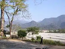
 Jayanti Hills at Alipurduar | |
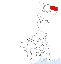 Location of Alipurduar district in West Bengal | |
| Country | |
| State | |
| Division | Jalpaiguri |
| Headquarters | Alipurduar |
| Government | |
| • Lok Sabha constituencies | Alipurduar |
| Area | |
| • Total | 3,136 km2 (1,211 sq mi) |
| Population | |
| • Total | 1,501,983 |
| • Density | 480/km2 (1,200/sq mi) |
| Time zone | UTC+05:30 (IST) |
| Website | http://alipurduar.gov.in/ |
Area
Apart from the Alipurduar municipality, the district contains nine census towns and rural areas of 66 gram panchayats under six community development blocks: Madarihat–Birpara, Alipurduar–I, Alipurduar–II, Falakata, Kalchini and Kumargram.[3] Geographically the district lies in between 26.4°N to 26.83°N and 89°E to 89.9°E.
The nine census towns are Paschim Jitpur, Chechakhata, Alipurduar Railway Junction, Bholar Dabri, Sobhaganj, Falakata, Jaygaon and Uttar Latabari and Uttar Kamakhyaguri.[4]
Railway network
Alipurduar railway division has at least 710 km of railway track. It is the largest division of the NFR zone. In Alipurduar district there are two major stations, Alipurduar junction(APDJ) and New Alipurduar(NOQ). There are other stations in the district viz. Falakata Railway Station, Dalgaon Railway Station,Hasimara Railway Station, Rajabhatkhawa, Hamiltongunj etc.
Legislative segments
There are 5 assembly constituency in Alipurduar district :
- Alipurduars (Vidhan Sabha constituency)
- Kumargram (Vidhan Sabha constituency)
- Falakata (Vidhan Sabha constituency)
- Madarihat (Vidhan Sabha constituency)
- Kalchini (Vidhan Sabha constituency)
As per order of the Delimitation Commission in respect of the delimitation of constituencies in the West Bengal, the area under Kumargram block and seven gram panchayats under Alipurduar–II block, viz. Bhatibari, Kohinoor, Parokata, Mahakalguri, Shamuktala, Turturi and Tatpara–I will constitute the Kumargram assembly constituency of West Bengal. The Majherdabri gram panchayat under Alipurduar–II block and the area under Kalchini block will constitute the Kalchini assembly constituency. The Alipurduar municipality, the Alipurduar Railway Junction census town, and the gram panchayats of Chaporer Par–I, Chaporer Par–II and Tatpara–II under Alipurduar–II block and ten gram panchayats of Alipurduar–I block, viz. Banchukamari, Parorpar, Shalkumar–I, Vivekananda–I, Chakowakheti, Patlakhawa, Shalkumar–II, Vivekananda–II, Mathura and Tapsikhata will form the Alipurduars assembly constituency. The other gram panchayat of Alipurduar–I block, viz. Purba Kanthalbari will form the Falakata assembly constituency along with the area under Falakata block. Madarihat block will be part of Madarihat assembly constituency. Kumargram, Kalchini and Madarihat constituencies will be reserved for Scheduled tribes (ST) candidates. Falakata constituency will be reserved for Scheduled castes (SC) candidates. All these five assembly constituencies will be part of Alipurduars (Lok Sabha constituency), which will be reserved for ST candidates.[5]
Visitor attractions

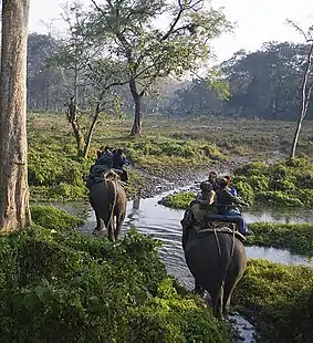
- Buxa Tiger Reserve, IUCN category II national park
- Jayanti Hills
- Buxa Fort, built by British Raj
- Jaldapara National Park
- Chilapata Forests
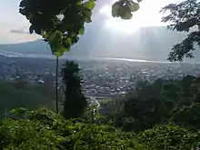
- Jaigaon, a small town of Alipurduar and near the Bhutan border
- Rajabhatkhawa Museum at Rajabhatkhawa
- Rai matang
- Santalabari
- Rovers point
- Roopang valley
- Lepchakhawa
- Chunabhati.
- Tea Gardens
References
- TNN (21 June 2014). "Roy Alipurduar: Alipurduar a new district on June 25". Timesofindia.indiatimes.com. Retrieved 6 April 2020.
- IANS. "Alipurduar becomes Bengal's 20th district | Business Standard News". Business Standard. Retrieved 6 April 2020.
- "Directory of District, Sub division, Panchayat Samiti/ Block and Gram Panchayats in West Bengal, March 2008". West Bengal. National Informatics Centre, India. 19 March 2008. Archived from the original on 25 February 2009. Retrieved 21 December 2008.
- "District Wise List of Statutory Towns (Municipal Corporation, Municipality,Notified Area and Cantonment Board), Census Towns and Outgrowths, West Bengal, 2001". Census of India, Directorate of Census Operations, West Bengal. Archived from the original on 21 July 2011. Retrieved 21 December 2008.
- "Press Note, Delimitation Commission" (PDF). Assembly Constituencies in West Bengal. Delimitation Commission. pp. 4–5, 23. Retrieved 10 January 2009.
External links
| Wikimedia Commons has media related to Alipurduar district. |
Cities, towns and locations in Alipurduar district | |||
|---|---|---|---|
| Cities, municipal and census towns | |||
| Locations other than cities and towns | |||
| Specitic Tea Estates | |||
| Related Topics |
| ||
Places adjacent to Alipurduar district | ||||||||||
|---|---|---|---|---|---|---|---|---|---|---|
| ||||||||||