Bygland
Bygland is a municipality in Agder county, Norway. It is located in the traditional district of Setesdal. The administrative centre of the municipality is the village of Bygland. Other villages in the municipality include Åraksbø, Austad, Byglandsfjord, Grendi, Langeid, Lauvdal, Litveit, Longerak, Moi, Ose, Sandnes, Skåmedal, and Tveit. The Norwegian National Road 9 runs through the municipality, following the river Otra where most of the population of Bygland lives.
Bygland kommune | |
|---|---|
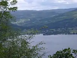 View of Bygland | |
 Agder within Norway | |
 Bygland within Agder | |
| Coordinates: 58°55′27″N 07°45′53″E | |
| Country | Norway |
| County | Agder |
| District | Setesdal |
| Established | 1 Jan 1838 |
| Administrative centre | Bygland |
| Government | |
| • Mayor (2020) | Sigbjørn Åge Fossdal (Ap) |
| Area | |
| • Total | 1,311.75 km2 (506.47 sq mi) |
| • Land | 1,150.35 km2 (444.15 sq mi) |
| • Water | 161.40 km2 (62.32 sq mi) 12.3% |
| Area rank | 76 in Norway |
| Population (2020) | |
| • Total | 1,162 |
| • Rank | 325 in Norway |
| • Density | 1.0/km2 (3/sq mi) |
| • Change (10 years) | −5% |
| Demonym(s) | Byglending[1] |
| Time zone | UTC+01:00 (CET) |
| • Summer (DST) | UTC+02:00 (CEST) |
| ISO 3166 code | NO-4220 |
| Official language form | Nynorsk[2] |
| Website | bygland |
The 1,312-square-kilometre (507 sq mi) municipality is the 76th largest by area out of the 356 municipalities in Norway. Bygland is the 325th most populous municipality in Norway with a population of 1,162. The municipality's population density is 1 inhabitant per square kilometre (2.6/sq mi) and its population has decreased by 5% over the previous 10-year period.[3][4]
General information

The parish of Bygland was established as a municipality on 1 January 1838 (see formannskapsdistrikt law). Since that time, the municipal boundaries have not changed.[5]
Name
The municipality (originally the parish) is named after the old Bygland farm (Old Norse: Byggland), since the first Bygland Church was built there. The first element is bygg which means "barley" and the last element is land which means "land" or "farm".[6]
Coat of arms
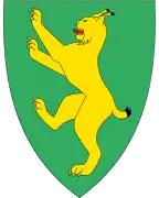
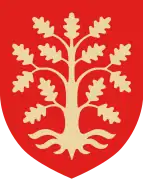
The coat of arms was granted on 15 November 1991. The green arms show a yellow European lynx (Lynx lynx), which symbolises the wild and rich nature in the rural highlands of the municipality. The green background symbolises the agriculture and forests in the municipality.[7][8]
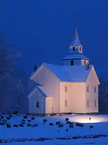
Churches
The Church of Norway has two parishes (sokn) within the municipality of Bygland. It is part of the Otredal prosti (deanery) in the Diocese of Agder og Telemark.
| Parish (sokn) | Church name | Location of the church | Year built |
|---|---|---|---|
| Bygland | Austad Church | Tveit | 1880 |
| Bygland Church | Bygland | 1838 | |
| Sandnes Church | Åraksbø | 1844 | |
| Årdal | Årdal Church | Grendi | 1828 |
Geography
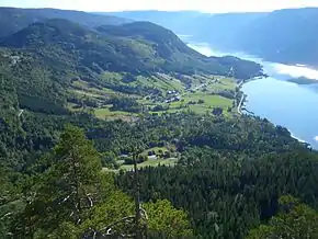
Bygland lies in the middle of the Setesdal valley which is also a traditional district in Aust-Agder county. The valley includes the municipalities of Bykle, Valle, Bygland, Iveland, and Evje og Hornnes. The Otra river flows from the glacially scoured Hardangervidda plateau in the north, through the Setesdal valley (and through Bygland), and into the sea near the city of Kristiansand. The municipality is bordered on the north by Valle, in the east by Fyresdal (Vestfold og Telemark county) and Åmli (Agder county), in the south by Froland and Evje og Hornnes, and in the west by Åseral, Kvinesdal, and Sirdal (all in Agder county).
Bygland is Agder's third largest municipality in area. The majority of the area of the municipality lies in the Setesdalsheiene mountains, at an elevation of over 700 metres (2,300 ft) above sea level. The municipality stretches from the small town Byglandsfjord in the south to the farms at Langeid in the north. Lake Byglandsfjorden is 40 kilometres (25 mi) long and lies on the river Otra. Other lakes include the Åraksfjorden, Gyvatn, Hovatn, Kvifjorden, Longerakvatnet, Straumsfjorden, and Topsæ. The rivers Otra and Topdalsfjorden both run through Bygland on their way south. The Reiårsfossen waterfall is one of many waterfalls in the municipality.
History
.jpg.webp)
.jpg.webp)
The Setesdal Line was a narrow gauge steam railway which went between Vennesla and Byglandsfjord in Bygland. It was built in 1896. The Setesdal Line's operation was terminated in 1962 and the track was removed between Byglandsfjord and Beihølen.
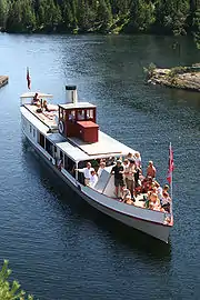
Other transport up the Setesdal valley was provided by the steamships SS Bjoren and Dølen. First placed in operation in 1866, the SS Bjoren is still in operation as a tourist attraction on lake Byglandsfjorden during the summers.
Government
All municipalities in Norway, including Bygland, are responsible for primary education (through 10th grade), outpatient health services, senior citizen services, unemployment and other social services, zoning, economic development, and municipal roads. The municipality is governed by a municipal council of elected representatives, which in turn elect a mayor.[9] The municipality falls under the Kristiansand District Court and the Agder Court of Appeal.
Municipal council
The municipal council (Kommunestyre) of Bygland is made up of 15 representatives that are elected to four year terms. Currently, the party breakdown is as follows:
| Party Name (in Nynorsk) | Number of representatives | |
|---|---|---|
| Labour Party (Arbeidarpartiet) | 3 | |
| Centre Party (Senterpartiet) | 5 | |
| Local List(s) (Lokale lister) | 7 | |
| Total number of members: | 15 | |
Attractions
- Byglandsfjord Station, a former railway station constructed in 1896
- SS Bjoren, a wood-fuelled heritage steamboat that travels the route between Byglandsfjord-Bygland and Bygland-Ose on the lake Byglandsfjorden in the summer.
- Bygland tower, a folk museum.
Notable people
- Even Torkildsen Lande (1758 in Bygland – 1833) a Norwegian farmer and blacksmith, served on the Norwegian Constitutional Assembly
- Oscar Castberg (1846 in Bygland – 1917) a Norwegian painter and sculptor
- Hallvard Sandnes (1893 in Sandnes - 1968) a Norwegian schoolteacher and writer
- Olav Bø (1918 in Bygland – 1998) a Norwegian folklorist
- Kjell Kristian Rike (1944 in Byglandsfjord – 2008) a Norwegian sports commentator
References
- "Navn på steder og personer: Innbyggjarnamn" (in Norwegian). Språkrådet.
- "Forskrift om målvedtak i kommunar og fylkeskommunar" (in Norwegian). Lovdata.no.
- Statistisk sentralbyrå (2020). "Table: 06913: Population 1 January and population changes during the calendar year (M)" (in Norwegian).
- Statistisk sentralbyrå (2020). "09280: Area of land and fresh water (km²) (M)" (in Norwegian).
- Jukvam, Dag (1999). "Historisk oversikt over endringer i kommune- og fylkesinndelingen" (PDF) (in Norwegian). Statistisk sentralbyrå.
- Rygh, Oluf (1905). Norske gaardnavne: Nedenes amt (in Norwegian) (8 ed.). Kristiania, Norge: W. C. Fabritius & sønners bogtrikkeri. p. 204.
- "Civic heraldry of Norway - Norske Kommunevåpen". Heraldry of the World. Retrieved 23 April 2017.
- "Kommunevåpenet" (in Norwegian). Bygland kommune. Retrieved 23 April 2017.
- Hansen, Tore, ed. (12 May 2016). "kommunestyre". Store norske leksikon (in Norwegian). Kunnskapsforlaget. Retrieved 16 November 2020.
- "Table: 04813: Members of the local councils, by party/electoral list at the Municipal Council election (M)" (in Norwegian). Statistics Norway.
External links
| Wikimedia Commons has media related to Bygland. |
| Look up Bygland in Wiktionary, the free dictionary. |
- Municipal fact sheet from Statistics Norway (in Norwegian)
 Aust-Agder travel guide from Wikivoyage
- Culture in Bygland on the map (in Norwegian)
- The Steamboat Bjoren (in Norwegian)
 |
|  | |||||||||||||||||||||
||
| Authority control |
|---|