Cacaulândia
Cacaulândia is a municipality in the Brazilian state of Rondônia. It has an area of 1,961.778 square kilometres (757.447 sq mi). It has a Tropical savanna climate. As of 2019 the estimated population was 6230.
Cacaulândia | |
|---|---|
 Flag  Coat of arms | |
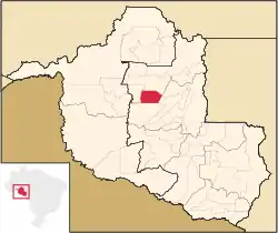 Municipal location within the State of Rondônia | |
 Cacaulândia Location in Brazil | |
| Coordinates: 10.33917°S 62.89528°W | |
| Country | Brazil |
| State | Rondônia |
| Municipality | Cacaulândia |
| Government | |
| • Mayor | Edir Alquieri[1] |
| Area | |
| • Total | 1,961.778 km2 (757.447 sq mi) |
| Elevation | 142 m (466 ft) |
| Population | |
| • Total | 6,269 |
| • Density | 3.2/km2 (8.3/sq mi) |
| Demonym(s) | cacaulandense |
| Time zone | UTC-4 |
| Website | www |
Geography
Cacaulândia is in the state of Rondônia, Brazil.[2] It has an area of 1,961.778 square kilometres (757.447 sq mi) as of 2018.[1] The elevation above sea level is about 142 metres (466 ft).[2]
History
Cacaulândia has its origins in a Northwest Brazil Integrated Development Program (Polonoroeste) project to support farmers in the region through a Núcleo Urbano de Apoio Rural (NUAR: Urban Center of Rural Support). It was named Cacaulândia because it was a large cocoa producing region. 40 hectares (99 acres) of land were donated for the NUAR from lots at the intersection of TB-65 with Line C-15. The region was split off from the municipality of Ariquemes on 13 February 1992, and became a separate municipality and district named Cacaulândia. As of 2007 it remained a municipality with one district.[4]
Climate
The Köppen climate type is Aw : Tropical savanna climate.[5] The average annual temperature is 24 °C (75 °F).[6] The average annual rainfall is 1,890 millimetres (74 in).[7]
Demographics
The population in the 2010 census was 5,736.[8] The estimated population as of 2020 was 6,269.[1] Population density as of 2010 was 2.92 inhabitants per square kilometre (7.6/sq mi).[1] As of 2010, 95.5% of the population had attended school between the ages of 6 and 14. Also as of 2010, the municipal Human Development Index was 0.646. This compares to 0.283 in 1991 and 0.454 in 2000.[1]
On the 2010 census religion was reported as Catholic by 3,071 people, Evangelical by 1,607 people and Animism by 0 people.[8]
In 2017, the average monthly salary of formal workers was 2.1 minimum wages. Formally employed people were 7.6% of the total population. Households with monthly income of up to half a minimum wage per person represent 41.2% of the population.[8] Recent estimates of GDP per capita:[1]
Health and sanitation
21.8% of households have adequate sanitation, 21.9% of urban households are on public roads with afforestation and 1.5% of urban households are on public roads with adequate urbanization (presence of manhole, sidewalk, pavement and curb).[8] Annual hospitalizations due to diarrhea are 0.5 per 1,000 inhabitants.[8] Deaths per 1,000 live births:[1]
Municipal finances
Recent figures for committed municipal expenditure:[1]
Recent figures for realized municipal revenue:[1]
Sources
- Brasil / Rondônia / Cacaulândia, IBGE, retrieved 2020-05-18
- "Cacaulândia", Geonames, retrieved 2020-05-18
- Cacaulândia, Brazilian Institute of Geography and Statistics, retrieved 2020-05-18
- "Cacaulândia, Brazil", Mindat, retrieved 2020-05-18
- História, IBGE, retrieved 2020-05-19
- NASA Earth Observations Data Set Index, NASA, retrieved 30 January 2016
- NASA Earth Observations: Rainfall (1 month - TRMM), NASA/Tropical Rainfall Monitoring Mission, retrieved 30 January 2016
Capital: Porto Velho | ||
| Alvorada d'Oeste | 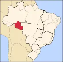 | |
| Ariquemes | ||
| Cacoal | ||
| Colorado do Oeste | ||
| Guajara-Mirim | ||
| Ji-Parana | ||
| Porto Velho | ||
| Vilhena | ||