Cape Prince of Wales
Cape Prince of Wales (Russian: Мыс Принца Уэльского) (65°35′47″N 168°05′05″W) is the westernmost mainland point of the Americas. It was named in 1778 by Captain James Cook of the British Royal Navy,[1] presumably for the Prince of Wales at the time, George Augustus Frederick. Discovered in 1732, by an expedition led by a Russian military geodesist Mikhail Gvozdev in Sviatoi Gavriil (St. Gabriel);[2] later, the cape was named by Vitus Bering for Gvozdev as Mys Gvozdeva (Cape Gvozdev). The Eskimo (Yupik) name of the cape, published by G.Sarychev in 1826,[3] was Nykhta.[4] The current name has been finally approved by the USA Board on Geographic Names Decisions in 1944.[2]
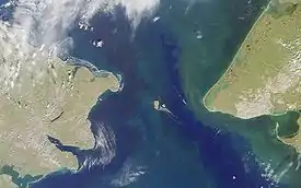
Located on the Seward Peninsula of the U.S. state of Alaska near the settlement of Wales, Cape Prince of Wales is the terminus of the Continental Divide, marking the division between the Pacific and Arctic coasts, as well as marking the limit between the Bering Sea and the Chukchi Sea. It is the eastern boundary of the Bering Strait, 51 miles (82 km) opposite Cape Dezhnev, and adjacent to the Diomede Islands and Fairway Rock.
References
- James Cook (1821). The three voyages of Captain James Cook round the world. VI. Longman, Hurst, Rees, Orme, and Brown. p. 406.
- "Map of the New Discoveries in the Eastern Ocean". World Digital Library. Retrieved December 7, 2020.
- Atlas Svernoy chastii Vostochnogo Okeana... (Atlas of the Northern Part of the Pacific Ocean). Compiled in Sheets by the Imperial Navy Department from Latest Reports and Maps, 1826, under the Direction of Vice-Admiral and Hydrographer Sarychev). St. Petersburg, 1826.
- Orth, Donald J. Dictionary of Alaska Place Names. Washington, DC: GPO, 1967.