Wales, Alaska
Wales (Inupiaq: Kiŋigin, IPA: [kiŋiɣin]; Russian: Уэйлс) is a city[5][6] in the Nome Census Area, Alaska, United States. At the 2010 census the population was 145,[5] down from 152 in 2000. It is the westernmost city within the mainland United States. The westernmost city in Alaska, however, is Adak, located on Adak Island, in the Aleutians West Census Area. Wales Airport serves Wales with flights on Bering Air and Ravn Alaska to Nome.
Wales, Alaska
Kiŋigin | |
|---|---|
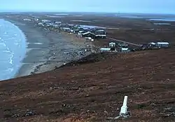 View of the Wales Site, with the city of Wales in the background | |
| Nickname(s): Kingegan | |
 Wales, Alaska Location in Alaska | |
| Coordinates: 65°36′44″N 168°05′21″W | |
| Country | United States |
| State | Alaska |
| Census Area | Nome |
| Incorporated | April 16, 1964[1] |
| Government | |
| • Mayor | Dan Richard, Sr.[2] |
| • State senator | Donald Olson (D) |
| • State rep. | Neal Foster (D) |
| Area | |
| • Total | 2.30 sq mi (5.97 km2) |
| • Land | 2.30 sq mi (5.97 km2) |
| • Water | 0.00 sq mi (0.00 km2) |
| Elevation | 26 ft (8 m) |
| Population (2010) | |
| • Total | 145 |
| • Estimate (2019)[4] | 151 |
| • Density | 65.54/sq mi (25.31/km2) |
| Time zone | UTC-9 (Alaska (AKST)) |
| • Summer (DST) | UTC-8 (AKDT) |
| ZIP code | 99783 |
| Area code | 907 |
| FIPS code | 02-82860 |
| GNIS feature ID | 1404755, 2418870 |
History
A burial mound from the Birnirk culture (A.D. 500 to 900) was discovered near Wales and is now a National Historic Landmark.
In 1827, a Russian Navy report listed the Inupiat villages of "Eidamoo" near the coast and "King-a-ghe" inland in the area.
In 1890, the American Missionary Association established a mission at the site of present-day Wales. In the 1890s, reindeer (domesticated caribou) were brought to the area and in 1894 a reindeer station was established. Wales became an important whaling center due to its location along whale migratory routes, and it was the region's largest and most prosperous village, with more than 500 residents. Wales is named after the country Wales.
The 1918 flu pandemic decimated the population and economy of Wales.
In 2002 a wind-diesel system became operational.
On November 9, 2011, the city experienced the 2011 Bering Sea superstorm. Wind gusts of 89 miles per hour (143 km/h) were recorded in Wales.
Geography
Wales is located at 65°36′44″N 168°5′21″W (65.612116, -168.089285).[7]
Wales is located on the westernmost point of the American mainland, Cape Prince of Wales, on the western tip of the Seward Peninsula. It is at the northern end of the Continental Divide where the Pacific Ocean and Arctic Ocean meet. It is 111 miles (179 km) northwest of Nome.
According to the United States Census Bureau, the city has a total area of 2.8 square miles (7.3 km2), all of it land.
Demographics
| Historical population | |||
|---|---|---|---|
| Census | Pop. | %± | |
| 1880 | 400 | — | |
| 1890 | 488 | 22.0% | |
| 1900 | 396 | −18.9% | |
| 1910 | 337 | −14.9% | |
| 1920 | 136 | −59.6% | |
| 1930 | 170 | 25.0% | |
| 1940 | 193 | 13.5% | |
| 1950 | 141 | −26.9% | |
| 1960 | 128 | −9.2% | |
| 1970 | 131 | 2.3% | |
| 1980 | 133 | 1.5% | |
| 1990 | 161 | 21.1% | |
| 2000 | 152 | −5.6% | |
| 2010 | 145 | −4.6% | |
| 2019 (est.) | 151 | [4] | 4.1% |
| U.S. Decennial Census[8] | |||
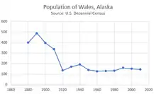
Wales first appeared on the 1880 U.S. Census as the unincorporated Inuit village of "Kingigamute."[9] It was returned in 1890 as "Kingaghee." In 1900 and 1910, it was returned as Cape Prince of Wales (Settlements). In 1920, it was shortened to its present name of Wales. It formally incorporated in 1964.
At the 2000 census there were 152 people in 50 households, including 28 families, in the city. The population density was 53.9 people per square mile (20.8/km²). There were 59 housing units at an average density of 20.9 per square mile (8.1/km²). The racial makeup of the city was 8.55% White, 0.66% Black or African American, 83.55% (127 people) Native American, 0.66% from other races, and 6.58% from two or more races. Hispanic or Latino of any race were 0.66%.[10]
Of the 50 households 38.0% had children under the age of 18 living with them, 38.0% were married couples living together, 8.0% had a female householder with no husband present, and 44.0% were non-families. 40.0% of households were one person and 6.0% were one person aged 65 or older. The average household size was 3.04 and the average family size was 4.43.
The age distribution was 38.2% under the age of 18, 11.8% from 18 to 24, 25.7% from 25 to 44, 21.1% from 45 to 64, and 3.3% 65 or older. The median age was 26 years. For every 100 females, there were 111.1 males. For every 100 females age 18 and over, there were 141.0 males.
The median household income was $33,333 and the median family income was $39,583. Males had a median income of $29,375 versus $22,188 for females. The per capita income for the city was $14,877. About 17.2% of families and 18.3% of the population were below the poverty line, including 26.2% of those under the age of 18 and 50.0% of those 65 or over.
Climate
Wales is located within the polar climate zone (Köppen ET).
| Climate data for Wales, Alaska | |||||||||||||
|---|---|---|---|---|---|---|---|---|---|---|---|---|---|
| Month | Jan | Feb | Mar | Apr | May | Jun | Jul | Aug | Sep | Oct | Nov | Dec | Year |
| Record high °F (°C) | 53 (12) |
49 (9) |
42 (6) |
48 (9) |
57 (14) |
72 (22) |
72 (22) |
73 (23) |
66 (19) |
54 (12) |
67 (19) |
44 (7) |
73 (23) |
| Mean maximum °F (°C) | 33.9 (1.1) |
30.8 (−0.7) |
30.5 (−0.8) |
35.8 (2.1) |
45.1 (7.3) |
56.9 (13.8) |
63.3 (17.4) |
61.2 (16.2) |
53.0 (11.7) |
43.5 (6.4) |
37.2 (2.9) |
32.7 (0.4) |
65.5 (18.6) |
| Average high °F (°C) | 7.2 (−13.8) |
4.3 (−15.4) |
5.4 (−14.8) |
16.0 (−8.9) |
32.2 (0.1) |
43.4 (6.3) |
51.9 (11.1) |
51.0 (10.6) |
44.1 (6.7) |
32.6 (0.3) |
22.0 (−5.6) |
9.9 (−12.3) |
26.7 (−2.9) |
| Daily mean °F (°C) | 3.0 (−16.1) |
−2.5 (−19.2) |
−1.4 (−18.6) |
9.7 (−12.4) |
27.5 (−2.5) |
38.5 (3.6) |
47.4 (8.6) |
47.0 (8.3) |
40.5 (4.7) |
28.6 (−1.9) |
16.5 (−8.6) |
3.8 (−15.7) |
21.5 (−5.8) |
| Average low °F (°C) | −6.7 (−21.5) |
−9.3 (−22.9) |
−8.2 (−22.3) |
3.4 (−15.9) |
22.8 (−5.1) |
33.5 (0.8) |
42.9 (6.1) |
43.0 (6.1) |
36.8 (2.7) |
24.6 (−4.1) |
10.9 (−11.7) |
−2.3 (−19.1) |
16.0 (−8.9) |
| Mean minimum °F (°C) | −26.6 (−32.6) |
−29.5 (−34.2) |
−28.1 (−33.4) |
−15.7 (−26.5) |
5.6 (−14.7) |
25.6 (−3.6) |
34.3 (1.3) |
35.1 (1.7) |
28.7 (−1.8) |
9.3 (−12.6) |
−7.8 (−22.1) |
−21.9 (−29.9) |
−33.8 (−36.6) |
| Record low °F (°C) | −44 (−42) |
−44 (−42) |
−42 (−41) |
−32 (−36) |
−8 (−22) |
20 (−7) |
15 (−9) |
30 (−1) |
−11 (−24) |
−11 (−24) |
−28 (−33) |
−35 (−37) |
−44 (−42) |
| Average precipitation inches (mm) | .41 (10) |
.45 (11) |
.48 (12) |
.27 (6.9) |
.54 (14) |
.73 (19) |
1.47 (37) |
2.46 (62) |
1.99 (51) |
1.41 (36) |
.68 (17) |
.52 (13) |
11.41 (290) |
| Average snowfall inches (cm) | 4.1 (10) |
3.8 (9.7) |
4.5 (11) |
3.3 (8.4) |
2.2 (5.6) |
0.2 (0.51) |
0.2 (0.51) |
0.0 (0.0) |
1.4 (3.6) |
6.2 (16) |
7.7 (20) |
4.6 (12) |
38.2 (97.32) |
| Source 1: NOAA (normals, 1971−2000),[11] Weather.com (extremes) [12] | |||||||||||||
| Source 2: WRCC [13] | |||||||||||||
Education
Wales is served by the Bering Strait School District. Wales School serves grades Pre-K through 12.
References
- "Directory of Borough and City Officials 1974". Alaska Local Government. Juneau: Alaska Department of Community and Regional Affairs. XIII (2): 85. January 1974.
- 2015 Alaska Municipal Officials Directory. Juneau: Alaska Municipal League. 2015. p. 162.
- "2019 U.S. Gazetteer Files". United States Census Bureau. Retrieved June 30, 2020.
- "Population and Housing Unit Estimates". United States Census Bureau. May 24, 2020. Retrieved May 27, 2020.
- "Wales city, Alaska". Profile of General Population and Housing Characteristics: 2010 Demographic Profile Data. United States Census Bureau. Archived from the original on February 12, 2020. Retrieved January 23, 2013.
- "Alaska Taxable 2011: Municipal Taxation - Rates and Policies" (PDF). Division of Community and Regional Affairs, Alaska Department of Commerce, Community and Economic Development. January 2012. Archived from the original (PDF) on 2013-04-25.
- "US Gazetteer files: 2010, 2000, and 1990". United States Census Bureau. 2011-02-12. Retrieved 2011-04-23.
- "Census of Population and Housing". Census.gov. Retrieved June 4, 2015.
- "Geological Survey Professional Paper". U.S. Government Printing Office. 26 August 2018 – via Google Books.
- "U.S. Census website". United States Census Bureau. Retrieved 2008-01-31.
- "Climatology of the United States No. 20 1971−2000: Wales, AK". National Oceanic and Atmospheric Administration. Archived from the original (txt) on 2012-12-14. Retrieved 2012-02-18.
- "Daily Climate Summary for Wales, AK − Temperature and Precipitation". Weather.com. Retrieved 2012-02-18.
- Wales, Alaska - Period of Record : 10/10/1925 to 8/31/1995 Archived 2017-05-25 at the Wayback Machine. Retrieved November 14, 2019.
External links
- Native Village of Wales
- Alaska Division of Community and Regional Affairs: Wales
- Alaska Dispatch: Wales Image Gallery
- Topix: Wales News
Municipalities and communities of Nome Census Area, Alaska, United States | ||
|---|---|---|
| Cities | 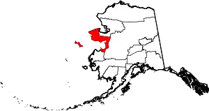 Nome Census Area map | |
| CDP | ||
| Unincorporated communities | ||
| Ghost towns | ||
| ||