Cape Raoul
Cape Raoul is a rural locality and a natural feature in the local government area of Tasman in the South-east region of Tasmania. It is located about 13 kilometres (8.1 mi) south of the town of Nubeena. The 2016 census determined a population of nil for the state suburb of Cape Raoul.[1]
| Cape Raoul Tasmania | |||||||||||||||
|---|---|---|---|---|---|---|---|---|---|---|---|---|---|---|---|
 Cape Raoul | |||||||||||||||
| Coordinates | 43°12′04″S 147°45′48″E | ||||||||||||||
| Population | nil (2016)[1] | ||||||||||||||
| Postcode(s) | 7184 | ||||||||||||||
| Location | 13 km (8 mi) S of Nubeena | ||||||||||||||
| LGA(s) | Tasman | ||||||||||||||
| Region | South-east | ||||||||||||||
| State electorate(s) | Lyons | ||||||||||||||
| Federal Division(s) | Lyons | ||||||||||||||
| |||||||||||||||
Cape Raoul is a confirmed suburb/locality.[2]
Boundaries and location
The shore of the Tasman Sea is the western, southern and eastern boundaries of the locality. The cape is contained within the locality, which is contained within the western section of Tasman National Park.[3]

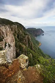
Cape Raoul (the natural feature) is situated at the southernmost part of the Tasman Peninsula, in south eastern Tasmania.[4] It forms the coastline of Raoul Bay, and is part of the dolerite landscape of the Tasman National Park.[5]
Geography
The cape features rock platforms, towering cliffs, columns and off-shore islands.[4] There is a 300-metre-high (980 ft) cliff with scenic views of the coastline.[4] A 7-kilomenter walking track there then descends steadily onto the Cape Raoul plateau, with the spectacular cape of dolerite columns at the end of the plateau.[4]
The cape is accessed via Port Arthur at the end of Stormlea Road.[4]
Columns
The columns at the cape appear to be a colonade formed from columnar jointing. This happens when a pool of magma cools at just the right rate so that as its surface contracts, it cracks into polygonal plates. The cracks accelerate the cooling, extending the cracks vertically, thereby forming columns.[6][7][8]
History
A note from 1911 made a description of the cape:
So named from D'Entrecasteaux's pilot. Flinders called it Basaltic Cape, but only prior to the publication of the maps of the French expedition. "In 1814 Flinders very honestly (writes Comte deFleurieu) replaces on his map the name of Raoull, stating that he gave up the name of Basaltic. This notwithstanding, Scott, Cross, and Arrowsmith chart it as Raoull or Basaltic.
Gallery
 Dolerite columns of Cape Raoul.
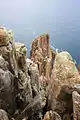 Columns at the tip of the cape.
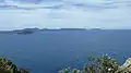 Tasman Island and Tasman Peninsula from Cape Raoul.
References
- "2016 Census Quick Stats Cape Raoul (Tas.)". quickstats.censusdata.abs.gov.au. Australian Bureau of Statistics. 23 October 2017. Retrieved 28 June 2020.
- "Placenames Tasmania – Cape Raoul". Placenames Tasmania. Retrieved 28 June 2020.
Select “Search”, enter 38059Y, click “Search”, select row, map is displayed, click “Details”
- Google (28 June 2020). "Cape Raoul, Tasmania" (Map). Google Maps. Google. Retrieved 28 June 2020.
- Cape Raoul
- https://parks.tas.gov.au/explore-our-parks/tasman-national-park Tasman National Park
- https://www.amusingplanet.com/2017/04/the-dolerite-columns-of-coastal-tasmania.html
- Long, P. E., & Wood, B. J. (1986). Structures, textures, and cooling histories of Columbia River basalt flows. Geological Society of America Bulletin, 97(9), 1144-1155. https://doi.org/10.1130/0016-7606(1986)97<1144:STACHO>2.0.CO;2
- Spry, A. (1962). The origin of columnar jointing, particularly in basalt flows. Journal of the Geological Society of Australia, 8(2), 191-216. https://doi.org/10.1080/14400956208527873
- "TASMANIAN NOMENCLATURE". The Mercury. Hobart, Tasmania. 16 September 1911. p. 10. Retrieved 1 June 2015 – via National Library of Australia. ( TASMANIAN NOMENCLATURE. The Place-Names of the State. A Record Of Origins and Dates. Compiled by "Nomen." – section on Cape Raoul)
South Eastern region of Tasmania, Australia | |||||
|---|---|---|---|---|---|
| Governance former | |||||
| Mountains |
| ||||
| Protected areas, parks and reserves | |||||
| Rivers | |||||
| Harbours, bays, inlets and estuaries | |||||
| Transport | |||||
| Landmarks |
| ||||
| Islands |
| ||||
| Books and newspapers | |||||
| Bioregions | |||||
| |||||