Eaglehawk Neck
The Eaglehawk Neck is a narrow isthmus that connects the Tasman Peninsula with the Forestier Peninsula, and hence to mainland Tasmania, Australia.
| Eaglehawk Neck | |
|---|---|
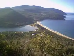 Eaglehawk Neck from Martin Cash's lookout. | |
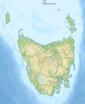 Location in South-eastern Tasmania | |
| Location | Forestier Peninsula and Tasman Peninsula in south-eastern Tasmania, Australia |
| Coordinates | 43°00′36″S 147°55′12″E |
| Length | 400 metres (1,300 ft) |
| Width | 30 metres (98 ft) |
| Designation | |
| LGA | Tasman |
| Website | eaglehawkneck |
The locality of Eaglehawk Neck is in the local government area of Tasman in the South-east region of Tasmania. The locality is about 26 kilometres (16 mi) north-east of the town of Nubeena. At the 2016 census, the settlement of Eaglehawk Neck had a population of 385.[1]
Location and features
Locally known as the Neck, the isthmus itself is around 400 metres (1,300 ft) long and under 30 metres (98 ft) wide at its narrowest point. The area features rugged terrain and several unusual geological formations. These include the Tessellated Pavement, an area of flat rock that looks to be manmade but is in fact formed by erosion. A short walk further via Lufra Cove leads to Clyde Island, accessible for crossings at low tide, which sits at the northern entry to Pirates Bay. The island hosts two grave sites, and a rumbling blow hole cleaves the island.
Eaglehawk Neck offers accommodation at Lufra Hotel and Apartments, near the Tessellated Pavement, and at various b&b's. A nearby footpath leads to Martin Cash's lookout near the top of the hill at the southern end.
Eaglehawk Neck is a well-known local holiday destination. On the eastern side, a beach that stretches around Pirates' Bay is a popular surfing area. In summer the population rises as people return to their holiday homes.
European history
Eaglehawk Neck was gazetted as a locality in 1967.[2]
The Dog Line
As the Eaglehawk Neck forms a natural thin gateway between the peninsulas, it was used by the British as a place to stop convicts attempting to escape from Port Arthur and other penal institutions on the Tasman Peninsula. A system was developed where a line of dogs were chained to posts across the 'Neck' to warn of any convicts attempting to escape.[3] The Dog Line was first implemented in 1831 and was used till the closure of Port Arthur in the 1870s.
Thomas J. Lempriere, a commissary officer at Port Arthur, declared the Eaglehawk Neck as 'impassable'. Despite this, many attempts were made by convicts to escape from the Tasman Peninsula via Eaglehawk Neck, including Martin Cash [4] and William Bannon. The area was heavily patrolled by soldiers, and the guards' quarters still remains as a museum.
The isthmus now provides road access via the Arthur Highway to Port Arthur, part of the Australian Convict Sites, a World Heritage Site that comprises eleven remnant penal sites originally built within the British Empire during the 18th and 19th centuries on fertile Australian coastal strips. Collectively, these sites, including Port Arthur, now represent, "...the best surviving examples of large-scale penal transportation and the colonial expansion of European powers through the presence and labour of convicts."[5]
Post Office
The first Eagle Hawk Neck post office was open from 1875 until 1877. It reopened on 11 January 1895 and closed in 1974.[6]
Geography
The shores of Norfolk Bay and Eaglehawk Bay form the western boundary, while the Tasman Sea forms the eastern.[7]
Road infrastructure
The A9 route (Arthur Highway) enters from the north and runs through to the south-west, where it exits. Route C338 (Blowhole Road / Tasmans Arch Road) starts at an intersection with A9 in the centre and runs south-east until it ends at Tasman Arch.[2][8]
Gallery
 Tessellated Pavement at sunrise.
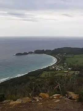 Pirates Bay and Doo Town.
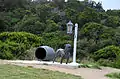 Statue representing the dogline at Eaglehawk Neck
References
- "2016 Census Quick Stats Eaglehawk Neck (Tas.)". quickstats.censusdata.abs.gov.au. Australian Bureau of Statistics. 23 October 2017. Retrieved 4 August 2020.
- "Placenames Tasmania – Eaglehawk Neck". Placenames Tasmania. Retrieved 4 August 2020.
Select “Search”, enter 319T, click “Search”, select row, map is displayed, click “Details”
- "Dog LIne - Discover Tasmania". Discover Tasmania. 2014. Retrieved 6 October 2019.
- Robson, L. L.; Ward, Russel (1966). "Cash, Martin (1808–1877)". Australian Dictionary of Biography. Vol. 1. Melbourne University Press. ISSN 1833-7538. Retrieved 8 August 2015 – via National Centre of Biography, Australian National University.
- "Australian Convict Sites". World Heritage List. UNESCO. 2010. Retrieved 2 August 2010.
- "Post Office List". Premier Postal History. Premier Postal Auctions. Retrieved 16 June 2012.
- Google (4 August 2020). "Eaglehawk Neck, Tasmania" (Map). Google Maps. Google. Retrieved 4 August 2020.
- "Tasmanian Road Route Codes" (PDF). Department of Primary Industries, Parks, Water & Environment. May 2017. Archived from the original (PDF) on 1 August 2017. Retrieved 4 August 2020.
Further reading
- Storey, Shirley; Storey, Peter (1990). Tasman tracks: 25 walks on the Tasman and Forestier Peninsulas. Koonya Press. ISBN 0-6460-1870-1.
External links
- Eaglehawk Neck at walkabout.com.au
- Eaglehawk Neck
South Eastern region of Tasmania, Australia | |||||
|---|---|---|---|---|---|
| Governance former | |||||
| Mountains |
| ||||
| Protected areas, parks and reserves | |||||
| Rivers | |||||
| Harbours, bays, inlets and estuaries | |||||
| Transport | |||||
| Landmarks |
| ||||
| Islands |
| ||||
| Books and newspapers | |||||
| Bioregions | |||||
| |||||