Cardona, Rizal
Cardona, officially the Municipality of Cardona (Tagalog: Bayan ng Cardona), is a 3rd class municipality in the province of Rizal, Philippines. According to the 2015 census, it has a population of 49,034 people. [4]
Cardona | |
|---|---|
| Municipality of Cardona | |
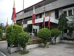 Cardona Municipal Hall | |
 Seal | |
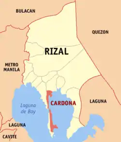 Map of Rizal with Cardona highlighted | |
OpenStreetMap 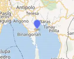
| |
.svg.png.webp) Cardona Location within the Philippines | |
| Coordinates: 14°29′10″N 121°13′44″E | |
| Country | |
| Region | Calabarzon (Region IV-A) |
| Province | Rizal |
| District | 2nd District |
| Founded | February 1, 1914 [1] |
| Barangays | 18 (see Barangays) |
| Government | |
| • Type | Sangguniang Bayan |
| • Mayor | Teodulo C. Campo |
| • Vice Mayor | Gil F. Pandac |
| • Representative | Juan Fidel Felipe F. Nograles |
| • Electorate | 29,006 voters (2019) |
| Area | |
| • Total | 28.56 km2 (11.03 sq mi) |
| Elevation | 29 m (95 ft) |
| Population | |
| • Total | 49,034 |
| • Density | 1,700/km2 (4,400/sq mi) |
| • Households | 11,089 |
| Economy | |
| • Income class | 3rd municipal income class |
| • Poverty incidence | 10.12% (2015)[5] |
| • Revenue | ₱106,976,564.14 (2016) |
| Time zone | UTC+8 (PST) |
| ZIP code | 1950 |
| PSGC | |
| IDD : area code | +63 (0)2 |
| Climate type | tropical monsoon climate |
| Native languages | Tagalog |
| Website | www |
Cardona is part of the 2nd Congressional District of Rizal.
Located about 42 Km east of Manila. With the continuous expansion of Metro Manila, the municipality is now part of Manila's conurbation which reaches Cardona in its easternmost part.
In 1855, Cardona became a town with boundaries set in 1857. Later in June 1901, Cardona formed part of the newly-created Province of Rizal through Act 137 promulgated by the Philippine Commission. In 1903, a succeeding Act annexed the town to the Municipality of Morong. Eleven years then, the Executive Order 108 issued by Governor General Francis Burton Harrison has established the town as an independent municipality.
Etymology
An oral folklore tells how the name “Cardona” was derived from the Spanish word “caldo” referring to a native rice broth. Supposedly, a stranger walking through the street of the town happened to ask the name of the town from a native, who at that time was enjoying a bowl of hot “caldo”. Thinking that the stranger was inquiring as to what he was eating, the native answered “Sapao! Caldo!”
Another story tells that the town of Cardona in Barcelona Province is believed to be the eponym of the town. Settlements in the area during the Spanish-era were on the hills and the place surrounded by waters of the Laguna Lake. Early missionary Franciscan friars have seen its resemblance to the Spanish town which is also located on a hill and is almost surrounded by the waters of the river Cardener. Parts of the present-day Barangays Calahan, Patunhay, Del Remedio, Iglesia, San Roque, Dalig, and Looc are set on these hills.
Barangays
Cardona is politically subdivided into 18 barangays, [3] 11 of which are on the mainland and 7 on Talim Island.
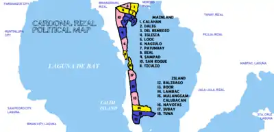
- Mainland
- Calahan
- Dalig
- Del Remedio
- Iglesia
- Looc
- Nagsulo
- Patunhay
- Real (Poblacion)
- Sampad
- San Roque (Poblacion)
- Ticulio
- Talim Island
- Balibago
- Boor
- Lambac
- Malanggam-Calubacan
- Navotas
- Subay
- Tuna
Climate
| Climate data for Cardona, Rizal | |||||||||||||
|---|---|---|---|---|---|---|---|---|---|---|---|---|---|
| Month | Jan | Feb | Mar | Apr | May | Jun | Jul | Aug | Sep | Oct | Nov | Dec | Year |
| Average high °C (°F) | 26 (79) |
27 (81) |
29 (84) |
31 (88) |
31 (88) |
30 (86) |
29 (84) |
29 (84) |
29 (84) |
29 (84) |
28 (82) |
26 (79) |
29 (84) |
| Average low °C (°F) | 22 (72) |
22 (72) |
22 (72) |
23 (73) |
24 (75) |
25 (77) |
24 (75) |
24 (75) |
24 (75) |
24 (75) |
24 (75) |
23 (73) |
23 (74) |
| Average precipitation mm (inches) | 58 (2.3) |
41 (1.6) |
32 (1.3) |
29 (1.1) |
91 (3.6) |
143 (5.6) |
181 (7.1) |
162 (6.4) |
172 (6.8) |
164 (6.5) |
113 (4.4) |
121 (4.8) |
1,307 (51.5) |
| Average rainy days | 13.4 | 9.3 | 9.1 | 9.8 | 19.1 | 22.9 | 26.6 | 24.9 | 25.0 | 21.4 | 16.5 | 16.5 | 214.5 |
| Source: Meteoblue (Use with caution: this is modeled/calculated data, not measured locally.) [6] | |||||||||||||
Demographics
In the 2015 census, the population of Cardona, Rizal, was 49,034 people, [4] with a density of 1,700 inhabitants per square kilometre or 4,400 inhabitants per square mile.
| Year | Pop. | ±% p.a. |
|---|---|---|
| 1903 | 2,580 | — |
| 1918 | 3,278 | +1.61% |
| 1939 | 6,366 | +3.21% |
| 1948 | 8,134 | +2.76% |
| 1960 | 12,476 | +3.63% |
| 1970 | 16,880 | +3.07% |
| 1975 | 21,266 | +4.74% |
| 1980 | 24,503 | +2.87% |
| 1990 | 32,962 | +3.01% |
| 1995 | 35,501 | +1.40% |
| 2000 | 39,003 | +2.04% |
| 2007 | 44,942 | +1.97% |
| 2010 | 47,414 | +1.97% |
| 2015 | 49,034 | +0.64% |
| Source: Philippine Statistics Authority [4] [7] [8][9] | ||
Religion
.JPG.webp)
Christianity is the major religion in the town, and the majority of all Christian denomination is Catholicism and a minority of Iglesia ni Cristo, Born Again, Jehovah's Witnesses and more.
Christian Churches:
- Diocesan Shrine and Parish of Our Lady of the Most Holy Rosary (Catholic Church)
- Our Lady of Lourdes Parish (Catholic Church)
- Cardona Christian Church
- Bethel United Methodist Church
- Dae Heung Presbyterian Church
- Iglesia Ni Cristo
- Kingdom Hall of Jehovah’s Witnesses
Education
State-run Institutions
- University of Rizal System
- Cardona Senior High School
- Bernardo F. San Juan National High School
- Catalino D. Salazar National High School
- Tuna-Balibago National High School
- Mariano C. San Juan Elementary School
- Patunhay-Calahan Elementary School
- Dalig Elementary School
- Looc Elementary School
- Tadlak Elementary School
- Tuna-Balibago Elementary School
- Boor Elementary School
- Barangay DayCare Centers
Private Schools
- Castle for Achievers Learning School
- CJ Learning Center
- Lyceum Internation of the Far East
- Mother Most Chaste School
- MV Montessori School
- Queen Mary Help of Christians Educational Center
- San Francisco Parish School
- Talim Island Academy Foundation
Health Institutions
Public Health Setvices
- Rural Health Unit (RHU) - Health Services are offered at the Municipal Facility, and Health Services Centers in individual Barangays. Cardona RHU is headed by Dra. Eloida Silao.
Private Hospitals
- Queen Mary Help of Christians Hospital (Calahan)
- Carlos Medical and Maternity Hospital (Looc)
Transport and Communication
Mode of Transport & Routes
Jeepneys
- Morong - Crossing via Cardona, Double Hi-Way, Floodway
- Morong - Sta.Lucia via Cardona, Triple Hi-Way
- Northbound: to Morong, Baras, or Tanay
- Westbound: to Binangonan, Angono, Taytay, Junction/Robinson’s (Cainta), Sta. Lucia (Cainta), or Crossing (Mandaluyong)
UV Express
- Cardona - Starmall Crossing (Mandaluyong) via Floodway
Ferries
- Mainland (Looc) - Island Barangays
- Cardona (Patunhay) - Makati (Guadalupe) not yet in service
Telecommunication
Landlines
- PLDT
- Globe
Cell sites
- Globe
- Smart
- Sun
Cable Internet
- Cheetah Broadband
- PLDT DSL
References
- http://cardonarizal.gov.ph/government/history/
- Municipality of Cardona | (DILG)
- "Province: Rizal". PSGC Interactive. Quezon City, Philippines: Philippine Statistics Authority. Retrieved 12 November 2016.
- Census of Population (2015). "Region IV-A (Calabarzon)". Total Population by Province, City, Municipality and Barangay. PSA. Retrieved 20 June 2016.
- "PSA releases the 2015 Municipal and City Level Poverty Estimates". Quezon City, Philippines. Retrieved 1 January 2020.
- "Cardona: Average Temperatures and Rainfall". Meteoblue. Retrieved 11 May 2020.
- Census of Population and Housing (2010). "Region IV-A (Calabarzon)". Total Population by Province, City, Municipality and Barangay. NSO. Retrieved 29 June 2016.
- Censuses of Population (1903–2007). "Region IV-A (Calabarzon)". Table 1. Population Enumerated in Various Censuses by Province/Highly Urbanized City: 1903 to 2007. NSO.
- "Province of Rizal". Municipality Population Data. Local Water Utilities Administration Research Division. Retrieved 17 December 2016.
External links
| Wikimedia Commons has media related to Cardona, Rizal. |
- Official website
- Cardona Profile at PhilAtlas.com
- Philippine Standard Geographic Code
- Philippine Census Information
- Local Governance Performance Management System
Places adjacent to Cardona, Rizal | ||||||||||
|---|---|---|---|---|---|---|---|---|---|---|
| ||||||||||