Carmel River (California)
The Carmel River is a 36 mi (58 km) river on the Central Coast of California in Monterey County that originates in the Ventana Wilderness Area of the Santa Lucia Mountains.[3] The river flows northwest through the Carmel Valley with its mouth at the Pacific Ocean south of Carmel-by-the-Sea, at Carmel Bay. It is often considered the northern boundary of Big Sur. The Carmel River drains a watershed of about 255 square miles (660 km²).
| Carmel River | |
|---|---|
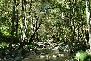 Carmel River in the Ventana Wilderness | |
 Location of the mouth of the Carmel River in California | |
| Location | |
| Country | United States |
| Physical characteristics | |
| Source | |
| • location | Santa Lucia Mountains |
| • coordinates | 36.318018°N 121.645501°W |
| Mouth | |
• location | Pacific Ocean |
• coordinates | 36.536072°N 121.928010°W |
• elevation | Sea level |
| Length | 36 mi (58 km) |
| Basin size | 660 km2 (250 sq mi) |
History
The mouth of the Carmel River was first seen by Spanish explorer Sebastián Vizcaíno shortly before he landed in Monterey Bay in December 1602. He wrote about visiting the river on January 3, 1603, but greatly exaggerated its proportions, confusing later explorers.[1]
Later that winter the local springs near Monterey froze, and the explorers had to cross the peninsula to find freshwater. Fathers Junípero Serra and Juan Crespí moved Mission San Carlos Borromeo de Carmelo from Monterey to its present site by the Carmel River in 1771,[1] they directed Indian laborers to dig ditches from the Carmel River to water their crops. The river has supplied ranchers and residents ever since.[4]
After railroad baron Charles Crocker built the Hotel Del Monte, he commissioned construction of the so-called Chinese Dam in 1883 on the upper river near present-day Cachagua. It supplied 400 acre-feet of water annually to the hotel.[4]
In his 1945 novel Cannery Row John Steinbeck wrote "The Carmel is a lovely little river. It isn't very long but in its course it has everything a river should have."[5]
Etymology
Vizcaino named it Rio del Carmelo, likely because his voyage was accompanied by three Carmelite friars.[1]
Ecology
The river flows through various habitats beyond its bankside riparian zone: starting in mixed evergreen forests, then down through montane chaparral and woodlands to remnant coastal sage and chaparral and coastal prairie, concluding through minor coastal sand dunes at its Pacific mouth.
Stream restoration and conservation projects are proceeding to return/enhance migrating fish in the family Salmonidae, such as the steelhead trout, and other aquatic and terrestrial flora and fauna to the Carmel River ecosystem.
Dams and reservoirs
The Carmel River had three dams, with their reservoirs used for drinking water and having severe sediment buildup.
The San Clemente Dam, built in 1921, was located 18.5 miles (29.8 km) upstream from the ocean, and once provided drinking water throughout the Monterey Peninsula. It was the second of three dams built on the Carmel River, preceded by the Old Carmel River Dam built in the 1880s and followed by the Los Padres Dam in 1949.[6] The San Clemente Dam had an original capacity of 1,450 acre⋅ft (1,790,000 m3), but as of 2002, the capacity had fallen to less than 150 acre feet (190,000 m3) because it was 90 percent silted up.
State regulators declared in 1991 that it was in danger of collapsing in an earthquake and spilling the 40 million US gallons (150,000 m3) of water trapped behind its crumbling walls. In January 2010 an agreement was reached with the California American Water Company to dig a new half-mile channel to bypass and strand the sediment behind the dam at a cost of $84 million, beginning in 2013.[7] The Carmel River Reroute and San Clemente Dam Removal Project (CRRDR) was completed at the end of 2015, opening up 6.5 miles (10.5 km) of historic steelhead rainbow trout habitat on the river mainstem, plus access to three named tributary creeks: San Clemente Creek,[8] Pine Creek[9] and Cachagua Creek.[10]
The Los Padres Dam, built in 1949, is located 25 miles (40 km) upstream from the ocean. Its original capacity was 3,030 acre feet (3,740,000 m3), but as of 2008, its capacity was only 1,775 acre feet (2,189,000 m3).
The oldest dam on the river, which was used as a turnout for a water pipeline, was located approximately 2,000 feet (610 m) downstream of San Clemente Dam. It was removed as part of the San Clemente Dam Removal Project.[11] This first dam and associated pipeline was constructed ca. 1880 by Charles Crocker and the Pacific Improvement Company with a labor force that included approximately 700 Chinese workers. This small dam, which has been referred to as the "Chinese Dam" and "Old Carmel River Dam," was built using hewn and mortared granite blocks. A cast-iron pipe 25 miles (40 km) long and 12 inches (30 cm) in diameter was used to deliver water from the dam to the first Del Monte Hotel on the Monterey Peninsula, crossing the Carmel River five times on its way. Remnants of the original iron pipe still exist along Carmel Valley Road, but no records have been found to show where the pipe crossed the river.
See also
References
- Erwin G. Gudde; William Bright (1949). California Place Names: The Origin and Etymology of Current Geographical Names. Berkeley, California: University of California Press. p. 54. ISBN 978-0-520-24217-3.
- Bancroft, Hubert H. (1884). History of California, 7 volumes. 1. San Francisco, California: A.L. Bancroft and Company. p. 170, note 7.
- "Carmel River". Geographic Names Information System. United States Geological Survey.
- Schmalz, David Just as the Carmel River is bouncing back, its most iconic species—steelhead trout—are under attack September 21, 2017 Monterey County Weekly
- "Quote from John Steinbeck". Good Reads. Retrieved October 7, 2015.
- Jessica Neafsey (January–February 2016). "Undamming the Carmel: Restoring an Endangered River". Land and Water. 60 (1). Retrieved February 14, 2016.
- Peter Fimrite (January 14, 2010). "Deal reached to bypass San Clemente dam". San Francisco Chronicle. Retrieved April 19, 2010.
- "San Clemente Creek". Geographic Names Information System. United States Geological Survey.
- "Pine Creek". Geographic Names Information System. United States Geological Survey.
- "Cachagua Creek". Geographic Names Information System. United States Geological Survey.
- Rogers, Paul (2019-05-08). "Four years after California's largest dam removal project, how are the fish doing?". The Mercury News. Retrieved 2019-05-09.
Further reading
- March, Ray A. (2012-04-01). River in Ruin: The Story of the Carmel River. University of Nebraska Press. ISBN 0803240457.
- California Department of Boating and Waterways
- California Coastal Conservancy: Carmel River
External links
- Carmel River Watershed Conservancy website
- Carmel River Basin Relief Map
- Carmel River Steelhead Association: Carmel River photograph gallery
- Video "New Life for the Carmel River" June 2013 California American Water
- San Clemente Dam Removal & Carmel River Reroute Project
- http://www.carmelsteelhead.org/