California coastal sage and chaparral
The California coastal sage and chaparral (Spanish: Salvia y chaparral costero de California) is a Mediterranean forests, woodlands, and scrub ecoregion located in southwestern California (United States) and northwestern Baja California (Mexico). It is part of the larger California chaparral and woodlands ecoregion.
| California coastal sage and chaparral | |
|---|---|
 Coastal sage and chaparral of Crystal Cove State Park | |
 | |
| Ecology | |
| Realm | Nearctic |
| Biome | Mediterranean forests, woodlands, and scrub |
| Borders | Baja California Desert, California montane chaparral and woodlands, Sierra Juárez and San Pedro Mártir pine–oak forests and Sonoran Desert |
| Bird species | 291[1] |
| Mammal species | 74[1] |
| Geography | |
| Area | 64,491 km2 (24,900 sq mi) |
| Countries | Mexico and United States |
| States | Baja California and California |
| Rivers | Los Angeles River, San Gabriel River, Santa Ana River, Santa Clara River, Tijuana River |
| Conservation | |
| Conservation status | Vulnerable[2] |
| Global 200 | Yes |
| Habitat loss | 18.5%[1] |
| Protected | 17.8%[1] |
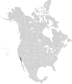
Location
California coastal sage and chaparral is part of the Mediterranean forests, woodlands, and scrub biome. It covers about 14,000 square miles (36,000 km2) of coastal terraces, plains, and foothills south to the Punta Baja in northern Baja California, including the southern slopes of the Santa Monica Mountains, Santa Ana Mountains, and Santa Rosa Mountains, the San Joaquin Hills, the Channel Islands, Guadalupe Island, and Cedros Island.
Climate
The climate is Mediterranean, with cool, wet winters and hot, dry summers with fog.[3]
Flora
The plant species of the California coastal sage and chaparral ecoregion are diverse, with high endemism. The main plant communities are coastal sage scrub, California coastal prairie, chaparral, southern oak woodland, pine forests, riparian woodland, and wetlands.[4]
Coast
Prominent coast adjacent species include: California sagebrush (Artemisia californica) and brittlebush (Encelia californica), along with California buckwheat (Eriogonum fasciculatum) and Munz's sage (Salvia munzii).
At the southern areas of this coastal ecoregion, cacti and succulents can be found, such as: Shaw's agave (Agave shawii), coastal dudleya (Dudleya caespitosa), coastal cholla (Cylindropuntia prolifera), golden cereus (Bergerocactus emoryi), and other prickly pear (Opuntia), Yucca and Dudleya species.
Some of the endemic plants to the ecoregion's southern coast zone include: San Diego thornmint (Acanthomintha ilicifolia), San Diego ambrosia (Ambrosia pumila) and San Diego barrel cactus (Ferocactus viridescens).
Slopes

Higher up from the shoreline the slopes are densely covered in chaparral shrubs, such as: chamise (Adenostoma fasciculatum), and many California lilac (Ceanothus) and manzanita (Arctostaphylos) species. Chaparral yucca (Hesperoyucca whipplei) is commonplace throughout the climate zone.
Trees
Still higher are mountain conifers such as the huge sugar pine (Pinus lambertiana), ponderosa pine (Pinus ponderosa), Jeffrey pine (Pinus jeffreyi), Coulter pine (Pinus coulteri), and incense cedar (Calocedrus decurrens). Endemic cypress (Cupressus) species include: the Monterey cypress (Cupressus macrocarpa), Gowen cypress (Cupressus goveniana), and Sargent's cypress (Cupressus sargentii).
Another endemic tree is the rare Torrey pine (Pinus torreyana), which is only native to the coastal bluffs in Torrey Pines State Reserve near San Diego, and off the coast on Santa Rosa Island.
Riparian canyon bottoms can have California sycamores (Platanus racemosa). California oak woodlands are at many elevations in less xeric locations, with species such as the coast live oak (Quercus agrifolia). Valley oaks (Quercus lobata) once covered the adjacent sheltered plains, such in the Los Angeles basin and San Fernando Valley.
Southern California black walnut (Juglans californica) remnant populations are on some north faces of the Santa Monica Mountains, Santa Susana Mountains, and the San Jose Hills.
Channel Islands
The Channel Islands are mostly covered in coastal sage and chamise chaparral with some oak woodland including endemic and/or rare: buckwheats (Eriogonum spp.), oaks (such as island oak—Quercus tomentella), and Dudleya species restricted to these islands.
Other habitats
In and around these different habitats this diverse ecoregion also contains 'patches' of stream-riverside riparian zone oak-sycamore woodlands, native and introduced species grasslands, and serpentine barrens. Seasonal wetland habitats include intermittent creeks, ponds, vernal pools, and floodplains.
Wildfires are part of the natural fire ecology throughout the ecoregion. Habitats of this hot, dry coast must survive and revive following the regular forest fires, and the dominant plant species have adapted to do that.
Fauna
Wildlife found here includes the Hermes copper and Quino checkerspot butterflies among the 200 butterfly species found here. Other animals include the rosy boa, red-diamond rattlesnake (Crotalus ruber), the San Diego subspecies of the coast horned lizard and the western banded gecko (Coleonyx variegatus), San Diego pocket mouse, Stephens' kangaroo rat (Dipodomys stephensi), and Merriam's kangaroo rat, western patch-nosed snake (Salvadora hexalepis), and cheese-weed moth lacewing (Chrysoperla species). Vernal pools in the ecoregion are home to Riverside fairy shrimp (Streptocephalus woottoni).
The California gnatcatcher is a small bird, endemic to this coastal ecoregion, which has been protected as its habitat is now designated an Important Bird Area. Other birds found here are the endemic Nutall's woodpecker (Picoides nuttallii) of the oak woodland, and the coastal populations of the protected cactus wren (Campylorhynchus brunneicapillus).
Important Bird Areas in Mexico include Isla Guadalupe and Isla Cedros, and parts of Sierra de Juárez and Sierra de San Pedro Mártir.
Threats and preservation
This attractive coastline is highly vulnerable to urban, recreational, and agricultural development and only 15% of original habitat is intact.[5] Habitats are vulnerable to livestock grazing, which has removed much native vegetation on the Channel Islands, such as Santa Cruz where sheep were grazed for over 100 years. Another threat ironically is fire control, which only allows the amount of dry material in the forest to build up, resulting eventually in massive fires. However, in many chaparral regions such as the Santa Monica Mountains, increased fire frequency is the larger concern because fire return intervals in mature chaparral communities should be 30–150 years, unlike much of the region which often has return intervals of 20 years or less.[6][7]
There are patches of coastal sage scrub in Marine Corps Base Camp Pendleton, the Santa Monica Mountains, the San Joaquin Hills near Laguna Beach, and the Irvine Ranch in Orange County, California. Additional patches of coastal sage scrub exist in Southern California in the Angeles National Forest.
Protected areas
A 2017 assessment found that 1,925 km², or 6%, of the ecoregion is in protected areas.[8] Protected areas include Channel Islands National Park, Santa Monica Mountains National Recreation Area, Point Mugu State Park, Malibu Creek State Park, Topanga State Park, Griffith Park, Santa Susana Pass State Historic Park, Ballona Wetlands State Ecological Reserve, Chino Hills State Park, Crystal Cove State Park, the Santa Rosa Plateau Reserve, and Torrey Pines State Reserve.
External links
 Media related to California coastal sage and chaparral at Wikimedia Commons
References
- "The Atlas of Global Conservation". maps.tnc.org. Retrieved 2020-11-16.
- "California interior chaparral and woodlands | Ecoregions | WWF". World Wildlife Fund. Retrieved 2020-11-16.
- "California coastal sage and chaparral". Terrestrial Ecoregions. World Wildlife Fund.
- Schoenherr, Allan A. (1992). A Natural History of California. Berkeley, CA: University of California Press.
- Castellanos, A. V.; Mendoza, S. R. (1991). "Aspectos Socioeconómicos". In Ortega, A.; Arriaga, L. (eds.). La Reserva de la Biosfera "El Vizcaíno" en la Peninsula de Baja California. México (in Spanish). 4. Centro de Investigaciones Biológicas de Baja California Sur. pp. 35–52.
- "Wildfire in the Chaparral". California Chaparral Institute. Retrieved 2016-07-30.
- "Mean Fire Return Interval". Santa Monica Mountains National Recreation Area. National Park Service. Retrieved 2016-07-30.
- Eric Dinerstein, David Olson, et al. (2017). An Ecoregion-Based Approach to Protecting Half the Terrestrial Realm, BioScience, Volume 67, Issue 6, June 2017, Pages 534–545; Supplemental material 2 table S1b.