Castle Rock (Utah)
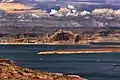
Castle Rock is a 4,321-foot (1,317 meter) elevation sandstone summit located in Glen Canyon National Recreation Area, in Kane County of southern Utah.[2] It is situated 6.5 miles (10.5 km) north of the town of Page, and 2.5 miles (4.0 km) northeast of the Wahweap marina. Castle Rock towers over 600 feet above Lake Powell, and becomes an island when the lake is full. This iconic landmark of the Lake Powell area is composed primarily of Entrada Sandstone.[3] This sandstone, which was originally deposited as sandy mud on a tidal flat, is believed to have formed about 160 million years ago during the Jurassic period as a giant sand sea, the largest in Earth's history.
| Castle Rock | |
|---|---|
.jpg.webp) Southwest aspect | |
| Highest point | |
| Elevation | 4,321 ft (1,317 m) [1] |
| Prominence | 701 ft (214 m) [1] |
| Parent peak | Point 4380[1] |
| Isolation | 1.63 mi (2.62 km) [1] |
| Coordinates | 37°00′56″N 111°27′21″W [2] |
| Geography | |
 Castle Rock Location in Utah  Castle Rock Castle Rock (the United States) | |
| Location | Glen Canyon National Recreation Area Kane County, Utah, U.S. |
| Parent range | Colorado Plateau |
| Topo map | USGS Warm Creek Bay |
| Geology | |
| Age of rock | Jurassic |
| Type of rock | Entrada Sandstone |
Gallery
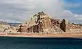 From southwest
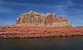 South aspect, from Castle Rock Cut
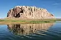 from west
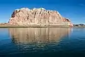

.jpg.webp)
.jpg.webp)
.jpg.webp)
Climate
According to the Köppen climate classification system, Castle Rock is located in an arid climate zone with hot, very dry summers, and chilly winters with very little snow.[4] Spring and fall are the most favorable seasons to visit.
| Climate data for Wahweap, AZ | |||||||||||||
|---|---|---|---|---|---|---|---|---|---|---|---|---|---|
| Month | Jan | Feb | Mar | Apr | May | Jun | Jul | Aug | Sep | Oct | Nov | Dec | Year |
| Record high °F (°C) | 69 (21) |
78 (26) |
85 (29) |
94 (34) |
104 (40) |
110 (43) |
120 (49) |
115 (46) |
105 (41) |
96 (36) |
80 (27) |
70 (21) |
120 (49) |
| Average high °F (°C) | 47.2 (8.4) |
53.8 (12.1) |
63.0 (17.2) |
72.8 (22.7) |
83.8 (28.8) |
94.1 (34.5) |
98.8 (37.1) |
95.7 (35.4) |
87.7 (30.9) |
73.7 (23.2) |
58.3 (14.6) |
47.1 (8.4) |
73.0 (22.8) |
| Average low °F (°C) | 26.9 (−2.8) |
31.8 (−0.1) |
37.8 (3.2) |
44.6 (7.0) |
54.9 (12.7) |
64.1 (17.8) |
71.3 (21.8) |
69.3 (20.7) |
60.7 (15.9) |
48.9 (9.4) |
36.9 (2.7) |
27.4 (−2.6) |
47.9 (8.8) |
| Record low °F (°C) | −2 (−19) |
4 (−16) |
21 (−6) |
16 (−9) |
29 (−2) |
40 (4) |
48 (9) |
51 (11) |
36 (2) |
24 (−4) |
15 (−9) |
3 (−16) |
−2 (−19) |
| Average precipitation inches (mm) | 0.59 (15) |
0.56 (14) |
0.63 (16) |
0.37 (9.4) |
0.36 (9.1) |
0.17 (4.3) |
0.51 (13) |
0.75 (19) |
0.59 (15) |
0.85 (22) |
0.57 (14) |
0.41 (10) |
6.36 (160.8) |
| Average snowfall inches (cm) | 0.2 (0.51) |
0.2 (0.51) |
0 (0) |
0 (0) |
0 (0) |
0 (0) |
0 (0) |
0 (0) |
0 (0) |
0 (0) |
0 (0) |
0.3 (0.76) |
0.7 (1.78) |
| Source: http://www.wrcc.dri.edu/cgi-bin/cliMAIN.pl?az9114 | |||||||||||||
See also
References
- "Castle Rock - 4,321' UT". listsofjohn.com. Retrieved 2020-11-14.
- "Castle Rock". Geographic Names Information System. United States Geological Survey. Retrieved 2020-11-14.
- T.C. Chidsey, Jr., D.A. Sprinkel, G.C. Willis, P.B. Anderson. "Lake Powell Geologic Guide", page 65
- Peel, M. C.; Finlayson, B. L.; McMahon, T. A. (2007). "Updated world map of the Köppen−Geiger climate classification". Hydrol. Earth Syst. Sci. 11. ISSN 1027-5606.
External links
- National Weather Service forecast: Castle Rock