Caué District
Caué is a district of São Tomé and Príncipe, on São Tomé Island. Covering 267 km2 (103 sq mi), it is the largest of the nation's seven districts in terms of area.[1] In population it is the smallest, with 6,031 residents (2012).[2] The district seat is São João dos Angolares. It is divided into the two statistical subdistricts São João dos Angolares and Malanza.[3][2]:15
Caué | |
|---|---|
District | |
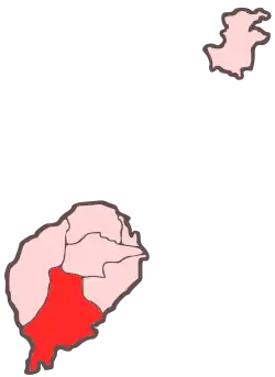 Location within São Tomé and Príncipe | |
| Coordinates: 0°5′N 6°35′E | |
| Country | São Tomé and Príncipe |
| Island | São Tomé |
| Seat | São João dos Angolares |
| Area | |
| • Total | 267 km2 (103 sq mi) |
| Population (2012) | |
| • Total | 6,031 |
| • Density | 23/km2 (59/sq mi) |
| Time zone | UTC+0 (UTC) |
Geography
The district includes the small islet of Rolas where the equator passes right though the islet's only settlement. Other than Ilhéu das Rolas, the district also includes other islets including Ilhéu Quixibá and Sete Pedras. Much of the district lies within Parque Natural Obô de São Tomé.[4] The most notable natural landmark is the volcanic vent Pico Cão Grande.
Population
| Year | Population |
|---|---|
| 1940[5] | 6,653 |
| 1950[5] | 6,917 |
| 1960[5] | 5,848 |
| 1970[5] | 3,837 |
| 1981[5] | 4,607 |
| 1991[5] | 5,322 |
| 2001[5][2] | 5,501 |
| 2012[5][2] | 6,031 |
Settlements
The main settlement is the town São João dos Angolares. Other settlements are:
Politics
Caué currently has five seats in the National Assembly.[6]
References
- Sao Tome and Principe, citypopulation.de
- Projecção a nível distrital 2012 - 2020, Instituto Nacional de Estatística
- Statistical divisions of São Tomé and Príncipe, Instituto Nacional de Estatística
- "Parque Natural d'Obô em São Tomé". Retrieved 19 October 2018.
- Evolução da População Recenseada, 1940 a 2012, Instituto Nacional de Estatística
- Elections in São Tomé and Principe, African Elections Database.
Places adjacent to Caué District | ||||||||||
|---|---|---|---|---|---|---|---|---|---|---|
| ||||||||||
| Settlements | | |
|---|---|---|
| Geographical features | ||
| Culture | ||
