Centre-Est Region
Centre-Est is one of Burkina Faso's 13 administrative regions. The population of Centre-Est was 1,578,075 in 2019.[1] The region's capital is Tenkodogo. Three provinces—Boulgou, Koulpélogo, and Kouritenga, make up the region.
Centre-Est | |
|---|---|
Region | |
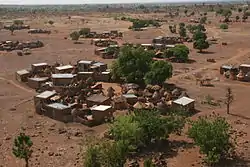 A village in the region | |
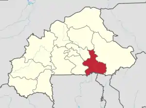 Location in Burkina Faso | |
| Coordinates: 11°30′N 0°15′W | |
| Country | |
| Capital | Tenkodogo |
| Area | |
| • Region | 14,656 km2 (5,659 sq mi) |
| Population (2019 census)[1] | |
| • Region | 1,578,075 |
| • Density | 110/km2 (280/sq mi) |
| • Urban | 292,856 |
| Time zone | UTC+0 (GMT 0) |
| HDI (2017) | 0.418[2] low · 6th |
As of 2019, the population of the region was 1,578,075 with 53.5% females. The population in the region was 7.7% of the total population of the country. The child mortality rate was 39, infant mortality rate was 56 and the mortality of children under five was 93. As of 2007, the literacy rate in the region was 16.6%, compared with a national average of 28.3%.
Geography
Most of Burkino Faso is a wide plateau formed by riverine systems and is called falaise de Banfora. There are three major rivers, the Red Volta, Black Volta and White Volta, which cuts through different valleys. The climate is generally hot, with unreliable rains across different seasons. Gold and quartz are common minerals found across the country, while manganese deposits are also common.[3] The dry season is usually from October to May and rains are common during the wet season from June to September. The soil texture is porous and hence the yield is also poor.[4] The average elevation is around 200 m (660 ft) to 300 m (980 ft) above mean sea level. Among West African countries, Burkino Faso has the largest elephant population and the country is replete with game reserves.[5] The northern regions are generally arid and usually have scrub land and semi-deserts. The principal river is the Red Volta, that originates in the northern region and drains into Ghana. The areas near the rivers usually have flies like tsetse and similium, which are carriers of sleep sickness and river blindness.[3] The average rainfall in the region is around 25 cm (9.8 in) compared with southern regions that receive only 100 cm (39 in) rainfall.[5]
Demographics
| Province | Capital | 2006[6] |
|---|---|---|
| Boulgou Province | Tenkodogo | 542,286 |
| Koulpélogo Province | Ouargaye | 259,395 |
| Kouritenga Province | Koupéla | 330,342 |
As of 2019, the population of the region was 1,578,075 with 53.5% females. The population in the region was 7.7% of the total population of the country. The child mortality rate was 39, infant mortality rate was 56 and the mortality of children under five was 93.[7] As of 2007, among the working population, there were 68.9% employees, 11.9% under employed, 18.2% inactive people, 19.2% not working and 1% unemployed people in the region.[8]
Economy
As of 2007, there were 583.9 km (362.8 mi) of highways, 142.7 km (88.7 mi) of regional roads and 214.2 km (133.1 mi) of county roads. The first set of car traffic was 28, first set of two-wheeler traffic was 2,258 and the total classified road network was 941.[9] The total corn produced during 2015 was 78,512 tonnes, cotton was 43,308 tonnes, cowpea was 45,678 tonnes, ground nut was 42,492 tonnes, millet was 42,342 tonnes, rice was 66,104 tonnes and sorghum was 118,227 tonnes. The coverage of cereal need compared with the total production of the region was 158.00 per cent.[10] As of 2007, the literacy rate in the region was 16.6 per cent, compared with a national average of 28.3 per cent. The gross primary enrolment was 64.8 per cent, pos-primary was 18 per cent and gross secondary school enrolment was 4.4. There were 118 boys and 112 girls enrolled in the primary and post-secondary level. There were 17 teachers in primary & post-secondary level, while there were 500 teachers in post-primary and post-secondary level.[11]
Local administration
Burkina Faso gained independence from France in 1960. It was originally called Upper Volta. There have been military coups until 1983 when Captain Thomas Sankara took control and implemented radical left wing policies. He was ousted by Blaise Compaore, who continued for 27 years until 2014, when a popular uprising ended his rule.[12] As per Law No.40/98/AN in 1998, Burkina Faso adhered to decentralization to provide administrative and financial autonomy to local communities. There are 13 administrative regions, each governed by a Governor. The regions are subdivided into 45 provinces, which are further subdivided into 351 communes. The communes may be urban or rural and are interchangeable. There are other administrative entities like department and village. An urban commune has typically 10,000 people under it. If any commune is not able to get 75 per cent of its planned budget in revenues for 3 years, the autonomy is taken off. The communes are administered by elected Mayors. The communes are stipulated to develop economic, social and cultural values of its citizens. A commune has financial autonomy and can interact with other communes, government agencies or international entities.[13]
References
- Citypopulation.de Population of regions in Burkina Faso
- "Sub-national HDI - Area Database - Global Data Lab". hdi.globaldatalab.org. Retrieved 2018-09-13.
- Haggett, Peter, ed. (2002). Encyclopedia of World Geography, Volume 17. Marshall Cavendish. ISBN 9780761473060.
- Dobson, James C.; Sander, John M.; Woodfield, Judith (2001). Living Geography: Homework and Assessment, Book 3. Nelson Thornes. p. 29. ISBN 9780174343257.
- Burkina Faso Mining Laws and Regulations Handbook. Int'l Business Publications. 2008. p. 19. ISBN 9781433077074.
- "National 2006 census preliminary results" (PDF). 2006. Archived from the original (PDF) on 21 July 2015. Retrieved 24 November 2016.
- "Demographics of Burkina Faso". National Institute of Statistics and Demographics, Burkina Faso. 2010. Retrieved 17 November 2016.
- "Employment statistics of Burkina Faso". National Institute of Statistics and Demographics, Burkina Faso. 2007. Retrieved 17 November 2016.
- "Transport in Burkina Faso". National Institute of Statistics and Demographics, Burkina Faso. 2008. Retrieved 17 November 2016.
- "Agricultural statistics of Burkina Faso". National Institute of Statistics and Demographics, Burkina Faso. 2015. Retrieved 17 November 2016.
- "Education statistics of Burkina Faso". National Institute of Statistics and Demographics, Burkina Faso. 2010. Retrieved 17 November 2016.
- "Burkina Faso country profile". BBC. 5 August 2016. Retrieved 20 November 2016.
- Republic of Burkina Faso, Public Administration and Country profile (PDF) (Report). Department of Economic and Social Affairs (DESA), United Nations. 2004. p. 9. Retrieved 17 November 2016.