Cerro Bayo Complex
Cerro Bayo is a complex volcano on the northern part border between Argentina and Chile. It consists of four overlapping stratovolcanoes along a north–south line. The main volcano fauce is located on the Argentine side, thought the summit of the complex is just west of the border, in Chile. The volcano is about 800,000 years old, but it is associated with ongoing ground uplift encompassing also the more northerly Lastarria and Cordón del Azufre volcanoes. The 5,401-metre (17,720 ft) high summit is the source of two viscous dacitic lava flows with prominent levees that traveled to the north. In 2007 a steam eruption were observed by researchers investigating nearby salt pans.[1]
| Cerro Bayo | |
|---|---|
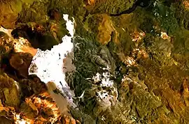 The Cerro Bayo volcanic complex lies along the Chile-Argentina border east of the Salar de Gorbea, the light-colored area at the left-center portion of this NASA Landsat image. A young well-preserved crater can be seen NE of an older snow-covered center (bottom-center). A younger northern center along the national border has a well-preserved 400-m-wide crater. | |
| Highest point | |
| Elevation | 5,401 m (17,720 ft) |
| Coordinates | 25°25′S 68°35′W |
| Geography | |
| Location | Argentina-Chile |
| Parent range | Andes |
| Geology | |
| Mountain type | Complex volcano |
| Last eruption | Unknown |
See also
References
- Benison, Kathleen C. (1 February 2019). "The Physical and Chemical Sedimentology of Two High-Altitude Acid Salars in Chile: Sedimentary Processes In An Extreme Environment". Journal of Sedimentary Research. 89 (2): 149–150. doi:10.2110/jsr.2019.9. ISSN 1527-1404.
- González-Ferrán, Oscar (1995). Volcanes de Chile. Santiago, Chile: Instituto Geográfico Militar. p. 640 pp. ISBN 978-956-202-054-1. (in Spanish; also includes volcanoes of Argentina, Bolivia, and Peru)
- "Cerro Bayo". Global Volcanism Program. Smithsonian Institution.
- Froger, J.-L.; Remy, D.; Bonvalot, S.; Legrand, D. (March 2007). "Two scales of inflation at Lastarria-Cordon del Azufre volcanic complex, central Andes, revealed from ASAR-ENVISAT interferometric data". Earth and Planetary Science Letters. 255 (1–2): 148–163. doi:10.1016/j.epsl.2006.12.012.
This article is issued from Wikipedia. The text is licensed under Creative Commons - Attribution - Sharealike. Additional terms may apply for the media files.
