Cerro Largo Department
Cerro Largo Department (Spanish pronunciation: [ˈsero ˈlaɾɣo]) is a department of Uruguay. Its capital is Melo. It is located in the east of the country, bordering Brazil to its northeast with Yaguaron River as the natural border, Treinta y Tres Department to its south, Durazno Department to its west and the departments of Tacuarembó and Rivera to its northwest with Negro River as its natural border with them.
Cerro Largo Department | |
|---|---|
 Flag  Coat of arms | |
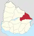
 Location of Cerro Largo Department and its capital | |
| Coordinates (Melo): 32°22′S 54°11′W | |
| Country | |
| Capital of Department | Melo |
| Government | |
| • Intendant | Sergio Botana |
| • Ruling party | Partido Nacional |
| Area | |
| • Total | 13,648 km2 (5,270 sq mi) |
| Population (2011 census) | |
| • Total | 84,698 |
| • Density | 6.2/km2 (16/sq mi) |
| Demonym(s) | arachán, cerrolarguense |
| Time zone | UTC-3 (UYT) |
| ISO 3166 code | UY-CL |
| Website | Official site |

History
At the end of the 18th century, apart from the indigenous people, the area was populated by the Spanish and the Portuguese alike. In 1795, the Captain of the Spanish Infantry Agustín de la Rosa founded the town of Melo, a fortress to repel attacks of the Portuguese and the Indios. The territory was invaded by the Portuguese in 1801, 1811, and 1816. The history of this place is marked by battles before, during and after the Independence of the Republic.[1]
The old Posta del Chuy, 15 kilometres (9.3 mi) from the town, was the historic Inn where travellers from Melo to Villa Artigas (the actual Río Branco) could rest and pay the fares for using the first public work of the Republic, the stone bridge over the stream Chuy del Tacuarí, today a Heritage Monument, built in 1855 by the French Basque brothers Etcheverry.[1]
In 1830, when Uruguay was divided in nine departments, Cerro Largo was one of them, including the biggest part of what was later separated as the Treinta y Tres Department.
During the 19th and early 20th centuries, when intermittent periods of civil war occurred in Uruguay, the department was a stronghold of the Blanco party. This was the precursor of the Partido Nacional.
Local people are usually known as "arachanes", in memory of an extinct local ethnicity, the Arachán people.
Population and Demographics
As of the census of 2011, Cerro Largo Department had a population of 84,698 (41,050 male and 43,648 female) and 35,841 households.[3]
Demographic data for Florida Department in 2010:
- Population growth rate: 0.571%
- Birth Rate: 15.95 births/1,000 people
- Death Rate: 8.64 deaths/1,000 people
- Average age: 32.1 (31.0 male, 33.0 female)
- Life Expectancy at Birth:
- Total population: 75.86 years
- Male: 72.58 years
- Female: 79.04 years
- Average per household income: 18,880 pesos/month
- Urban per capita income: 7,801 pesos/month
2010 Data Source:[4]
| Main Urban Centres | Other towns and villages | ||||||||||||||||||||||||||
|---|---|---|---|---|---|---|---|---|---|---|---|---|---|---|---|---|---|---|---|---|---|---|---|---|---|---|---|
| Population stated according to the 2011 census.[5] | |||||||||||||||||||||||||||
|
| ||||||||||||||||||||||||||
- Rural population
According to the 2011 census, Cerro Largo department has a rural population of 5,936.[3]
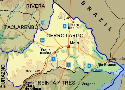
Map of the department

Prominent local people
- Aparicio Saravia was a prominent National (Blanco) Party leader, who died following the Battle of Masoller in 1904.
- Villanueva Saravia was a regional National (Blanco) Party leader.
- Rodolfo Nin Novoa has been Vice President of Uruguay (2005-2010).
Bibliography
- Domínguez, Carlos María (2004). El norte profundo (in Spanish). Montevideo: Ediciones de la Banda Oriental.
References
- "Historia de Cerro Largo". Intendencia de Cerro Largo. 2012. Retrieved 17 September 2012.
- "Población por sexo y ascendencia étnico racial, según departamento" (in Spanish). National Institute of Statistics. Archived from the original on 30 November 2020.
- "Censos 2011 Cerro Largo (needs flash plugin)". INE. 2012. Archived from the original on 6 June 2013. Retrieved 25 August 2012.
- "Uruguay en cifras" (PDF) (in Spanish). INE. 2011. Archived from the original (PDF) on 13 November 2012. Retrieved 25 October 2012.
- "Censos 2011 Cuadros Cerro Largo". INE. 2012. Archived from the original on 14 November 2012. Retrieved 25 August 2012.
External links
| Wikimedia Commons has media related to Cerro Largo Department. |
