Paysandú Department
Paysandú Department (Spanish pronunciation: [pajsanˈdu]) is a department of the northwestern region of Uruguay. It has an area of 13,922 km2 (5,375 sq mi) and a population of 113,124. Its capital is the city of Paysandú. It borders Salto Department to its north, Tacuarembó Department to its east, Río Negro Department to its south and has the Río Uruguay flowing at its west, separating it from Argentina.
Paysandú Department | |
|---|---|
 Flag  Coat of arms | |
 Location of Paysandú Department and its capital | |
| Coordinates (Paysandú): 32°19′S 58°4′W | |
| Country | |
| Capital of Department | Paysandú |
| Government | |
| • Intendant | Nicolás Olivera |
| • Ruling party | Partido Nacional |
| Area | |
| • Total | 13,922 km2 (5,375 sq mi) |
| Population (2011 census) | |
| • Total | 113,124 |
| • Density | 8.1/km2 (21/sq mi) |
| Demonym(s) | Sanducero |
| Time zone | UTC-3 (UYT) |
| ISO 3166 code | UY-PA |
| Website | paysandu.gub.uy |
The origin of its name is debated but is likely to be of Charrúa origin.
History
The first division of the Republic in six departments happened on 27 January 1816. Two more departments were formed later that year. At that time, Paysandú Department included all the territory north of the Río Negro, which included the actual departments of Artigas, Rivera, Tacuarembó, Salto, Paysandú, and Río Negro. On 17 June 1837, a new division of Uruguay was made and this territory was divided into three parts. In the new division, Paysandú Department included also the actual department of Río Negro, until it was split from it in 1868.
Population and demographics
As of the census of 2011, Paysandú Department had a population of 113,124 (55,361 male and 57,759 female) and 42,849 households.[2]
Demographic data for Paysandú Department in 2010:
- Population growth rate: 0.250%
- Birth Rate: 16.84 births/1,000 people
- Death Rate: 8.34 deaths/1,000 people
- Average age: 30.8 (29.1 male, 32.7 female)
- Life Expectancy at Birth:
- Total population: 77.03 years
- Male: 73.78 years
- Female: 80.67 years
- Average per household income: 24,543 pesos/month
- Urban per capita income: 9,457 pesos/month
2010 Data Source:[3]
| Main Urban Centres | Other towns and villages | ||||||||||||||||||||||||||||||||||||||||||||
|---|---|---|---|---|---|---|---|---|---|---|---|---|---|---|---|---|---|---|---|---|---|---|---|---|---|---|---|---|---|---|---|---|---|---|---|---|---|---|---|---|---|---|---|---|---|
| Population stated according to the 2011 census.[4] | |||||||||||||||||||||||||||||||||||||||||||||
|
| ||||||||||||||||||||||||||||||||||||||||||||
- Rural population
According to the 2011 census, Paysandú Department has an additional rural population of 4,364.[2]
Economy
The fertile soils of Paysandú have encouraged much agricultural development. Livestock raising is one of the principal agricultural activities, with cattle being raised for both the dairy and beef industries alongside sheep for wool production. Market-gardening is also prominent with the cultivation of oranges and blueberries, whilst wheat, barley, sunflowers and soya beans are also produced. There is also a small fishing industry on the Uruguay River.
Tourism too, is important for the area. Ecotourism is gaining prominence especially in the Esteros de Farrapos National Park further down the river. In addition many farms provide accommodation and facilities for tourists visiting the area.
Paysandú is home to a large brewery and hosts an annual Semana de la Cerveza (Week of the Beer), a weeklong festival of music, arts, carnival type rides, and beer.
Map of the department

References
- "Población por sexo y ascendencia étnico racial, según departamento" (in Spanish). National Institute of Statistics. Archived from the original on 30 November 2020.
- "Censos 2011 Paysandú (needs flash plugin)". INE. 2012. Retrieved 31 August 2012.
- "Uruguay en cifras" (PDF) (in Spanish). INE. 2011. Retrieved 25 October 2012.
- "Censos 2011 Cuadros Paysandú". INE. 2012. Retrieved 25 August 2012.
External links
| Wikimedia Commons has media related to Paysandú Department. |
- INE map of Paysandú Department Archived 2012-10-10 at the Wayback Machine
- Nuestra Terra, Colección Los Departamentos, Vol.11 "Paysandú"
Capital: Paysandú | ||
| Towns and villages | 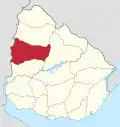 | |
| Sights | ||