Chée
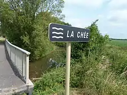
The Chée (French: la Chée) is a 68.6-kilometre (42.6 mi) long river in the Meuse and Marne départements, northeastern France.[1] Its source is in the Barrois, near Marat-la-Grande, a hamlet in Les Hauts-de-Chée. It flows generally southwest. It is a right tributary of the Saulx into which it flows at Vitry-en-Perthois, near Vitry-le-François.
| Chée | |
|---|---|
 | |
| Location | |
| Country | France |
| Physical characteristics | |
| Source | |
| • location | Les Hauts-de-Chée |
| • coordinates | 48°52′43″N 05°12′56″E |
| • elevation | 250 m (820 ft) |
| Mouth | |
• location | Saulx |
• coordinates | 48°45′08″N 04°38′47″E |
• elevation | 95 m (312 ft) |
| Length | 68.6 km (42.6 mi) |
| Basin size | 400 km2 (150 sq mi) |
| Discharge | |
| • average | 4 m3/s (140 cu ft/s) |
| Basin features | |
| Progression | Saulx→ Marne→ Seine→ English Channel |
Its main tributary is the Vière.
Départements and communes along its course
This list is ordered from source to mouth:
- Meuse: Les Hauts-de-Chée, Rembercourt-Sommaisne, Louppy-le-Château, Villotte-devant-Louppy, Laheycourt, Noyers-Auzécourt, Nettancourt, Brabant-le-Roi, Revigny-sur-Ornain
- Marne: Vroil, Bettancourt-la-Longue, Alliancelles, Heiltz-le-Maurupt, Jussecourt-Minecourt, Heiltz-l'Évêque, Outrepont, Changy, Merlaut, Vitry-en-Perthois
Notes
- This article is based on the equivalent article from the French Wikipedia, consulted on 20 April 2009.
References
This article is issued from Wikipedia. The text is licensed under Creative Commons - Attribution - Sharealike. Additional terms may apply for the media files.