Rembercourt-Sommaisne
Rembercourt-Sommaisne is a commune in the Meuse department in Grand Est in northeastern France.
Rembercourt-Sommaisne | |
|---|---|
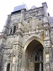 Saint-Louvent church | |
.svg.png.webp) Coat of arms | |
Location of Rembercourt-Sommaisne 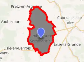
| |
 Rembercourt-Sommaisne  Rembercourt-Sommaisne | |
| Coordinates: 48°54′40″N 5°10′44″E | |
| Country | France |
| Region | Grand Est |
| Department | Meuse |
| Arrondissement | Bar-le-Duc |
| Canton | Revigny-sur-Ornain |
| Intercommunality | Communauté de communes de Triaucourt Vaubecourt |
| Government | |
| • Mayor (2008–2014) | Olivier Poutrieux |
| Area 1 | 22.32 km2 (8.62 sq mi) |
| Population (2017-01-01)[1] | 353 |
| • Density | 16/km2 (41/sq mi) |
| Time zone | UTC+01:00 (CET) |
| • Summer (DST) | UTC+02:00 (CEST) |
| INSEE/Postal code | 55423 /55250 |
| Elevation | 223–307 m (732–1,007 ft) |
| 1 French Land Register data, which excludes lakes, ponds, glaciers > 1 km2 (0.386 sq mi or 247 acres) and river estuaries. | |
Rembercourt-Sommaisne was created on 1 January 1973 when the former communes of Rembercourt-aux-Pots and Sommaisne were joined together.
Geography
The Chée forms part of the commune's southern border.
The Aisne rises near Sommaisne, a hamlet in the northern part of the commune.
See also
References
- "Populations légales 2017". INSEE. Retrieved 6 January 2020.
| Wikimedia Commons has media related to Rembercourt-Sommaisne. |
| Authority control |
|---|
This article is issued from Wikipedia. The text is licensed under Creative Commons - Attribution - Sharealike. Additional terms may apply for the media files.