Champlain Park
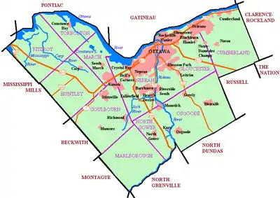
Champlain Park (French: Parc Champlain; also known as Ottawa West[2]) is an older urban neighbourhood in Kitchissippi Ward in Ottawa, Ontario, Canada. It was considered in the 1930s as the west end of town. The boundaries of the neighbourhood are the Ottawa River (to the north) and Scott Street (to the south). To the east is Tunney's Pasture and to the west is Island Park Drive.[3][4] Westboro Beach is also to the west. The population as of the 2016 Census was 1090.[5]
Champlain Park | |
|---|---|
Neighbourhood | |
 Champlain Park | |
 Champlain Park | |
| Coordinates: 45.40268°N 75.74565°W | |
| Country | Canada |
| Province | Ontario |
| City | Ottawa |
| Government | |
| • MPs | Catherine McKenna |
| • MPPs | Joel Harden |
| • Councillors | Jeff Leiper |
| • Governing body | Champlain Park Community Association |
| • Co-Chair | Heather Pearl[1] |
| Area | |
| • Total | 1.047 km2 (0.404 sq mi) |
| Elevation | 60 m (200 ft) |
| Population | |
| • Total | 1,090 |
| • Density | 1,000/km2 (2,700/sq mi) |
| Time zone | Eastern (EST) |
| Website | Community Association |
The area was part of the police village of Ottawa West from 1912 until being annexed by Ottawa in 1949. The police village was bounded by Ottawa's city limits, the Ottawa River and the Briannia street car line.[6] Most of the homes were built in the 1920s and 1930s, with the last development in the 1950s. The community association was incorporated in 1991.[7]
Notable buildings include St. George Elementary School, the Ottawa mosque where the Ottawa Muslim Association has their meetings, and the adjacent Hall of Peace, formerly Northwestern United Church.
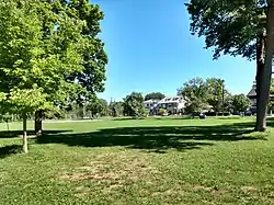
Recreation
For recreation there is Champlain Park, and the NCC (National Capital Commission) bike path.
References
- https://champlainpark.org/the-cpca-organization/
- "Ottawa West". Geographical Names Data Base. Natural Resources Canada.
- http://ourkitchissippi.ca/our-community/community-associations/
- https://champlainpark.org/our-neighbourhood-2/
- Population calculated by combining Dissemination Areas 35061869 and 35061873
- "Ottawa West again asking annexation". Ottawa Citizen. March 4, 1926.
- https://champlainpark.files.wordpress.com/2011/12/champlain-park-ca-incorporation-original-letters-patent.pdf
Places adjacent to Champlain Park | ||||||||||
|---|---|---|---|---|---|---|---|---|---|---|
| ||||||||||
