Changgang County
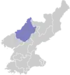
Changgang County is a kun, or county, in north-central Chagang province, North Korea. Originally part of Kanggye, it was made a separate county in 1949. It borders Hwapyong and Nangrim to the east, Kanggye and Sijung to the west, Songgan to the south, and Chasong to the north.
Changgang County
장강군 | |
|---|---|
| Korean transcription(s) | |
| • Hanja | 長江郡 |
| • McCune-Reischauer | Changgang kun |
| • Revised Romanization | Janggang-gun |
 Map of Chagang showing location of Changgang | |
| Country | North Korea |
| Province | Chagang Province |
| Administrative divisions | 1 ŭp, 3 workers' districts, 10 ri |
| Area | |
| • Total | 740 km2 (290 sq mi) |
| Population (1991 est.) | |
| • Total | 67,000 |
The terrain of Changgang is rugged and mountainous, with the Kangnam Mountains in the northeast and the Chogyuryong Mountains in the southwest. The highest peak is Kumpasan (금파산, 1918 m) along the northern border.
Changgang is served by road and rail, with the Kanggye Line railroad passing through the southeast. There are soft-drink and pharmaceutical factories in the county. Rice is grown along the Chongsong River (종성강); other grains as well as grapes are grown in the highlands. Zinc is mined.
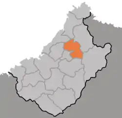
Administrative divisions
Changgang county is divided into 1 ŭp (town), 3 rodongjagu (workers' districts) and 10 ri (villages):
|
|
External links
- Satellite view
- (in Korean) In Korean language online encyclopedias: