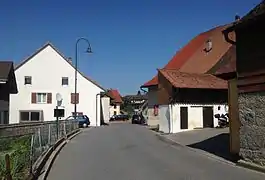
Cheyres-Châbles
Cheyres-Châbles is a municipality in the district of Broye in the canton of Fribourg in Switzerland. On 1 January 2017 the former municipalities of Châbles and Cheyres merged into the new municipality of Cheyres-Châbles.[2]
Cheyres-Châbles | |
|---|---|
 | |
 Coat of arms | |
Location of Cheyres-Châbles 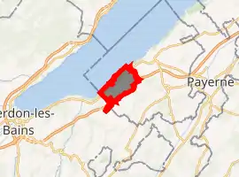
| |
 Cheyres-Châbles Cheyres-Châbles | |
| Coordinates: 46°50′N 6°48′E | |
| Country | Switzerland |
| Canton | Fribourg |
| District | Broye |
| Government | |
| • Mayor | Syndic |
| Area | |
| • Total | 9.87 km2 (3.81 sq mi) |
| Population (2018-12-31)[1] | |
| • Total | 2,320 |
| • Density | 240/km2 (610/sq mi) |
| Time zone | UTC+01:00 (Central European Time) |
| • Summer (DST) | UTC+02:00 (Central European Summer Time) |
| Postal code(s) | 1474, 1468 |
| SFOS number | 2055 |
| Surrounded by | Bollion, Châtillon, Concise (VD), Font, Murist, Vaumarcus (NE) |
| Website | http://www.cheyres-chables.ch SFSO statistics |
History
Cheyres
Cheyres is first mentioned in 1230 as Cheres.[3]
Geography
Cheyres-Châbles has an area, as of 2009, of 9.74 km2 (3.76 sq mi).[4]
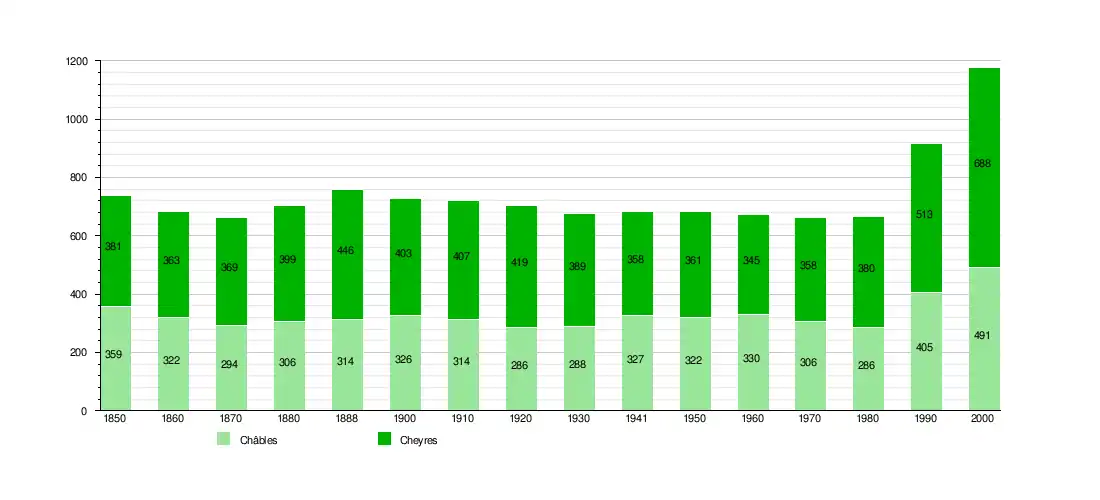
Demographics
The new municipality has a population (as of December 2019) of 2,317.[5]
Sights
The entire Font region (shared between Châbles and Font) is designated as part of the Inventory of Swiss Heritage Sites[7]
References
- "Ständige Wohnbevölkerung nach Staatsangehörigkeitskategorie Geschlecht und Gemeinde; Provisorische Jahresergebnisse; 2018". Federal Statistical Office. 9 April 2019. Retrieved 11 April 2019.
- Amtliches Gemeindeverzeichnis der Schweiz (in German) accessed 29 November 2016
- Cheyres in German, French and Italian in the online Historical Dictionary of Switzerland.
- Arealstatistik Standard - Gemeindedaten nach 4 Hauptbereichen
- "Ständige und nichtständige Wohnbevölkerung nach institutionellen Gliederungen, Geburtsort und Staatsangehörigkeit". bfs.admin.ch (in German). Swiss Federal Statistical Office - STAT-TAB. 31 December 2019. Retrieved 6 October 2020.
- Swiss Federal Statistical Office STAT-TAB Bevölkerungsentwicklung nach institutionellen Gliederungen, 1850-2000 (in German) accessed 27 April 2016
- "Kantonsliste A-Objekte". KGS Inventar (in German). Federal Office of Civil Protection. 2009. Archived from the original on 28 June 2010. Retrieved 25 April 2011.
External links
| Wikimedia Commons has media related to Cheyres-Châbles. |
- Châbles in German, French and Italian in the online Historical Dictionary of Switzerland.
Municipalities in Broye District, Switzerland | ||
|---|---|---|
This article is issued from Wikipedia. The text is licensed under Creative Commons - Attribution - Sharealike. Additional terms may apply for the media files.
