Choluteca, Choluteca
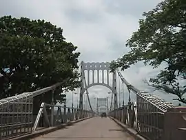
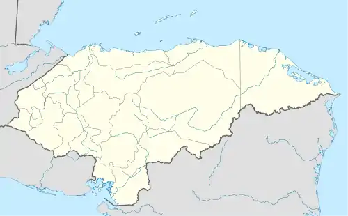
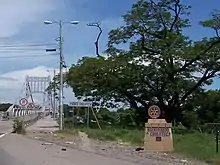
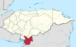
Choluteca is a municipality and the capital city of the Honduran department of the same name. Situated in southern Honduras between El Salvador and Nicaragua, the city is generally considered the regional centre of southern Honduras and is a major transit point on the Pan-American Highway. It has a major bus station and is home to the regional light (ENEE) and water (SANAA) utilities. The city is located on the Choluteca River,[2] near the centre of the department. An arching silver bridge crosses the river into the city.
Choluteca | |
|---|---|
Municipality | |
 | |
| Nicknames: Cholu, Cholutexas | |
 Choluteca | |
| Coordinates: 13°18′10″N 87°11′00″W | |
| Country | |
| Departament | Choluteca |
| Municipality | Choluteca |
| Founded | 1522 |
| Villa Title | 1585 |
| City Title | 1845 |
| Government | |
| • Type | Democratic Municipality |
| • Mayor | Quintín Soriano |
| • Vice-Mayor | Martha Margarita Oyuela |
| Area | |
| • Municipality | 1,072 km2 (414 sq mi) |
| Population (2020 projection)[1] | |
| • Municipality | 168,898 |
| • Density | 160/km2 (410/sq mi) |
| • Urban | 111,777 |
| Abbreviation | Cholu |
Choluteca's population of 96,410 (2020 calculation)[3] makes it the seventh largest city in the country. It is the only major Honduran city on the Pan-American Highway. It is considered to be the second-hottest city in Honduras after Nacaome.
History
When Spanish conquistadors arrived in southern Honduras in 1535, the Chorotega indigenous people inhabited the area. In 1541, a town was founded there by Captain Cristobál de la Cueva which was known as Villa de Xerez de la Frontera de Choluteca.[4] The conquistadors had a practice of establishing colonies in their territories in strategic locations to dominate and take over the land from the indigenous people.[5] With the founding of Xerex de la Frontera, that strategy was used to possess a communication center with the sister republics of Guatemala and Nicaragua.[6] Like other parts of Honduras, the Choluteca area had many mineral deposits[5][7] and fertile land for agriculture, making it one of the richest colonies of Honduras for the Spanish government.
From its founding, Villa de Xerez de la Frontera depended on the Guatemalan government, but in 1580, it became part of the Tegucigalpa, Honduras municipality. Under the Honduran president Coronado Chávez, the city was officially named “Choluteca” on October 1, 1845 by the National Congress of the Republic.
There are many versions of Choluteca’s founding. Federico Lunardi says it was established in 1535,[8] Rómulo Ernesto Durón says 1533, and Doris Stone says 1540.[9] The modern historian Marxis Lenin Hernández says there is a need to investigate the real origin of Choluteca because of these discrepancies. He says that Federico Lunardi’s version of the history is the most widespread.

Over the years, Choluteca has developed into one of the country’s most important centers of history, culture, and commerce.

Choluteca was heavily damaged by flooding from Hurricane Mitch in 1998. It received more rainfall than any other place affected by the storm – 36 inches in only a few days. This is the amount of rain the city normally receives in 212 days. In addition, the Choluteca River swelled to six times its normal width, putting entire neighbourhoods under water temporarily.[2] Many villages and suburbs, like Stevensville, were badly damaged, suffering immense property losses and a high number of deaths.
The charity Solar net Village helped to rebuild San Ramón, Choluteca[10] and restored electricity in San Francisco, Lempira.[11]
Choluteca is one of the most productive areas of Honduras. The department raises commodity crops of sugar, cantaloupe, watermelon, okra, and sweet potato. It also harvests shrimp and fish, and produces salt, and a few precious metals.
José Cecilio del Valle, the first President of Central America, was born in Choluteca in 1780. His house (Casa Valle, located on the main square) is now a cultural centre housing the local library and a tourist centre. The house is featured on the back of the 100-lempira note.
Dania Prince, Miss Earth 2003 and the only Honduran to win a grandslam beauty pageant, came from Choluteca.
Climate
| Climate data for Choluteca, Choluteca (1961–1990) | |||||||||||||
|---|---|---|---|---|---|---|---|---|---|---|---|---|---|
| Month | Jan | Feb | Mar | Apr | May | Jun | Jul | Aug | Sep | Oct | Nov | Dec | Year |
| Record high °C (°F) | 36.8 (98.2) |
37.7 (99.9) |
39.0 (102.2) |
39.6 (103.3) |
38.7 (101.7) |
36.0 (96.8) |
36.5 (97.7) |
36.5 (97.7) |
35.1 (95.2) |
34.7 (94.5) |
35.6 (96.1) |
36.0 (96.8) |
39.6 (103.3) |
| Average high °C (°F) | 34.6 (94.3) |
35.7 (96.3) |
36.7 (98.1) |
35.1 (95.2) |
35.1 (95.2) |
33.1 (91.6) |
34.1 (93.4) |
34.1 (93.4) |
32.6 (90.7) |
32.6 (90.7) |
33.5 (92.3) |
34.3 (93.7) |
34.3 (93.7) |
| Daily mean °C (°F) | 28.6 (83.5) |
29.2 (84.6) |
30.1 (86.2) |
30.5 (86.9) |
29.2 (84.6) |
28.1 (82.6) |
28.8 (83.8) |
28.6 (83.5) |
27.4 (81.3) |
27.6 (81.7) |
28.1 (82.6) |
28.4 (83.1) |
28.7 (83.7) |
| Average low °C (°F) | 23.1 (73.6) |
23.0 (73.4) |
23.5 (74.3) |
24.5 (76.1) |
24.2 (75.6) |
23.4 (74.1) |
23.8 (74.8) |
23.6 (74.5) |
22.9 (73.2) |
22.8 (73.0) |
22.7 (72.9) |
23.0 (73.4) |
23.4 (74.1) |
| Record low °C (°F) | 19.7 (67.5) |
20.0 (68.0) |
20.4 (68.7) |
21.8 (71.2) |
21.7 (71.1) |
21.6 (70.9) |
21.2 (70.2) |
21.1 (70.0) |
21.2 (70.2) |
21.1 (70.0) |
20.5 (68.9) |
19.6 (67.3) |
19.6 (67.3) |
| Average rainfall mm (inches) | 2.0 (0.08) |
5.2 (0.20) |
7.5 (0.30) |
31.0 (1.22) |
286.2 (11.27) |
267.3 (10.52) |
139.4 (5.49) |
244.6 (9.63) |
358.7 (14.12) |
275.6 (10.85) |
77.2 (3.04) |
8.5 (0.33) |
1,703.2 (67.06) |
| Average rainy days (≥ 1.0 mm) | 0 | 1 | 8 | 3 | 13 | 17 | 10 | 14 | 20 | 15 | 4 | 1 | 106 |
| Mean monthly sunshine hours | 292.9 | 272.0 | 291.2 | 242.7 | 235.6 | 211.1 | 232.6 | 234.3 | 194.8 | 233.3 | 246.1 | 274.2 | 2,960.8 |
| Source: NOAA[12] | |||||||||||||
See also
References
- Citypopulation.de Population of departments and municipalities in Honduras
- "Honduras – Geografía y Población". FAO. 2000. Retrieved 25 May 2009.
- Citypopulation.de Population of the major cities in Honduras
- Larde, Jorge; Larín, Jorge (1978). "TOPONIMIA CENTROAMERICANA (CHOLUTECA, MANALACO Y CHOROTEGA)". Anuario De Estudios Centroamericanos. 4: 207–217. JSTOR 25661655.
- de Oyuela, Leticia (1995). Honduras: Religiosidad Popular, Raiz de la Identidad. Choluteca, Honduras C. A.: Centro de Publicaciones Obispado de Choluteca. pp. 43–47.
- Secoff, Mario. "DEPARTAMENTO DE CHOLUTECA". El Libro Electronico de Honduras.
- Koebel, William Henry (1917). Central America: Guatemala, Nicaragua, Costa Rica, Honduras, Panama, and Salvador. London, England: T. Fisher Unwin LTD. pp. 244–259.
- Lunardi, Federico (1948). Honduras Maya: etnologia y arqueologia de Honduras: estudios Mayas: orientaciones. Tegucigalpa: Secretaria privada de la Presidencia de la Republica.
- Stone, Doris (1957). The Archaeology of Central and Southern Honduras. Cambridge, Massachusetts: Peabody Museum.
- "Remote Energy Systems and Rural Connectivity: Technical Assistance to the Aldeas Solares Program of Honduras" (PDF). ESMAP. December 2005. Retrieved 16 January 2019.
- "Lempira Honduras - Rural Electrification - Electrification". Scribd.
- "Choluteca Climate Normals 1961–1990". National Oceanic and Atmospheric Administration. Retrieved 24 January 2016.
External links
| Wikimedia Commons has media related to Choluteca. |
