Civic Hospital
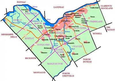
Civic Hospital (French: Hôpital Civic[2]) is a neighbourhood in Kitchissippi Ward in central Ottawa, Canada. It is named after the Ottawa Civic Hospital, which is located in the neighbourhood.
Civic Hospital | |
|---|---|
Neighbourhood | |
 The Civic Pharmacy Building sign is a neighbourhood landmark. | |
 Civic Hospital | |
| Coordinates: 45.394°N 75.725°W | |
| Country | Canada |
| Province | Ontario |
| City | Ottawa |
| Government | |
| • MPs | Catherine McKenna |
| • MPPs | Joel Harden |
| • Councillors | Jeff Leiper |
| • Governing body | Civic Hospital Neighbourhood Association |
| • President | Karen Wright[1] |
| Area | |
| • Total | 1.27 km2 (0.49 sq mi) |
| Elevation | 75 m (246 ft) |
| Population | |
| • Total | 5,062 |
| • Density | 4,000/km2 (10,000/sq mi) |
| Time zone | Eastern (EST) |
| Forward sortation areas | K1S, K1Y |
| Website | Neighbourhood Association |
Civic Hospital is bounded on the west by Island Park Drive, on the north by the Queensway, on the east by Railway Street and on the south by Carling Avenue.[3] The population as of the Canada 2016 Census was 5,062.[4]

Community
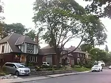
Civic Hospital is primarily a residential neighbourhood; the Civic Hospital and a small number of office and commercial buildings line Carling Avenue along the area's southern edge. The 1960 Googie-inspired Civic Pharmacy Building sign at the corner of Carling and Holland Avenues is a local landmark.[5] The community is known for its many high-quality "Younghusband" homes, built by David Younghusband between 1939 and 1947.[6] Residents may belong to the Civic Hospital Neighbourhood Association, which organises events and activities to improve the community.
History
The area first opened to settlement in 1801, and was originally known as Bayswater. It was annexed by Ottawa in 1907.[7] Most of the homes at the time were along Loretta Street and Champagne Avenue, north of Beech Street.[8] It continued to be known as Bayswater after annexation,[9] but the name would fall out of use as the neighbourhood expanded. The Civic Hospital Homeowners Association was established in 1973 and the Civic Hospital Neighbourhood Association was established in 1982.[10]
Transportation
The main streets within the neighbourhood are Parkdale Avenue, Sherwood Drive, Kenilworth Drive and Holland Avenue. The neighbourhood is served by Carling Station on the O-Train Trillium Line, frequent bus service on Holland and Parkdale Avenues that will connect to the Confederation Line at Tunney's Pasture Station in 2018, and crosstown routes on Carling Avenue.[11]
Education
Civic Hospital schoolchildren may attend one of five elementary schools, St George (Junior Kindergarten - Grade 6),[12] Elmdale Public School (JK - Grade 6), Fisher Park Public/Summit Alternative School (Grades 7-8), Devonshire Public School (JK - Grade 6) and Connaught Public School (JK - Grade 6),[13] all of which are in adjacent neighbourhoods.
Places adjacent to Civic Hospital | |
|---|---|
References
- http://www.chnaottawa.ca/chna-board-of-directors.html
- "Official Cycling Map Ottawa-Gatineau and the Outaouais Region" (PDF). National Capital Commission. Retrieved 5 December 2017.
- "About Us". Civic Hospital Neighbourhood Association. Retrieved 5 December 2017.
- Population calculated by combining Census Tract 5050034.00 with Dissemination area 35061760 and Dissemination Blocks 35061761002, 35061761001, 35061762001, 35061762002 and removing 35061690019, 35061690017 and 35061690018
- King, Andrew. "The Mid-Century Modern Civic Pharmacy Building Is For Sale". Ottawa Rewind. Retrieved 19 January 2018.
- "Civic Hospital Neighbourhood Tour". Civic Hospital Neighbourhood Association History and Heritage Committee. Retrieved 30 June 2017.
- "Timeline" (PDF). Civic Hospital Neighbourhood Association History and Heritage Committee. Retrieved 30 June 2017.
- Ottawa, Ontario. 1:63,360. Map Sheet 031G05, [ed. 1], 1906; Producer: Survey Division, Department of Militia and Defence; Date published: 1906-01-01 (publication), 2016-01-01 (publication)
- Ottawa, Ontario. 1:63,360. Map Sheet 031G05, [ed. 6], 1922; Producer: Survey Division, Department of Militia and Defence; Date published: 1922-01-01 (publication), 2016-01-01 (publication)
- http://www.chnaottawa.ca/about-us.html
- "New Service Types". Ready for Rail. OC Transpo. Retrieved 30 June 2017.
- "St George Catholic Elementary School boundary map". Ottawa Catholic School Board. Retrieved 30 June 2017.
- "Elementary Attendance Boundary Maps". Ottawa-Carleton District School Board. Archived from the original on 19 January 2018. Retrieved 19 January 2018.
