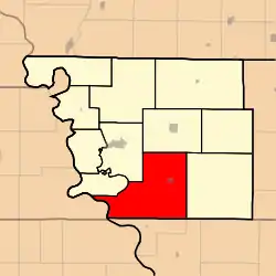
Clark Township, Atchison County, Missouri
Clark Township is one of eleven townships in Atchison County, Missouri, United States. As of the 2010 census, its population was 895.[3]
Clark Township | |
|---|---|
 | |
| Coordinates: 40°20′00″N 095°24′31″W | |
| Country | |
| State | |
| County | Atchison |
| Area | |
| • Total | 195.21 km2 (75.37 sq mi) |
| • Land | 194.38 km2 (75.05 sq mi) |
| • Water | 0.83 km2 (0.32 sq mi) 0.43% |
| Elevation | 276 m (906 ft) |
| Population (2010) | |
| • Total | 895 |
| • Density | 4.6/km2 (12/sq mi) |
| FIPS code | 29-13996[2] |
| GNIS feature ID | 0766232 |
Clark Township was established in 1845.[4]
Geography
Clark Township covers an area of 75.4 square miles (195.2 km2) and contains one incorporated settlement, Fairfax. It contains five cemeteries: Beck, Corning, Mount Hope, Pleasant Ridge and Pleasant Ridge.
The streams of Cow Branch, Old Channel Nishnabotna River and Rock Creek run through this township.
Transportation
Clark Township contains one airport, Steele Airport.
References
- "US Board on Geographic Names". United States Geological Survey. 2007-10-25. Retrieved 2008-01-31.
- "U.S. Census website". United States Census Bureau. Retrieved 2008-01-31.
- "Geographic Identifiers: 2010 Demographic Profile Data (G001): Clark township, Atchison County, Missouri". U.S. Census Bureau, American Factfinder. Archived from the original on February 12, 2020. Retrieved June 25, 2013.
- "Atchison County Place Names, 1928-1945 (archived)". The State Historical Society of Missouri. Archived from the original on 24 June 2016. Retrieved 30 August 2016.CS1 maint: bot: original URL status unknown (link)
External links
Municipalities and communities of Atchison County, Missouri, United States | ||
|---|---|---|
| Cities | 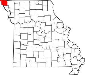 Map of Missouri highlighting Atchison County | |
| Village | ||
| Townships | ||
| CDPs | ||
| Unincorporated communities | ||
| Ghost towns | ||
| ||
This article is issued from Wikipedia. The text is licensed under Creative Commons - Attribution - Sharealike. Additional terms may apply for the media files.