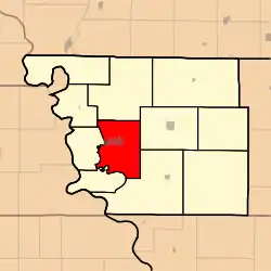
Clay Township, Atchison County, Missouri
Clay Township is one of eleven townships in Atchison County, Missouri, United States. As of the 2010 census, its population was 1,798.[3]
Clay Township | |
|---|---|
 | |
| Coordinates: 40°25′20″N 095°31′03″W | |
| Country | |
| State | |
| County | Atchison |
| Area | |
| • Total | 108.85 km2 (42.03 sq mi) |
| • Land | 108.80 km2 (42.01 sq mi) |
| • Water | 0.06 km2 (0.02 sq mi) 0.05% |
| Elevation | 319 m (1,047 ft) |
| Population (2010) | |
| • Total | 1,798 |
| • Density | 16.5/km2 (43/sq mi) |
| FIPS code | 29-14284[2] |
| GNIS feature ID | 0766233 |
Clay Township was organized in 1856, and named after Henry Clay of Kentucky.[4]
Geography
Clay Township covers an area of 42.0 square miles (108.9 km2) and contains one incorporated settlement, Rock Port (the county seat). It contains five cemeteries: Bush, Green Hill, Hunter, Millsap and Smith.
The streams of Boney Branch, Turkey Creek and Volger Branch run through this township.
Transportation
Clay Township contains one airport, Luhrs Landing Strip.
References
- "US Board on Geographic Names". United States Geological Survey. 2007-10-25. Retrieved 2008-01-31.
- "U.S. Census website". United States Census Bureau. Retrieved 2008-01-31.
- "Geographic Identifiers: 2010 Demographic Profile Data (G001): Clay township, Atchison County, Missouri". U.S. Census Bureau, American Factfinder. Archived from the original on February 12, 2020. Retrieved June 25, 2013.
- "Atchison County Place Names, 1928-1945 (archived)". The State Historical Society of Missouri. Archived from the original on 24 June 2016. Retrieved 30 August 2016.CS1 maint: bot: original URL status unknown (link)
External links
Municipalities and communities of Atchison County, Missouri, United States | ||
|---|---|---|
| Cities | 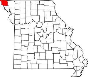 Map of Missouri highlighting Atchison County | |
| Village | ||
| Townships | ||
| CDPs | ||
| Unincorporated communities | ||
| Ghost towns | ||
| ||
This article is issued from Wikipedia. The text is licensed under Creative Commons - Attribution - Sharealike. Additional terms may apply for the media files.
