Clay Center, Kansas
Clay Center is a city in and the county seat of Clay County, Kansas, United States.[5] As of the 2010 census, the city population was 4,334.[6]
Clay Center, Kansas | |
|---|---|
City and County seat | |
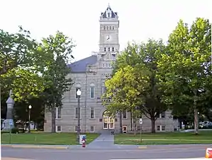 Clay County Courthouse (2006) | |
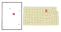 Location within Clay County and Kansas | |
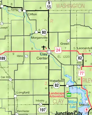 KDOT map of Clay County (legend) | |
| Coordinates: 39°22′48″N 97°7′23″W | |
| Country | United States |
| State | Kansas |
| County | Clay |
| Founded | 1862 |
| Incorporated | 1875 |
| Government | |
| • Mayor | James Thatcher |
| Area | |
| • Total | 3.19 sq mi (8.27 km2) |
| • Land | 3.19 sq mi (8.26 km2) |
| • Water | 0.00 sq mi (0.01 km2) |
| Elevation | 1,201 ft (366 m) |
| Population | |
| • Total | 4,334 |
| • Estimate (2019)[3] | 3,983 |
| • Density | 1,248.20/sq mi (481.97/km2) |
| Time zone | UTC-6 (CST) |
| • Summer (DST) | UTC-5 (CDT) |
| ZIP code | 67432 |
| Area code | 785 |
| FIPS code | 20-13625 |
| GNIS ID | 0476034 [4] |
| Website | cityofclaycenter.com |
History
Clay Center was first settled in 1862.[7] It was named from its position near the geographical center of Clay County.[8]
The first post office was established in Clay Center on July 3, 1862.[9]
Clay Center was located on the Chicago, Rock Island and Pacific and Union Pacific Railroads.[10]
Geography
Clay Center is located at 39°22′48″N 97°7′23″W (39.379920, -97.123168).[11] According to the United States Census Bureau, the city has a total area of 3.08 square miles (7.98 km2), all of it land.[12] Clay Center is unique, because it is the geographic midpoint between Los Angeles, California and New York City, the two largest American cities. Both cities are exactly 1,224 mi (1,970 km) from Clay Center.[13]
Climate
The climate in this area is characterized by hot, humid summers and generally mild to cool winters. According to the Köppen Climate Classification system, Clay Center has a humid subtropical climate, abbreviated "Cfa" on climate maps.[14]
Demographics
| Historical population | |||
|---|---|---|---|
| Census | Pop. | %± | |
| 1880 | 1,753 | — | |
| 1890 | 2,802 | 59.8% | |
| 1900 | 3,069 | 9.5% | |
| 1910 | 3,438 | 12.0% | |
| 1920 | 3,715 | 8.1% | |
| 1930 | 4,386 | 18.1% | |
| 1940 | 4,518 | 3.0% | |
| 1950 | 4,528 | 0.2% | |
| 1960 | 4,613 | 1.9% | |
| 1970 | 4,963 | 7.6% | |
| 1980 | 4,948 | −0.3% | |
| 1990 | 4,613 | −6.8% | |
| 2000 | 4,564 | −1.1% | |
| 2010 | 4,334 | −5.0% | |
| 2019 (est.) | 3,983 | [3] | −8.1% |
| U.S. Decennial Census[15] 2012 Estimate[16] | |||
2010 census
As of the census[2] of 2010, there were 4,334 people, 1,920 households, and 1,172 families living in the city. The population density was 1,407.1 inhabitants per square mile (543.3/km2). There were 2,158 housing units at an average density of 700.6 per square mile (270.5/km2). The racial makeup of the city was 96.9% White, 0.5% African American, 0.6% Native American, 0.3% Asian, 0.4% from other races, and 1.3% from two or more races. Hispanic or Latino of any race were 1.8% of the population.
There were 1,920 households, of which 27.0% had children under the age of 18 living with them, 48.8% were married couples living together, 8.2% had a female householder with no husband present, 4.0% had a male householder with no wife present, and 39.0% were non-families. 35.0% of all households were made up of individuals, and 20.1% had someone living alone who was 65 years of age or older. The average household size was 2.21 and the average family size was 2.82.
The median age in the city was 44.5 years. 22.5% of residents were under the age of 18; 6.6% were between the ages of 18 and 24; 21.4% were from 25 to 44; 25.8% were from 45 to 64; and 23.7% were 65 years of age or older. The gender makeup of the city was 48.6% male and 51.4% female.
2000 census
As of the census of 2000, there were 4,564 people, 1,979 households, and 1,258 families living in the city. The population density was 1,762.4 people per square mile (680.4/km2). There were 2,191 housing units at an average density of 846.0 per square mile (326.6/km2). The racial makeup of the city was 97.98% White, 0.64% African American, 0.33% Native American, 0.20% Asian, 0.07% from other races, and 0.79% from two or more races. Hispanic or Latino of any race were 0.53% of the population.
There were 1,979 households, out of which 27.0% had children under the age of 18 living with them, 52.6% were married couples living together, 7.2% had a female householder with no husband present, and 36.4% were non-families. 33.4% of all households were made up of individuals, and 19.7% had someone living alone who was 65 years of age or older. The average household size was 2.24 and the average family size was 2.83.
In the city, the population was spread out, with 23.0% under the age of 18, 7.3% from 18 to 24, 22.0% from 25 to 44, 22.5% from 45 to 64, and 25.1% who were 65 years of age or older. The median age was 43 years. For every 100 females, there were 94.0 males. For every 100 females age 18 and over, there were 88.7 males.
The median income for a household in the city was $31,531, and the median income for a family was $45,567. Males had a median income of $29,526 versus $16,149 for females. The per capita income for the city was $19,128. About 5.9% of families and 9.8% of the population were below the poverty line, including 12.5% of those under age 18 and 10.0% of those age 65 or over.
Area events
Piotique Festival – Held each year on the last Saturday of September, Piotique is a portmanteau of Pioneer and Antique. Each year, hundreds of people come to Clay Center. Participants enjoy food vendors, craft booths, activities, live entertainment, and dancing on the Clay County Courthouse lawn. The festival kicks off downtown at 7:30 AM with the Piotique Road race.[17]
Government
The Clay Center government consists of a mayor and eight council members, which meets twice a month.
Education
The community is served by Clay County USD 379 public school district, and Clay Center Community High School.
The Clay Center Carnegie Library is the public library for this community.
Notable people
- Herb Bradley, professional baseball player
- Tracy Claeys, Washington State football defensive coordinator and former University of Minnesota football head coach
- Warren Henry Cole, surgeon who pioneered X-ray use in medicine
- George Docking, former governor of Kansas
- Steve Doocy, host for Fox News, Fox & Friends TV talk show; author
- Tenney Frank, noted scholar and historian
- Lady Greyhound (dog), marketing mascot for Greyhound Lines in the late 1950s
- Nicole Ohlde, basketball player and WNBA player
- Otto D. Unruh, two-time Bethel College football coach and 21-year coaching career at Clay Center Kansas High School
- William D. Vincent, United States Representative
References
- "2019 U.S. Gazetteer Files". United States Census Bureau. Retrieved July 24, 2020.
- "U.S. Census website". United States Census Bureau. Retrieved 2012-07-06.
- "Population and Housing Unit Estimates". United States Census Bureau. May 24, 2020. Retrieved May 27, 2020.
- "US Board on Geographic Names". United States Geological Survey. 2007-10-25. Retrieved 2008-01-31.
- "Find a County". National Association of Counties. Archived from the original on 2011-05-31. Retrieved 2011-06-07.
- "2010 City Population and Housing Occupancy Status". U.S. Census Bureau. Retrieved March 27, 2011.
- Blackmar, Frank Wilson (1912). Kansas: A Cyclopedia of State History, Embracing Events, Institutions, Industries, Counties, Cities, Towns, Prominent Persons, Etc. Standard Publishing Company. pp. 361.
- Kansas State Historical Society (1916). Biennial Report of the Board of Directors of the Kansas State Historical Society. Kansas State Printing Plant. pp. 160.
- "Kansas Post Offices, 1828-1961 (archived)". Kansas Historical Society. Archived from the original on October 9, 2013. Retrieved 7 June 2014.
- "Geohydrology of Clay County". Kansas Geological Survey. Retrieved 2 August 2014.
- "US Gazetteer files: 2010, 2000, and 1990". United States Census Bureau. 2011-02-12. Retrieved 2011-04-23.
- "US Gazetteer files 2010". United States Census Bureau. Archived from the original on 2012-01-25. Retrieved 2012-07-06.
- ""As The Crow Flies" Distance Calculator". Tjpeiffer. Retrieved July 2014. Check date values in:
|access-date=(help) - Climate Summary for Clay Center, Kansas
- United States Census Bureau. "Census of Population and Housing". Retrieved February 14, 2014.
- "Annual Estimates of the Resident Population: April 1, 2010 to July 1, 2012". Archived from the original on October 19, 2013. Retrieved February 14, 2014.
Further reading
External links
- Clay Center - Official
- Clay Center - Directory of Public Officials
- Clay Center Chamber
- KCLY Radio Station 100.9 FM
- Clay Center City Map, KDOT
Municipalities and communities of Clay County, Kansas, United States | ||
|---|---|---|
| Cities | 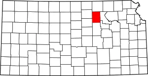 Map of Kansas highlighting Clay County | |
| Unincorporated communities | ||
| Ghost towns | ||
| Townships | ||
| Footnotes | ‡This populated place also has portions in an adjacent county or counties | |
| ||