Vining, Kansas
Vining is a city in Clay and Washington counties in Kansas, United States. As of the 2010 census, the city population was 45.[6]
Vining, Kansas | |
|---|---|
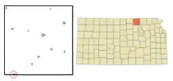 Location within Washington County and Kansas | |
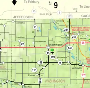 KDOT map of Washington County (legend) | |
| Coordinates: 39°34′3″N 97°17′35″W | |
| Country | United States |
| State | Kansas |
| Counties | Clay, Washington |
| Platted | 1877 (West Clifton) |
| Incorporated | 1885 |
| Area | |
| • Total | 0.21 sq mi (0.55 km2) |
| • Land | 0.21 sq mi (0.55 km2) |
| • Water | 0.00 sq mi (0.00 km2) |
| Elevation | 1,270 ft (390 m) |
| Population | |
| • Total | 45 |
| • Estimate (2019)[3] | 42 |
| • Density | 196.26/sq mi (75.82/km2) |
| Time zone | UTC-6 (CST) |
| • Summer (DST) | UTC-5 (CDT) |
| Area code | 785 |
| FIPS code | 20-73950 [4] |
| GNIS ID | 0473361 [5] |
History
Vining was originally called West Clifton, and under the latter name was laid out in 1877. It was renamed Vining in 1881, in honor of E. P. Vining, a railroad agent.[7]
Vining was once an important shipping point, being situated on the Republican River and at the junction of two railroads.[8]
The post office in Vining closed in 1955.[9]
Geography
Vining is located at 39°34′3″N 97°17′35″W (39.567460, -97.293109).[10] According to the United States Census Bureau, the city has a total area of 0.22 square miles (0.57 km2), all of it land.[11] The city is located next to Clifton.
Demographics
| Historical population | |||
|---|---|---|---|
| Census | Pop. | %± | |
| 1890 | 241 | — | |
| 1900 | 245 | 1.7% | |
| 1910 | 191 | −22.0% | |
| 1920 | 183 | −4.2% | |
| 1930 | 198 | 8.2% | |
| 1940 | 188 | −5.1% | |
| 1950 | 168 | −10.6% | |
| 1960 | 128 | −23.8% | |
| 1970 | 84 | −34.4% | |
| 1980 | 85 | 1.2% | |
| 1990 | 55 | −35.3% | |
| 2000 | 58 | 5.5% | |
| 2010 | 45 | −22.4% | |
| 2019 (est.) | 42 | [3] | −6.7% |
| U.S. Decennial Census | |||
2010 census
As of the census[2] of 2010, there were 45 people, 24 households, and 13 families living in the city. The population density was 204.5 inhabitants per square mile (79.0/km2). There were 27 housing units at an average density of 122.7 per square mile (47.4/km2). The racial makeup of the city was 100.0% White.
There were 24 households, of which 25.0% had children under the age of 18 living with them, 33.3% were married couples living together, 4.2% had a female householder with no husband present, 16.7% had a male householder with no wife present, and 45.8% were non-families. 41.7% of all households were made up of individuals, and 20.8% had someone living alone who was 65 years of age or older. The average household size was 1.88 and the average family size was 2.54.
The median age in the city was 41.5 years. 20% of residents were under the age of 18; 6.6% were between the ages of 18 and 24; 31% were from 25 to 44; 28.9% were from 45 to 64; and 13.3% were 65 years of age or older. The gender makeup of the city was 57.8% male and 42.2% female.
2000 census
As of the census[4] of 2000, there were 58 people, 26 households, and 15 families living in the city. The population density was 260.1 people per square mile (101.8/km2). There were 29 housing units at an average density of 130.0 per square mile (50.9/km2). The racial makeup of the city was 98.28% White and 1.72% Native American.
There were 26 households, out of which 23.1% had children under the age of 18 living with them, 50.0% were married couples living together, 3.8% had a female householder with no husband present, and 42.3% were non-families. 38.5% of all households were made up of individuals, and 11.5% had someone living alone who was 65 years of age or older. The average household size was 2.23 and the average family size was 3.07.
In the city, the population was spread out, with 25.9% under the age of 18, 6.9% from 18 to 24, 19.0% from 25 to 44, 36.2% from 45 to 64, and 12.1% who were 65 years of age or older. The median age was 40 years. For every 100 females, there were 100.0 males. For every 100 females age 18 and over, there were 126.3 males.
The median income for a household in the city was $27,500, and the median income for a family was $28,750. Males had a median income of $28,750 versus $8,750 for females. The per capita income for the city was $26,924. There were no families and 2.2% of the population living below the poverty line, including no under eighteens and none of those over 64.
Education
The community is served by Clifton-Clyde USD 224 public school district, which has three schools:
- Clifton-Clyde Senior High School, located in Clyde.
- Clifton-Clyde Middle School, located in Clifton.
- Clifton-Clyde Grade School, located in Clifton.
References
- "2019 U.S. Gazetteer Files". United States Census Bureau. Retrieved July 24, 2020.
- "U.S. Census website". United States Census Bureau. Retrieved 2012-07-06.
- "Population and Housing Unit Estimates". United States Census Bureau. May 24, 2020. Retrieved May 27, 2020.
- "U.S. Census website". United States Census Bureau. Retrieved 2008-01-31.
- "US Board on Geographic Names". United States Geological Survey. 2007-10-25. Retrieved 2008-01-31.
- "2010 City Population and Housing Occupancy Status". U.S. Census Bureau. Retrieved April 6, 2011.
- "Vining". Clay County, Kansas. Retrieved 15 May 2014.
- Blackmar, Frank Wilson (1912). Kansas: A Cyclopedia of State History, Volume 2. Standard Publishing Company. pp. 848.
- "Kansas Post Offices, 1828-1961, page 2 (archived)". Kansas Historical Society. Archived from the original on October 9, 2013. Retrieved 7 June 2014.
- "US Gazetteer files: 2010, 2000, and 1990". United States Census Bureau. 2011-02-12. Retrieved 2011-04-23.
- "US Gazetteer files 2010". United States Census Bureau. Archived from the original on 2012-01-25. Retrieved 2012-07-06.
Further reading
External links
Municipalities and communities of Clay County, Kansas, United States | ||
|---|---|---|
| Cities | 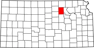 Map of Kansas highlighting Clay County | |
| Unincorporated communities | ||
| Ghost towns | ||
| Townships | ||
| Footnotes | ‡This populated place also has portions in an adjacent county or counties | |
| ||
Municipalities and communities of Washington County, Kansas, United States | ||
|---|---|---|
| Cities |  Map of Kansas highlighting Washington County | |
| Unincorporated communities | ||
| Footnotes | ‡This populated place also has portions in an adjacent county or counties | |
| ||