Clayton, New Mexico
Clayton is a town and county seat of Union County, New Mexico, United States.[4] As of the 2010 census, the city population was 2,980.[2]
Clayton, New Mexico | |
|---|---|
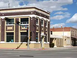 Main Street (2008) | |
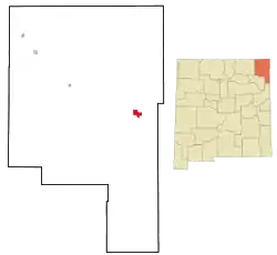 Location of Clayton within Union County and New Mexico | |
| Coordinates: 36°26′59″N 103°10′51″W | |
| Country | United States |
| State | New Mexico |
| County | Union |
| Area | |
| • Total | 7.79 sq mi (20.19 km2) |
| • Land | 7.78 sq mi (20.16 km2) |
| • Water | 0.01 sq mi (0.03 km2) |
| Elevation | 5,056 ft (1,541 m) |
| Population | |
| • Total | 2,980 |
| • Estimate (2019)[3] | 2,681 |
| • Density | 344.47/sq mi (133.00/km2) |
| Time zone | UTC−7 (Mountain (MST)) |
| • Summer (DST) | UTC−6 (MDT) |
| ZIP code | 88415 |
| Area code | 575 |
| FIPS code | 35-15720 |
| GNIS ID | 0905193 |
| Website | claytonnm.org |
History
.jpg.webp)
The Cimarron Cutoff of the Santa Fe Trail brought some of the first Americans through the Clayton region. The Santa Fe Trail was first established in 1821 after Spanish rule was evicted from Mexico which opened up trade between Santa Fe and the United States. William Becknell, also known as the Father of the Santa Fe Trail, became the first person to utilize the Santa Fe Trail as a trade route between the state of Missouri and Santa Fe. He established the Cimarron Cutoff, also known as the Cimarron Route, as a faster route between countries as the Cimarron Route shortened the Trail by more than 100 miles. The Cimarron Cutoff went straight through the Clayton region where travelers used the Rabbit Ear Mountain as a guiding landmark. Eventually travelers along the trail began to appreciate the rich soil around Clayton and the rolling green hills which were perfect for raising livestock. Cattle ranchers and sheepherders established ranches in the area, though they were large and far apart. That changed when the railroad came to the area and Stephen Dorsey, a nearby rancher, received the rights to the area where the railroad ran. He soon laid out a town site.[5]
Clayton is named for a son of U.S. Senator Stephen W. Dorsey, an Arkansas Republican, originally from Ohio, who served during Reconstruction. The town was established in 1887. The town was a livestock shipping center for herds from the Pecos River and the Texas Panhandle.[6]
Geography
According to the United States Census Bureau, the town has a total area of 4.7 square miles (12 km2), all land. Clayton has an elevation of approximately 5,050 feet (1,540 m) above sea level. It is located about 130 miles (210 km) northwest of Amarillo, Texas. Clayton is considered to be in the Plains region of New Mexico. This region stretches to the Sangre de Cristo Mountains down to the Guadalupe Mountains. Clayton is located in the northeast corner of New Mexico, 10 miles (16 km) from the border of Texas and 11 miles (18 km) from the border of the Oklahoma panhandle. Clayton is also located near two parks, Clayton Lake State Park, and Capulin Volcano National Monument. Not far away is Black Mesa State Park in Oklahoma. A carbon dioxide field called Bravo Dome can be found near Clayton and stretches nearly 1 million acres.[7]
Climate
Clayton has a typical New Mexico cool semi-arid climate (Köppen BSk) with hot summers and cool, dry winters. The normal monthly mean temperature ranges from 34.8 °F (1.6 °C) in December to 74.7 °F (23.7 °C) in July; on average, annually, there are 41 days with a maximum at or above 90 °F (32.2 °C), 13 days with a maximum that remains at or below freezing, and 2.2 days with a minimum at or below 0 °F (−17.8 °C).[8] Precipitation is low and usually confined to the monsoon season from June to September when thunderstorms are frequent; the annual mean precipitation is 15.8 in (400 mm).[8] Winter weather can vary greatly from warm and windy due to the influence of the chinook, to frigid and snowy when Arctic air moved southward from Canada. The seasonal (July through June of the following year) normal total snowfall accumulation is 28 in (71 cm), mostly occurring from November to March, occasionally in April, and very rarely does measurable snowfall occur in September, October or May.[8]
Record temperatures range from −21 °F (−29 °C) on January 4, 1959 to 105 °F (41 °C) on July 30, 1934 and June 27, 1924;[8] the record cold maximum is −1 °F (−18 °C) on January 11, 1963 and the day preceding the all-time record low, while, conversely, the record warm minimum is 74 °F (23 °C) on July 26, 1917.[8]
| Climate data for Clayton Municipal Airpark), 1981–2010 normals,[lower-alpha 1] extremes 1896–present | |||||||||||||
|---|---|---|---|---|---|---|---|---|---|---|---|---|---|
| Month | Jan | Feb | Mar | Apr | May | Jun | Jul | Aug | Sep | Oct | Nov | Dec | Year |
| Record high °F (°C) | 80 (27) |
83 (28) |
87 (31) |
92 (33) |
99 (37) |
105 (41) |
105 (41) |
102 (39) |
99 (37) |
93 (34) |
86 (30) |
83 (28) |
105 (41) |
| Mean maximum °F (°C) | 70.8 (21.6) |
71.4 (21.9) |
78.3 (25.7) |
83.4 (28.6) |
90.7 (32.6) |
96.5 (35.8) |
97.7 (36.5) |
95.1 (35.1) |
91.3 (32.9) |
84.9 (29.4) |
77.0 (25.0) |
70.4 (21.3) |
98.9 (37.2) |
| Average high °F (°C) | 48.9 (9.4) |
51.3 (10.7) |
58.5 (14.7) |
67.0 (19.4) |
75.6 (24.2) |
84.6 (29.2) |
88.6 (31.4) |
86.2 (30.1) |
79.3 (26.3) |
68.5 (20.3) |
57.2 (14.0) |
47.7 (8.7) |
67.9 (19.9) |
| Average low °F (°C) | 21.9 (−5.6) |
23.6 (−4.7) |
30.0 (−1.1) |
37.7 (3.2) |
47.3 (8.5) |
56.1 (13.4) |
60.8 (16.0) |
60.3 (15.7) |
52.3 (11.3) |
41.1 (5.1) |
30.0 (−1.1) |
21.9 (−5.6) |
40.3 (4.6) |
| Mean minimum °F (°C) | 5.8 (−14.6) |
6.2 (−14.3) |
14.8 (−9.6) |
24.2 (−4.3) |
33.8 (1.0) |
45.9 (7.7) |
54.1 (12.3) |
53.3 (11.8) |
39.1 (3.9) |
26.2 (−3.2) |
14.1 (−9.9) |
2.7 (−16.3) |
−3.1 (−19.5) |
| Record low °F (°C) | −21 (−29) |
−18 (−28) |
−11 (−24) |
7 (−14) |
20 (−7) |
31 (−1) |
40 (4) |
42 (6) |
26 (−3) |
6 (−14) |
−10 (−23) |
−14 (−26) |
−21 (−29) |
| Average precipitation inches (mm) | 0.28 (7.1) |
0.34 (8.6) |
0.95 (24) |
0.94 (24) |
1.96 (50) |
2.13 (54) |
2.66 (68) |
2.94 (75) |
1.67 (42) |
1.11 (28) |
0.45 (11) |
0.36 (9.1) |
15.79 (401) |
| Average snowfall inches (cm) | 5.1 (13) |
3.9 (9.9) |
6.3 (16) |
1.5 (3.8) |
0.7 (1.8) |
0 (0) |
0 (0) |
0 (0) |
0.3 (0.76) |
0.8 (2.0) |
3.0 (7.6) |
6.4 (16) |
28.0 (71) |
| Average precipitation days (≥ 0.01 in) | 3.0 | 3.3 | 5.2 | 4.7 | 7.0 | 7.7 | 8.9 | 9.5 | 6.7 | 4.7 | 3.3 | 4.0 | 68.0 |
| Average snowy days (≥ 0.1 in) | 3.6 | 3.0 | 3.1 | 1.1 | 0.3 | 0 | 0 | 0 | 0.1 | 0.4 | 1.8 | 3.9 | 17.3 |
| Source: NOAA[8][9] | |||||||||||||
- Notes
- Mean monthly maxima and minima (i.e. the expected highest and lowest temperature readings at any point during the year or given month) calculated based on data at said location from 1981 to 2010.
Demographics
| Historical population | |||
|---|---|---|---|
| Census | Pop. | %± | |
| 1910 | 970 | — | |
| 1920 | 2,157 | 122.4% | |
| 1930 | 2,518 | 16.7% | |
| 1940 | 3,188 | 26.6% | |
| 1950 | 3,515 | 10.3% | |
| 1960 | 3,314 | −5.7% | |
| 1970 | 2,931 | −11.6% | |
| 1980 | 2,968 | 1.3% | |
| 1990 | 2,484 | −16.3% | |
| 2000 | 2,524 | 1.6% | |
| 2010 | 2,980 | 18.1% | |
| 2019 (est.) | 2,681 | [3] | −10.0% |
| U.S. Decennial Census[10] | |||
As of the census[11] of 2010, there were 2,980 people, 1,025 households (only 77.8% of the population was living in households), and 623 family households residing in the town. The population density was 535.7 people per square mile (206.9/km2). There were 1,289 housing units at an average density of 273.6 per square mile (105.7/km2). The racial makeup of the town was 75.9% White (43.5% non-Hispanic white), 2.7% Native American, 2.6% black or African American, 0.5% Asian, 15.6% from some other races, and 2.6% from two or more races. Hispanic or Latino of any race were 51.1% of the population.
As of the 2000 census, there were 1,079 households, out of which 30.5% had children under the age of 18 living with them, 47.6% were married couples living together, 11.7% had a female householder with no husband present, and 35.9% were non-families. 33.7% of all households were made up of individuals, and 18.2% had someone living alone who was 65 years of age or older. The average household size was 2.32 and the average family size was 2.99.
In the town, the population was spread out, with 27.7% under the age of 18, 6.3% from 18 to 24, 23.8% from 25 to 44, 23.6% from 45 to 64, and 18.7% who were 65 years of age or older. The median age was 40 years. For every 100 females, there were 95.7 males. For every 100 females age 18 and over, there were 92.4 males.
The median income for a household in the town was $25,600, and the median income for a family was $30,109. Males had a median income of $26,554 versus $17,054 for females. The per capita income for the town was $13,967. About 14.2% of families and 17.9% of the population were below the poverty line, including 31.4% of those under age 18 and 9.1% of those age 65 or over.
Economy
Clayton has a rich history of commerce dating back to its founding in the 1800s. The railroad and nearby ranches caused Clayton to become a major livestock shipping center. A Dr. Pepper bottling plant was in town for a short time before moving back out. The town still thrives as a ranching and farming community, but has expanded its commerce to include multiple eating establishments, numerous shops, several dollar stores, two convenience stores, and multiple motels and campgrounds. The Ranch Market is the town's grocery store which has served the community faithfully for many years. Main Street and First Street are lined with shops including two flower stores and the town's western wear store: Ropes Western Wear and Casual. The town still maintains its small-town, country charm as the historic Hotel Eklund and the Luna Theater have been in operation for more than one hundred years, standing as a reminder to the town's earlier, simpler days.[12]
Community
Clayton holds a parade each Independence Day. The Herzstein Memorial Museum, run by the Union County Historical Society, is open without charge Tuesdays through Saturdays and by appointment. An official interpretative center of the Santa Fe Trail, the Herzstein focuses upon county and regional history.[13] Clayton Lake State Park, featuring a fishing lake and an extensive trackway of fossilized dinosaur footprints, is located 15 miles (24 km) north of town.
One of the oldest movie theaters in America stands in Clayton. Opened in 1916 as The Mission Theater, the Luna Theater is still in operation today, showing a different movie each weekend. “The Mission style exterior, and the interior, with its Art Deco style touches, has been painstakingly restored and refurbished over the years, including all new projection equipment.” [14] Although refurbished, much of the design is original, with original seating, light fixtures, and ticket booth. "Morris Herzstein built the theater and adjacent business block in 1916 after a disastrous fire wiped out his headquarters mercantile store... Before the Great Depression, the Mission Theater flourished and provided the magic of movies in Clayton, including memorable Christmas matinees offered free to children where Santa Claus would appear and give small presents to the crowd.” [15] In 1935, T.F. Murphy bought the Mission Theater, renamed it the Luna Theater, and added some renovations. The Luna Theater is one of the most historic theaters in the country, landing a special place on the National Register of Historic Places in 2007.[16]
Transportation
Highway connections include US Route 412 and US Route 64 concurrently through town running generally southwest to northeast, as well as US Route 87 running generally northwest to southeast.[17] Clayton is served by Clayton Municipal Airpark two miles east of town (KCAO, or FAA Identifier CAO), opened in December of 1946, and featuring two runways the longer of which is 6307 x 75 feet (1922 x 23 meters).[18]
Gallery
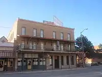 Eklund Hotel (established 1905), 2010.
 Luna Theater, 2010.
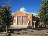 Union County Courthouse, 2010.
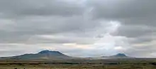
See also
References
- "2019 U.S. Gazetteer Files". United States Census Bureau. Retrieved July 27, 2020.
- "2010 City Population and Housing Occupancy Status". U.S. Census Bureau. Retrieved December 1, 2011.
- "Population and Housing Unit Estimates". United States Census Bureau. May 24, 2020. Retrieved May 27, 2020.
- "Find a County". National Association of Counties. Archived from the original on 2011-05-31. Retrieved 2011-06-07.
- "New Mexico Office of the State Historian | places". newmexicohistory.org. Retrieved 2017-02-23.
- Historical marker in Clayton, New Mexico
- "Bravo Dome Holds Largest Carbon Dioxide Deposits". American Profile. 2004-08-08. Retrieved 2017-02-24.
- "NowData – NOAA Online Weather Data". National Oceanic and Atmospheric Administration. Retrieved 2020-08-29.
- "Station Name: NM CLAYTON MUNICIPAL AIR PARK". National Oceanic and Atmospheric Administration. Retrieved 2020-08-29.
- "Census of Population and Housing". Census.gov. Retrieved June 4, 2015.
- "U.S. Census website". United States Census Bureau. Retrieved 2008-01-31.
- "Clayton, New Mexico Chamber of Commerce - Union County". claytonnm.org. Retrieved 2017-02-23.
- Herzstein Memorial Museum
- "Luna Theater".
- "How New Mexico Is Saving Its Historic Movie Theaters".
- Essay by ALLison Mize. 2017.
- "Clayton, NM". Google Maps. Retrieved December 2, 2020.
- "Clayton Municipal Airpark". AirNav.com. Retrieved December 2, 2020.
External links
| Wikimedia Commons has media related to Clayton, New Mexico. |
Municipalities and communities of Union County, New Mexico, United States | ||
|---|---|---|
| Town | 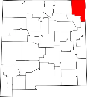 Map of New Mexico highlighting Union County | |
| Villages | ||
| CDP | ||
| Other unincorporated communities | ||
| ||